
Mapping the seafloor has been a longterm goal among oceanographers. The invention of the sonar, initially created to help defend against submarine attacks, greatly aided this effort in the early 20th century. However, early sonar was very coarse and many deep regions of the oceans could not be easily mapped.
Now, scientists have new techniques that can provide high resolution images of the seafloor, even at great depths, that may allow us to better map at least some of Earth’s last great frontiers, the ocean floor. The Seabed 2030 project will also enable a full map of the seafloor to be produced by 2030.
Challenges to mapping changes in the ocean floor
One complication of mapping the seabed is that, in places at least, it is changing constantly and highly detailed maps would need updating if they are to be represent what is there. Now, researchers can produce centimeter-scale resolution of the seabed using combined techniques that also enable changes to be monitored.
The Monterey Bay’s Aquarium Research Institute (MBARI), a non-profit oceanographic research center, has been studying Sur Ridge off Monterey Bay in California now for over a decade. To produce a high level of detail in this area, traditional sonar and even modern multibeam sonar would not be sufficient as it is far too coarse.

Geospatial technologies used to map changes to small regions of the seafloor
The highly detailed method requires two main data points. First, a Low-Altitude Survey System (LASS), which is a modified remote underwater vehicle equipped with a scanner system that hovers above the seafloor, is used. In addition, the Seafloor Instrument Node (SIN), which is a type of recording device that records movement of currents, is placed at key points.

These instruments work together to then create not only highly detailed images of the seabed but they also enable the mapping to be dynamic and changing seabed structure and currents can be observed.
In highly turbid areas, such as the massive deep-sea ravines that form Sur Ridge in the Pacific, the seafloor is constantly evolving. Turbidity currents shape the seabed here, where essentially underwater mudflows are formed by 2-7.4 mile-per-hour moving currents that constantly shape the seafloor. These currents effectively reform, remove sediment, and cover areas of the seabed that constantly reform any given area.
Mapping the dynamic ocean floor
This level of detail enables such dynamic places to be mapped for the first time. The equipment may not be suitable in mapping very large segments of the oceans currently, but it does enable areas of high interest to be mapped in detail. Potential application, in addition to mapping certain dynamic seafloor areas, include better understanding deep-sea ecosystems that could be mapped in high resolution maps so that individual animals on the seafloor could be studied.[1]
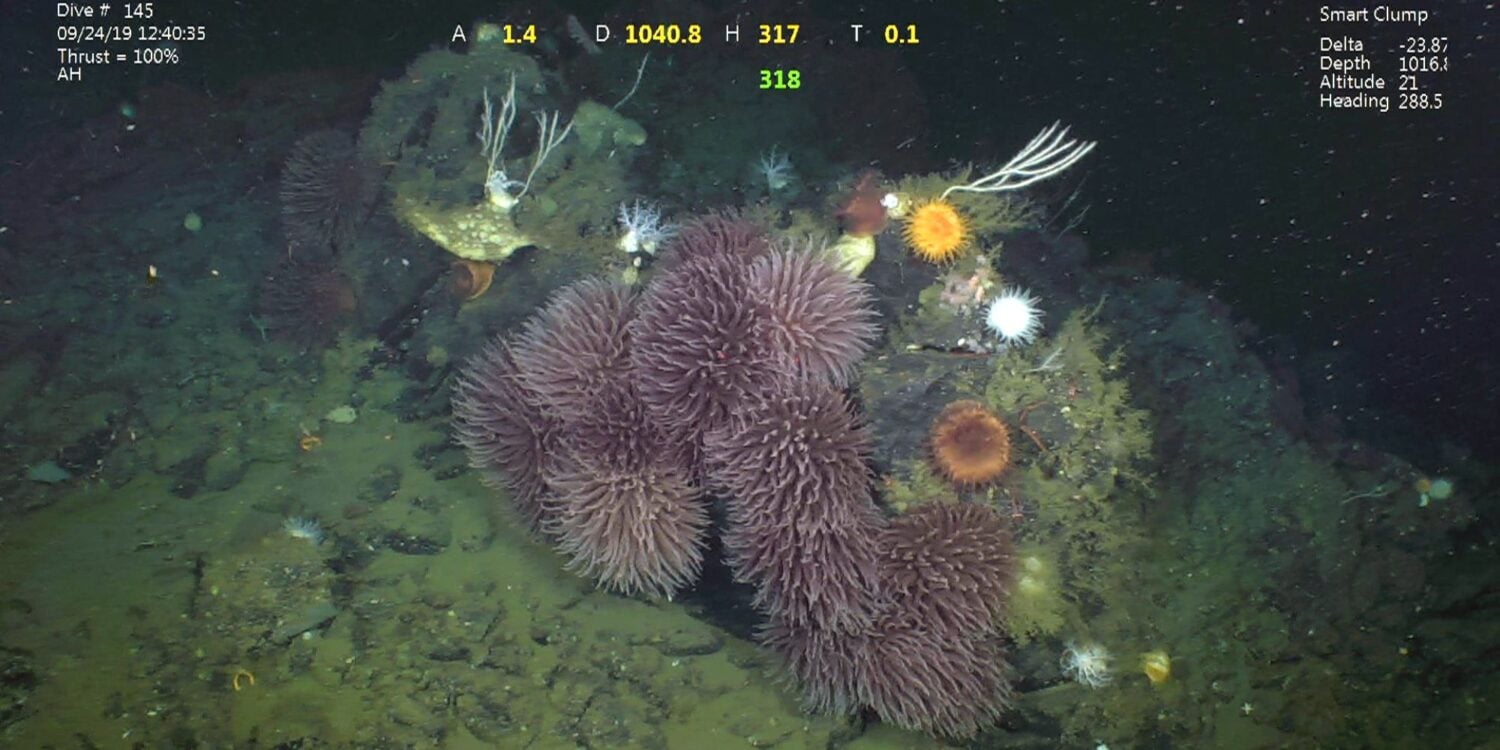
Seafloor mapping is helping scientists discover new ecosystems
The same MBARI team, in fact, has discovered new ecosystems never known before by producing higher detailed seafloor maps. Ecosystems of bubblegum corals, swathes of yellow coral, white sponges and a vampire squid are among their discoveries.
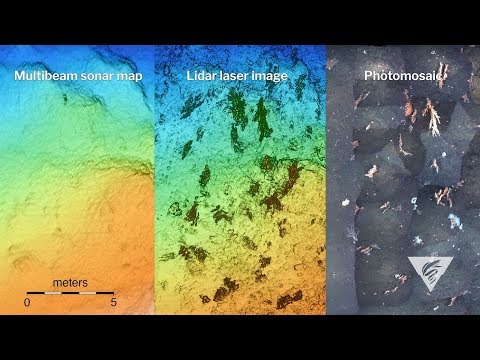
Not only have they created highly detailed maps, but their approach is to produce different levels of detail. First, a multibeam sonar is used to survey a wide area at 25-meter resolution. Then, an autonomous under water vehicle scans the topography at one-meter resolution. Finally, a remotely operated vehicle moves close to within three meters from the surface and uses lasers, sonar, strobe lights, and stereo cameras to develop a five-centimeter and centimeter-scale resolution maps. In fact, photographs could be used to create millimeter-scale resolution if desired. All of these methods are very intensive and require a lot of time, similar to the data point system described earlier.[2]
Contributing to the wider goal of mapping the world’s entire ocean floor by 2030
The wider goal for mapping the seafloor is to contribute to the produce the first complete map of the ocean floors by 2030. The Nippon Foundation-GEBCO Seabed 2030 Project developed in 2018 to map the seafloor by 2030. In 2017, only 6 percent of the world’s ocean floor was known. Now, the initiative will attempt to map every corner of the planet’s seafloor and provide the data for free for scientists and others to use. This initiative brings many different teams, including university-based, private companies, and public institutions together to create the data.[3]
Mapping the seafloor is perhaps the largest frontier left to explore on Earth. The new techniques developed by MBARI are not likely to be used to map the entire seafloor but specific regions of greater interest can now be mapped at centimeter-level resolution for the first time. The worry for some is that while the data would be useful to have, the seafloor could become an area of intense commercial exploitation, causing ecosystem harm.
Protecting the ocean floor
Laws protecting the seafloor are recognized and the International Seabed Authority, a UN-supported initiative that has 167 member states, has been entrusted with creating international laws that should prevent harm to the ocean floor.[4] Nevertheless, as our technology to map improves and we learn more about the ocean floor, the temptation to explore how the ocean floor can be used will be there.

Balancing protection of our seabed and exploration will need to be achieved so that data from any initiative that produces useful ocean floor maps are used for efforts that do not lead to new sources of pollution or environmental destruction. It remains to be seen how we will use the new data that maps the seafloor.
References
[1] The new method for mapping the seafloor is described here in this article:
Nava, R. (2023, July 12). Innovative MBARI technology reveals processes that sculpt submarine canyons. MBARI. https://www.mbari.org/news/innovative-mbari-technology-reveals-processes-that-sculpt-submarine-canyons/
and
Wolfson-Schwehr, M., C.K. Paull, D.W. Caress, R. Gwiazda, N.M. Nieminski, P.J. Talling, C. Carvajal, S. Simmons, and G. Troni (2023). Time-lapse seafloor surveys reveal how turbidity currents and internal tides in Monterey Canyon interact with the seabed at centimeter-scale. Journal of Geophysical Research: Earth Surface. doi.org/10.1029/2022JF006705
[2] An earlier description of the work by the MBARI can be found here: https://www.smithsonianmag.com/science-nature/can-scientists-map-entire-seafloor-2030-180978004/.
[3] For more on the 2030 initiative in mapping the seafloor, see: https://seabed2030.org/.
[4] For more about regulation affecting the seafloor, see: https://www.un.org/en/chronicle/article/international-seabed-authority-and-deep-seabed-mining.