
Freshwater is so vital for societies yet we actually know little about the quality of those resources, including basic information such as the volume of water in a given freshwater source. Some of the larger bodies of freshwater are well known to us, but medium to smaller systems are rarely measured and what may be changing or affecting them is mostly unknown.
Now, work led by NASA and Centre National d’Études Spatial (CNES) are seeking to change this by creating a new satellite platform, using a new radar system, that will allow us to measure global freshwater bodies.
Using Satellites to Measure 90% of the World’s Lakes, Rivers, and Reservoirs
A new satellite mission, called the Surface Water and Ocean Topography (SWOT), will measure over 95% of the planet’s lakes, rivers, and freshwater reservoirs. This will be an unprecedented attempt to get a better understanding of as many freshwater bodies as possible.

SWOT will involve a satellite making measurements that can be used to assess how freshwater and the Earth’s water cycle are affected by human activity, climate change, and wider natural change. While the satellite is being developed, it is scheduled to be launched in November 2022 from the Vandenberg Space Force Base in California.
From what we know, SWOT will measure the height of water bodies as well as area, which will allow us to understand how much water volume is moving during the hydrologic cycle. Lakes larger than 15 acres or 6 ha will be measured.
Overall, the satellite might be able to measure somewhere between 2-6 million lakes around the world. It will also be able to measure rivers more than 100 m across.
By better understanding water budget, scientists hope to better understand and predict the effects of floods or drought on freshwater bodies. While the focus will be on freshwater areas, the satellite should be able to measure eddies in oceans. This will include eddies that are less than 60 miles/100 km across. Scientists hope that SWOT will also better enable us to predict and understand ocean flow.[1]
Using Radar to Measure Water
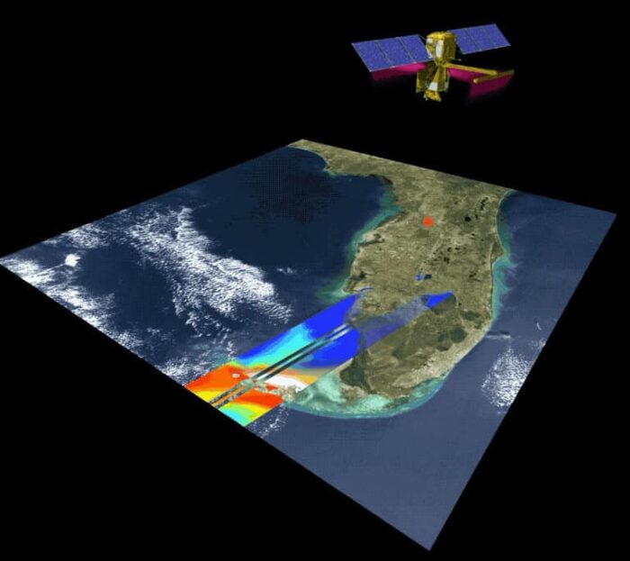
The Jet Propulsion Laboratory has taken a key lead in designing the new satellite. The main instrument used is a radar tool called Ka-band Radar Interferometer. The radar signals will bounce pulses from water’s surface; two antennas will receive the signal at the same time. The radar system will measure a 75-mile wide area (120 km) across the Earth’s surface at a given time.

The goal will be to measure freshwater bodies every 21 days. By surveying the Earth’s lakes, rivers, reservoirs, and seas at least twice every 21 days, the satellite will cover at least 90% of the planet, enhancing ocean circulation models, weather forecasts, and freshwater management efforts worldwide.
Improvements in Water Measurement Tools
Overall, water managers around the world will be greatly aided by this new tool as they can now better predict water volume and water budget. Furthermore, the satellite will address a key goal outlined in the 2007 National Research Council Decadal Survey, which was to create a satellite system better capable in measuring freshwater resources and the water cycle.[2]
While existing instruments can measure height, the new tools will enable volume to be measured over time. Researchers will be able to compare height and area measurements over time and days, allowing a better understanding of how volume and water budget is changing.
Last year, there was a research paper that used the ICESat-2 satellite to conduct a global freshwater survey. However, the results from the new SWOT tool should make measurements more accurate and illuminating.[3]
SWOT has an official site created by NASA. This will provide updated information about the satellite as well as provide ways in which data could be accessed once the new platform is spaceborne.
While SWOT has not launched, many scientists are already busy working to create methods to better apply data. For instance, recent research has been developed to better measure discharge data from river systems as the satellite will be able to capture variation in given rivers over a 21-day period.[4]
Basic data on water volume for freshwater systems is largely missing for many key resources around the world. Many major cities and countries are in a precarious state when it comes to depending on potentially vulnerable freshwater sources.
The new SWOT tool will enable water managers to better balance adaptation and freshwater resource needs for populations that might be vulnerable to climate change.
References
[1] For more on SWOT, see: https://www.nasa.gov/feature/jpl/us-european-satellite-will-make-world-s-first-global-freshwater-survey
[2] More information on SWOT’s capabilities can be seen here: https://www.jpl.nasa.gov/missions/surface-water-and-ocean-topography-swot.
[3] An earlier study looking at freshwater and lakes around the world using the ICESat-2 was published in 2021 and more details can be found here: Cooley, Sarah W., Jonathan C. Ryan, and Laurence C. Smith. 2021. ‘Human Alteration of Global Surface Water Storage Variability’. Nature 591 (7848): 78–81. https://doi.org/10.1038/s41586-021-03262-3.
[4] For more on calculating river discharge using SWOT, see: Gejadze, I., P.-O. Malaterre, H. Oubanas, and V. Shutyaev. 2022. ‘A New Robust Discharge Estimation Method Applied in the Context of SWOT Satellite Data Processing’. Journal of Hydrology 610 (July): 127909. https://doi.org/10.1016/j.jhydrol.2022.127909.