
Researchers used 1,756 Landsat images to develop a GIS database of river widths for the entire North American continent. Previously, river widths were estimated based on topographic maps and calculating the river discharge measured at certain points along the watershed. Using software developed in Exelis VIS IDL, hydrologists from the University of North Carolina were able to extract river width calculations using remote sensed data.
Called North American River Width Data Set (NARWidth), the GIS data is available for downloading in shapefile format with by tile or as a bulk download. In order to avoid seasonal variations in river widths, images for each river were selected during a time of that river’s average flow.
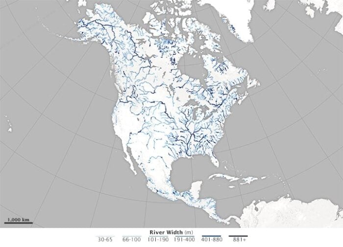
The resulting dataset contains attribute data about the river’s width, the number of channels/braids, whether the segment is a river or a reservoir as well as lat/long coordinates. The resulting map of the river width data shows that the widest rivers are found along the Yukon in Alaska, the Mackenzie in Canada’s Northwest Territories, the Hudson in New York, the St. Lawrence along the border of New England and Quebec, and the Mississippi.
The availability of a more accurate river width database will allow for the analyses of flood hazards, studies of ecological diversity, and estimates of the volume of greenhouse gases released by rivers and reservoirs due to bacterial activity.
More: A Satellite View of River Width

References
Allen, G. H., Pavelsky T.M., (2015), Patterns of river width and surface area newly revealed by the satellite-derived North American River Width data set. Geophysical Research Letters. doi: 10.1002/2014GL062764
Pavelsky, T.M. and L. C. Smith , RivWidth: A Software Tool for the Calculation of River Widths from Remotely Sensed Imagery, IEEE Geoscience and Remote Sensing Letters, v. 5 no. 1, January 2008.