
Earlier this spring, Laurence Smith, professor of Earth, Environmental and Planetary Sciences at Brown University, released his latest work, “Rivers of Power: How a Natural Force Raised Kingdoms, Destroyed Civilizations, and Shapes Our World.” The book is a scientific dive into how rivers shape the surface of our planet and of their roles in human history.
Hydrology has long been a focal point of Smith’s research. His previous book (published in 2010), “The World in 2050” looked, in part, at how the climate change in the Arctic would open up shipping lanes previously impassable due to ice.
Mapping the Location of River Borders
A recently published article by Smith is a co-authored study with primary author Sarah Popelka that discusses the development of a geospatial dataset of global subnational river borders featured in Smith’s Rivers of Power book. Rivers have long played a role in delineating political borders, both international and subnational.
Popelka and Smith explain, the natural barriers creating by the presence of these waterways is “due to their inherent linearity, perceived impassibility, and the fact that they physically incise and divide the landscape.” Despite the prevalence of using rivers to delineate borders, the authors noted that “no global study has quantified the importance of rivers on territorial delimitation at subnational scales.
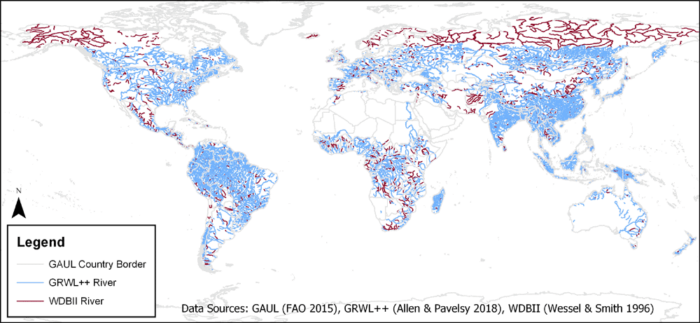
To create the Global Subnational River Borders dataset, two hydrologic and one political dataset were used. The Global River Widths from Landsat Plus Plus (GRWL + +) provided river planforms between 60° N and S latitudes.
To supplement data outside of those bounding latitudes and to infill missing gaps in that GIS dataset, the CIA World Databank II (WDBII) dataset was also used.
For political borders, the Global Administrative Unit Layers (GAUL) dataset was used.

An open access article, Rivers as political borders: a new subnational geospatial dataset, goes into detail about the pre-processing and quality assurance methodologies used throughout the project to reconcile the different spatial resolutions and inherent errors of each GIS dataset.
The article also provides a detailed analysis breaking down the use of rivers as borders at a national, state, and local level both globally and categorized by continent.
The Global Subnational River Borders GIS data is freely available as three datasets in shapefile format at local (Level 2), state (Level 1), and national (Level 0) scales.
The Study and Dataset
Popelka, S. J., & Smith, L. C. (2020). Rivers as political borders: a new subnational geospatial dataset. Water Policy. https://doi.org/10.2166/wp.2020.041
Global Subnational River Borders GIS dataset: https://zenodo.org/record/3906567#.XvN-GGhKjIU.