
arcgis
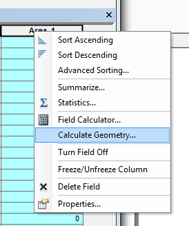
Calculating Polygon Area in ArcMap
Here are the steps for calculating the area of a polygon using ArcGIS.

How To Make Area Cartogram Maps in ArcGIS
If you have data with disparate values between areas, making an area cartogram is an effective way to map out those values. This article provides a tutorial on how to make area cartogram maps using ArcGIS.

Using GIS to Showcase College Acceptance
Every June, my local paper is filled with the local private school announcements containing lists and lists and lists of ...
Sample Esri Technical Exam Questions
Esri is now offering sample questions for Esri’s ArcGIS Desktop Exams. The sample questions are accessible from Esri’s Training page. ...
ArcGIS on the Cheap
If you’ve been wanting to get into using ArcGIS but can’t afford the commercial price tag, Esri is offering a ...
Geocoding Shortcut: Google Maps to ArcMap
Geocoding a dataset to produce a georeferenced layer requires access to a basemap to which the location data is tied. ...

BantamGIS
Michael Chamberlain discusses the motivation and process behind the creation of his website, BantamGIS.com.
Digitizing Using ArcGIS
This tutorial reviews basic digitizing using the editor toolbar in ArcGIS desktop.

The Geography Network
Esri launched the Geography Network as a collaborative system for sharing digital geographic information on the internet.

Introducing the ArcGIS Platform: One Look, Many Applications
Perhaps the most immediate impact for users leaving the 2000 ESRI User Conference is the announcement of the unification of the ESRI product line, called ArcGIS.
Realizing the Benefits of an N-Tiered Enterprise GIS
This year's conference is an especially significant event in the history of the GIS industry because of several concurrent developments in technology.