
Agricultural landscapes, when viewed from space, reveal distinct patterns shaped by historical practices, local geography, and technological influences. These visible patterns range from precise geometric designs to complex mosaics.
Agricultural field patterns often reflect centuries of land ownership, surveying systems, irrigation methods, and local geography. From medieval strip farming to modern center-pivot irrigation, satellite imagery reveals how people have shaped landscapes for food production.
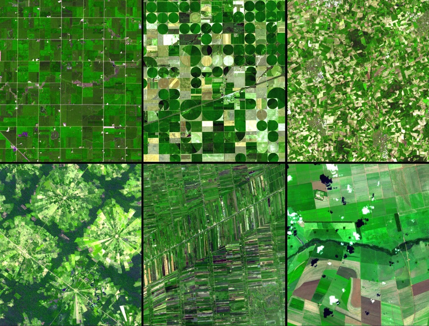
Germany’s Random Agricultural Field Pattern
Germany’s irregular agricultural pattern is a legacy from the Middle Ages. Fields of varying sizes can be seen with villages and towns interspersed. The landscape of Germany inspired geographer Johann Heinrich von Thünen to create the first geographical models related to agricultural land use.

Minnesota’s Grid Agricultural Pattern
These agricultural fields in Minnesota are shaped in regular rectangular grids. The very regular grid layout in Minnesota follows early nineteenth-century surveying where the size of the fields was based on the requirement to be large enough for efficient mechanized farming. Dirt roads separate each field.

Narrow-strip farming in Poland
Satellite imagery taken over Sułoszowa, near Kraków, Poland, shows distinctive narrow-strip farming patterns. Known as strip farming or “long-lot agriculture,” this method originated in medieval Europe to ensure each farmer had equitable access to essential resources like roads or waterways. These elongated, thin strips create a recognizable visual pattern of parallel agricultural plots that persist today.
These historical land divisions remain a prominent feature of the rural landscape as these plots have been passed down from generation to generation.

Crop Circles in Egypt
This view of circular farming patterns in Sharq El Owainat, southwest Egypt, was taken by an astronaut onboard the International Space Station.
The crop circles are the result of center-pivot irrigation. With center-pivot irrigation, water is extracted from a well and fed into the system via a tube coupled to metal frames. The metal frames are mounted on wheels, and electric motors propel them in a circle while spraying water as they go.
The Sahara Desert’s distant agricultural outpost is around 290 kilometers (180 miles) from the nearest city and 210 kilometers (130 miles) from the Toshka lakes.

These crop circles exist because of the Nubian Sandstone Aquifer System found buried beneath the sand. For Egyptians who live outside of the reaches of the Nile River, the aquifer is their only supply of water.
Land in parts of Egypt outside the region of the Nile Delta are considered “hyper-arid” – with an average yearly precipitation of 0 millimeters, more than 95% of Egypt is inhospitable desert.
Center Pivot Farming in Kansas
The practice of center pivot agriculture can also be seen in this satellite image of Kansas. Like the circular fields in Egypt, these fields are created by irrigation equipment that rotates around a central pivot, although in Kansas the water source and climate are very different.

Radiating Agricultural Fields
In this planned community near Santa Cruz in Bolivia, agricultural fields radiate out from small communities among the rainforest. The radiating layout reflects planned agricultural settlements, with homes clustered near the center and farmland extending outward into the surrounding rainforest.

Taking Pictures of Agricultural Patterns from the International Space Station
Astronauts living in the International Space Station are part of an important effort to document irrigation methods around the world and find out how effective they are.
Astronauts provided high definition photographs of a region of Libya near to a town called Al Jawf. The region is highly isolated; you would have to go more than 560 miles to get to the nearest major city. Agriculture is essential to the people and animals living in Al Jawf.

The photo captures different agricultural patterns in the desert, each of which represents a unique irrigation method.
The honeycombed center is the remnants of the first planned agricultural efforts in the 1970s, while the larger circles were later dug as a pivot irrigation system designed to conserve as much water as possible. Another smaller grid irrigation system is also visible as an older but still viable method of irrigating crops. (Related: What are Qanats?)
A nearby oasis gives the residents of Al Jawf a break from the desert, all thanks to the largest known fossil water aquifer in the world. This aquifer is known as the Nubian Sandstone Aquifer. This underground water source is one of the last remnants of a time when the Sahara was much wetter and supported a more densely vegetated landscape.
Unfortunately, the aquifer is a non-renewable resource, as the region around Al Jawf only gets a tenth of an inch of rain every year. Despite the water shortage, the residents of Al Jawf are doing all they can to conserve as much water as possible.
What shapes agricultural landscapes
Agricultural landscapes are shaped by geography, history, technology, and climate. Viewed from space, these patterns reveal not only how crops are grown but also how societies have adapted farming to different environments around the world.
Frequently asked questions
Why are some farm fields circular?
Circular fields are created by center-pivot irrigation systems, where irrigation equipment rotates around a central well to water crops evenly.
Why are farm fields rectangular?
Rectangular fields are often the result of land surveying systems that divided land into regular parcels. In countries such as the United States and Canada, many agricultural grids reflect historical township and range surveys.
Why do some farms have long, narrow fields?
Long-strip fields developed to give individual landowners equal access to roads, rivers, or fertile land. This pattern originated in medieval Europe and can still be seen in places such as Poland.
Why can agricultural patterns be seen from space?
Agricultural fields often cover large areas with distinct shapes, colors, and textures. Satellite imagery makes these patterns easy to identify because they contrast with surrounding forests, grasslands, or deserts. Differences in crops, irrigation methods, field boundaries, and soil moisture make agricultural landscapes stand out in satellite imagery.
What can satellite images reveal about agriculture?
Satellite imagery can reveal irrigation methods, field boundaries, crop patterns, land ownership history, and how farmers have adapted agriculture to local geography and climate.
References
Hansen, K. (2017, March 11). Cultivating Egypt’s desert. NASA Earth Observatory. https://earthobservatory.nasa.gov/images/89820/cultivating-egypts-desert
Hollier, A., & Wilkinson, J. (2017, January 2). Al Jawf, eastern Libya. NASA Earth Observatory. https://earthobservatory.nasa.gov/images/89341/al-jawf-eastern-libya
Hollier, A. (2017, September 18). Crop circles in Sharq el Owainat. NASA Earth Observatory. https://earthobservatory.nasa.gov/images/90937/crop-circles-in-sharq-el-owainat
This article was originally written on November 2, 2017 and has since been updated.
