
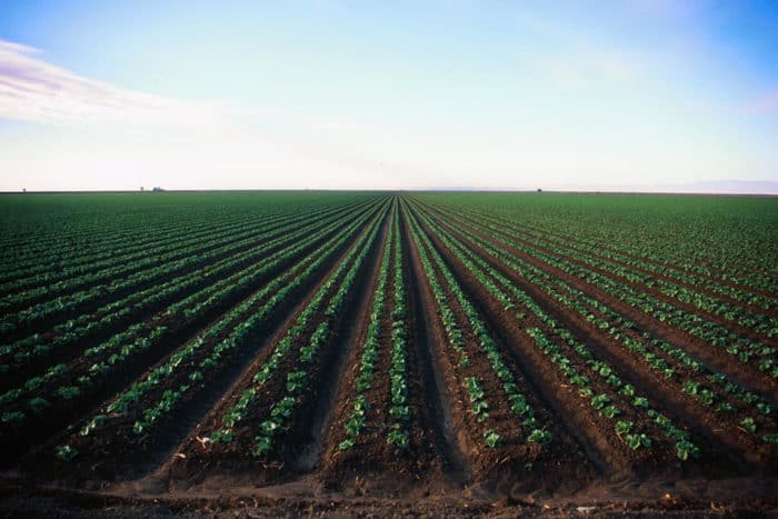
Agriculture faces many challenges today, including climate change, depleted land quality, water shortages, poor water quality, and economic pressures. Farmers, however, do now have greater access to computational and geospatial tools that can also at least help mitigate some of these challenges.
Using GPS to Monitor Crop Health
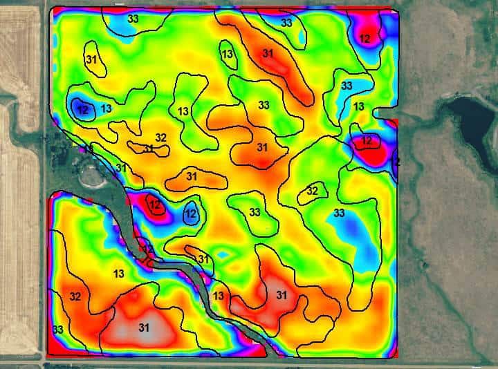
Technologies used today include GPS tracked monitors that help record information including weather, soil quality, crop progress, or even livestock-related data. In particular, Internet of Things (IoT) devices provide not only real-time data but GPS tracking enables geospatial approaches to assess information, such as volumetric measurements or creating heat maps to measure spatial intensity.
By monitoring closely crops using small devices placed by plants or soils, then farmers are better able to forecast crop health and output prior to harvest. This enables farmers to also better plan in advance.

Furthermore, such devices help save costs because farmers can plan more exactly how much fertilizer, water, and other measures are needed based on real-time conditions and forecasting. This can help limit waste, particularly from fertilizers, which can have negative consequences for water quality as runoff from farms can greatly increase nitrate and phosphate levels in water.
Using Geospatial Technology to Time When to Plant Crops
Increasingly, farming is seen as a major contributor to climate change, in particular carbon released from soils and emissions from livestock has been seen as having negative consequences for our climate. By creating more efficient decisions on when to crop, minimizing the number of livestock and resources needed for agriculture, farmers can at least help to mitigate their impact on climate change emissions.[1]
Drones and Agriculture
Aerial technologies are also helping farmers make better choices by using unmanned aerial vehicles (UAVs) as well as satellite technologies. For instance, the Soil Moisture Ocean Salinity (SMOS) satellite, launched in 2009, is able to collect microwave data from the Earth’s surface, which can allow planners and farmers to forecast crop production and assess the likelihood of drought or even flooding prior to events occurring. This enables decisions to be made well in advance, helping to mitigate stresses for crops.
For decades, Landsat and other more recently developed multi-spectral satellites, such as Advanced Spaceborne Thermal Emission and Reflection Radiometer (ASTER), have been used to provide Normalized Difference Vegetation Index (NDVI) data. This allows farmers to monitor the health of their crops and estimate harvest for wide areas.
On the other hand, small, cheap drones are often used to provide more fine-scale assessment, including data on plant height, count and biomass estimates, indication of disease, presence of weeds, plant health, field nutrients, and volumetric data using simple cameras that can create photogrammetric data.[2]
GIS and Agriculture
Powerful modeling tools, such as Decision Support System for Agrotechnology Transfer (DSSAT) and Soil-Water-Air-Plant (SWAP), have also become incorporated with common and open source GIS tools such as GRASS, enabling farmers and analysts to forecast water availability and crop health without great expense.
These tools are increasingly incorporated with high performance computing (HPC) or cloud-based computing, enabling large-scale analyses for large areas in the tens of thousands of hectares to be estimated.[3]

Many of the key advancements powering the utility of IoT, remote sensing, and simulation applications have to do with improved capabilities in machine learning, in particular deep learning techniques.
Deep learning using convolution neural networks (CNNs) has enabled farmers to make better decisions from collected data. For instance, using drone data, CNNs can be used to count the number of livestock or make measurements on crops using visual data.
Data from IoT devices can also be assessed, helping to find emerging patterns of crop stress before it becomes too serious. These advancements have helped to make machine and deep learning techniques become increasingly critical for decisions that help save resources while responding to threats.[4]
We have seen many transformations to technologies and techniques used that can benefit agricultural decisions. Farmers have a greater variety of data to choose from to help with decisions needed that not only benefit them but also can have a positive impact on the environment.
Costs and technology access may limit some farmers from benefiting changes occurring for modern agriculture; however, many of these technologies are declining in cost and, in fact, many of the tools, such as GIS and some of the satellite data, are free to use. Improving how agriculture is done will increasingly be more critical as we try to be more effective in how we use landscape resources to mitigate negative impacts on the economy and climate.
References
[1] For more on IoT and agriculture, see: Jaiganesh, S., Gunaseelan, K., Ellappan, V., 2017. IOT agriculture to improve food and farming technology, in: 2017 Conference on Emerging Devices and Smart Systems (ICEDSS). Presented at the 2017 Conference on Emerging Devices and Smart Systems (ICEDSS), IEEE, Mallasamudram, Tiruchengode, India, pp. 260–266. https://doi.org/10.1109/ICEDSS.2017.8073690.
[2] For more on a recent article discussing using satellite sensors and UAV data for agriculture, see: Mazzia, V., Comba, L., Khaliq, A., Chiaberge, M., Gay, P., 2020. UAV and Machine Learning Based Refinement of a Satellite-Driven Vegetation Index for Precision Agriculture. Sensors 20, 2530. https://doi.org/10.3390/s20092530.
[3] For more on some models used for agriculture, see: Wang, Xiaowen, Cai, H., Li, L., Wang, Xiaoyun, 2020. Estimating Soil Water Content and Evapotranspiration of Winter Wheat under Deficit Irrigation Based on SWAP Model. Sustainability 12, 9451. https://doi.org/10.3390/su12229451
[4] For more on a recent deep learning tool in agriculture, see: Zheng, Y.-Y.; Kong, J.-L.; Jin, X.-B.; Wang, X.-Y.; Su, T.-L.; Zuo, M. CropDeep: The Crop Vision Dataset for Deep-Learning-Based Classification and Detection in Precision Agriculture. Sensors 2019, 19, 1058.