Burial of deceased is a sensitive topic in most countries. All the more, this makes understanding the spatial and social properties of cemeteries important for for planning purposes and for understanding past events.
Studying Historical Burial Sites With GIS
In World War I, war cemeteries were often hastily created after battles.
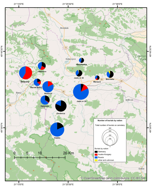
This was the case in modern day Poland, where Austro-Hungarian and Russian cemeteries from battles were recently excavated and GIS was used to study them. These cemeteries displayed multi-national and multiethnic identities of soldiers fighting together, such as Austro-Hungary, where shortly after World War I these social groups would not have fought together since by that time new countries had been forged.
Different units that suffered casualties, and their burial in specific areas, were mapped along with the relationship of the dead with each other.[1]
This helps to show how historical patterns and events have shaped cemeteries, as these cemeteries were products of practices that disappeared or changed after the war.
GIS and Mass Burial Sites
For more modern conflict regions, cemeteries have often been hastily made for mass casualty events. Typical burial customs are often not utilized.
In studying the conflict in the former Yugoslavia in the 1990s, it was shown that burials coincide with where a violent event occurred, sometimes existing cemeteries would be used, and, at times, houses or gardens near houses were also used as burial sites. These patterns of behavior can be used to model predictive regions of where war burials and cemeteries may exist.
Optimal forging theory concepts, where people maximizing on areas that make it easier for burial of war dead during conflict, avoiding detection and time spent having to bury the body are aspects that could be modeled to predict likely areas for burials.
Cost-distance surfaces could be created to determine the cost of burying someone in times of conflict, revealing like areas of cemeteries.[2]

Using GIS to Manage Cemeteries
In modern cemeteries and cities, rapidly growing cities and populations have created the challenge of forecasting how much cemetery space is needed in areas to be built. This is particularly the case in societies that often require full burial rather than cremation.
In Malaysia, GIS has shown the potential as a tool for cemetery management to determine efficient use of space and act as a spatial database of people buried. This helps to then keep track of individuals in a cemetery and also forecast future needs of that cemetery based on population growth, while data tracked could be used to estimate when the cemetery might run out of space based on population estimates.[3]
In the United States, forecasting space needs in cemeteries for veterans based on their population in an area has been one application that GIS can be used to combine demographic and spatial data from cemeteries to determine the adequacy of sites for veterans.
This was done in Virginia, where it was shown that veterans might be living too far from cemeteries to adequately serve the aging veteran population in that state.
More cemeteries in the near future might be needed in cases where veteran populations might be relatively high in given counties.[4]

Natural Planning Burials and GIS
Another area where GIS has utility for cemeteries is planning natural burials, where planting of trees or plants rather than headstones has developed into a popular concept in some areas of the UK.
In this case, using the parameters required for natural burials to be possible, data in a GIS was used to demonstrate that natural burials help to increase cemetery space in places where there are relatively greater pressures for having adequate burial space.
Natural burials have been shown to have enhanced space in cemeteries as space that would have not normally been considered as part of cemetery grounds have been utilized.[5]
Using GIS to Assess Patterns of Burials
GIS has been used to reassess older burials, particularly in conflict, when burials are often rapid and patterns of burials might now be forgotten to us.
GIS can also be used to predict where unknown mass graves or cemeteries could be found based on known patterns of choices in armed conflicts.
GIS has also been shown to be effective in managing modern cemeteries, particularly as space becomes an increasing problem in highly urban or high population regions.
References
[1] For more on World War I cemeteries in Poland and the use of GIS, see: Lisek, K., & Nieścioruk, K. (2015). The cartographic methods of presentation and GIS tool in analysis of historical data on the example of Great War cemeteries in southern Poland. Polish Cartographical Review, 47(4). https://doi.org/10.1515/pcr-2015-0015
[2] For more on optimal forging theory and its use in predicting locations of likely cemeteries during conflict, see: Congram, D., Kenyhercz, M., & Green, A. G. (2017). Grave mapping in support of the search for missing persons in conflict contexts. Forensic Science International, 278, 260–268.
[3] For more on the management of cemeteries using GIS, see: Mohamad Daud, Noor Shafiqah and Sulaiman, Noralfishah and Anjang Ahmad, Mustaffa (2013) Issues and challenges in Muslim Cemetery Management (MCM) in Malaysia. In: 1st FPTP Postgraduate Seminar 2013, 23 December 2013, Fakulti Pengurusan Teknologi dan Perniagaan, UTHM .
[4] For more on using GIS for finding adequate space and locations for veteran cemeteries, see: Rephann, T. J. 2008. Spatial analysis in veterans’ cemetery location. http://econ.ccps.virginia.edu/RePEc_docs/ceps_docs/cem_pap.pdf.
[5] For more on natural burials and GIS in the UK, see: Clayden, A., Green, T., Hockey, J., & Powell, M. (2017). Cutting the lawn − Natural burial and its contribution to the delivery of ecosystem services in urban cemeteries. Urban Forestry & Urban Greening. https://doi.org/10.1016/j.ufug.2017.08.012
