
Typically where there is a need for satellite imagery, geospatial scientists would either go to a government-supported website that has free data or data for purchase or purchase imagery from a private satellite company. The greater the resolution of the image the more expensive imagery has been, with sub-meter imagery usually being the most expensive at hundreds of dollars for small scenes. For both private and government support satellites, data have traditionally come from fairly large, often more than 1000 kg, expensive systems that orbit the Earth for a few years or more. However, the marketplace for satellite data as well as the quality of data is now changing.
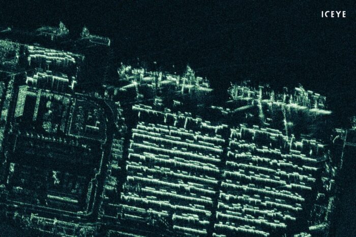
More companies are now entering the marketplace for satellite systems and the reason why they can do this is because satellites have become small, often less than 100 kg, sometimes the size of suitcases with even smaller devices proposed or created for lower orbits that weigh less than 10 kg. What has limited most small satellites is the quality of data. While these satellites are often relatively cheap their instrumentation and small size limits resolution and quality. Some companies have started to change this. One company is ICEYE, a Finish-based firm, which has recently released a radar-based satellite system that can provide imagery to less than 1 meter resolution. In fact, after processing, image resolution for the synthetic-aperture radar (SAR) image is about 0.5 meters, which can be taken in nighttime, cloudy, or other conditions. Compared to Sentinel-2, an EU satellite sponsored system which typically provides about 10-meter resolution for radar images, this is remarkable. The satellite is under 100 kg, making it the smallest satellite to have ever achieved sub-meter resolution for SAR imagery.[1]What is also remarkable is how quickly ICEYE has been able to achieve this low resolution. Only recently it was able to produce 3-meter resolution SAR satellites; now that sub-meter barrier, something thought to be very difficult for small satellites, has been broken. By the end of 2019, ICEY will have five SAR satellites, which will likely make them among the global leaders in this type of imagery for private satellite companies.[2]

It is not just ICEYE but other companies are getting into the act of creating small or even micro- and nanosatellites. A recent study has shown that the small satellite industry has since 2012 become a rapidly growing industry. Companies such as Terran Orbital are not only developing tens of satellites that can provide geospatial and imagery data, but a growing market is Internet of Things (IoT) satellites. Another recent company is Hiber, also focusing on IoT satellites. Many of these smaller companies are backed by much larger defense or investment firms such as Boeing and Goldman Sachs. While larger companies had traditionally ruled the market, smaller companies are now being invested in by the larger markets to develop new, innovative satellites that can be easily launched and sent into different levels of orbit. Another area of growth is firms purchasing small satellites so they can be used for geospatial consulting that increasingly uses artificial intelligence and machine learning. For instance, companies that monitoring the number of cars in parking lots, mining companies interested in forecasting metal resources, or real estate investors and realty firms evaluating the quality of properties are some of the purchasers of these small satellite systems.[3]

There has been criticism that small satellite companies are creating more space junk, including through the use of non-reusable rockets, leaving a large carbon footprint, and leaving satellites and debris in space that can harm other satellites or create a situation where it might be difficult to fly into space without hitting flying objects. One firm, Orbex based in London, is tackling this by creating an energy efficient rocket, using bio-propane fuel, that is not only reusable, but has a zero-shock system that leaves zero space debris as the rocket enters orbit and releases its satellites. The company plans to launch its first satellite sometime by 2021 with the launch of nanosatellites used for IoT infrastructure.[4]
Small scale satellites are changing how we can acquire our data as geospatial analysts. In many cases, satellite data quality are not only improving but costs are likely to drop as it becomes easier to create high quality imagery at a more affordable price. Outside of only imagery, small satellites are transforming IoT by enabling us to better connect with systems around the world that allows easier monitoring and more data capture and transfer of information globally, facilitating geospatial research and even investments for firms.
References
[1] For more on the press release about ICEYE’s latest satellite, see: https://www.iceye.com/press/press-releases/iceye-releases-first-under-1-meter-resolution-spotlight-radar-imagery-from-small-sar.
[2] For further press information on the satellite releases, see: https://www.iceye.com/press/press-releases/iceye-reports-successful-july-2019-launch-of-two-sar-satellites.
[3] For more on new companies that have begun to use small satellites for a variety of areas such as IoT or geospatial monitoring and analysis, see: https://www.nanalyze.com/2019/03/smallsat-companies-building-launching-satellites/
[4] For more on Orbex, see: https://ukdefencejournal.org.uk/orbex-to-launch-swiss-astrocast-sa-nanosatellites-from-uk-spaceport/