Looking for global GIS data? Listed here are free sources for finding GIS data in both vector and raster formats including satellite imagery.
Natural Earth World GIS Data
This is probably one of the best sources for free global GIS data. The site was initiated in 2008 by Nathaniel Vaughn Kelso and Tom Patterson and data from the site is coordinated by a group of volunteers.
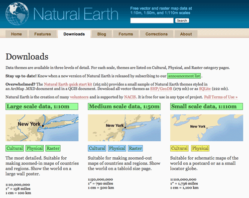
Users looking for a global collection of free GIS data should explore Natural Earth’s GIS data selection. For a starter sample of world GIS data, Natural Earth offers a Natural Earth quick start kit download with a sample set of world GIS layers. The zip file includes administrative layers such as populated places, hydrology layers including coastlines and rivers and lakes, and a hill shade layer for the world. The vector layers in the quick start kit are at a scale of 1:10m and the raster layer is at a scale of 1:50m. Included in the quick start kit to get you a jump start are an ArcMap file (.mxd) and QGIS file (.qgis) that loads the sample data into the respective map files already stylized.
Individual layers can be downloaded from Natural Earth for cultural, physical, and raster data at three scales of resolution: 1:10m, 1:50m, and 1:110m. All of the GIS data offered at Natural Earth is public domain and free to use.

OpenStreetMap Data
OpenStreetMap (OSM), the crowdsourced worldwide geographic database, allows users the ability to download its data. The downloading data page has instructions about how to access OpenStreetMaps’s data. Planet.osm provides for the extraction of the entire worldwide data or you can extract smaller geographic areas using OSM’s export tab.

Global Elevation Map
The U.S. Geological Survey (USGS) and the National Geospatial-Intelligence Agency (NGA) have an aggregated world digital elevation model that was released in November of 2011 called the Global Multi-resolution Terrain Elevation Data 2010 (GMTED2010). The world DEM aggregates the highest resolution data from a variety of sources. More information: GMTED2010.

GeoNames
GeoNames is a database of 8 million geographical names with longitude and latitude coordinates, available under a creative commons attribution license which means the GIS data can be downloaded for free. The geographic data from GeoNames is accessible through a number of web services, GeoNames offers a good solution for integrating geographical names into interactive mapping websites. The BBC, Nike, Greenpeace and LinkedIn already use GeoNames in this way.
Vector Map (VMap)
Vector Map (VMAP), is a vector-based collection of GIS data covering the world at various detail levels. Level 0 (VMap0) has global coverage, and is entirely in the public domain. VMap0 is at a scale of 1:1 million. It is a slightly more detailed reiteration of the Digital Chart of the World (DCW) which was developed in the 80’s and early 90’s, and is therefore dated. However depending on your purposes, VMap0 may still offer valid geometry for features that do not change significantly (such as coastline and drainage) and offers a good starting point for areas of the World where vector data is hard to come by. Level 1(VMap1) is at a scale of 1:250k, and about a quarter of the World’s coverage is in the public domain.
World Database of Large Urban Areas
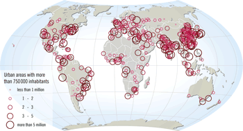
Nordpil has made available their layer of Large Urban Areas for downloading. Tabular data from the United Nation’s World Urbanization Prospects: The 2007 Revision Population Database was joined to the 2008 cities dataset that comes with Esri’s Data & Maps sample data and other sources of data.
The database is available for unrestricted download, under the Creative Commons 2.5 attribution license. This gives you the right to reuse and modify the data, as long as Nordpil and the UN Population Division are properly credited.
The data is available in Shapefile and KMZ formats as well as in tabular format. Presentations of the data are also available including an animation of maps spanning the years 1950 to 2050 and a map of large urban areas in 2005.

General Bathymetric Chart of the Oceans (GEBCO)
The Common Bathymetric Graph of the Sea (GEBCO) is designed to provide the most trustworthy, publicly-available bathymetry GIS data for the world’s oceans. The Common Bathymetric Graph of the Sea (GEBCO) work on the growth of a variety of bathymetric information places and information products. The GEBCO is a group of worldwide professionals, and provide gridded bathymetric information places, the GEBCO Electronic Atlas, the GEBCO world map and the GEBCO Gazetteer of Underwater Function Titles.
The GEBCO One Minute Grid offers a global, one-arc minute bathymentry dataset. and a global 30 arc-second grid. Both grids are freely available and downloadable along with the custom software required to extract the grids to a useable format.
More World GIS Data Resources
Digital Chart of the World Server
This web site will allow you to download the boundaries and layers of different countries, in Arc/INFO export format.
USGS EarthExplorer
Find digital datasets of both imagery and GIS databases from this site. Select data by coordinates, place name or interactively through the map.
Mapping the World at Night
A look at nighttime global mapping.

Nice resource for professional land surveyors…thanks for sharing!