
Human Geography
Human geography is a branch of geography that focuses on the study of the human population and their cultural, economic, and social interactions with the environment. It examines the distribution of human populations across the globe, the impact of human activity on the natural environment, and the ways in which people use and manage natural resources.
Learn about the different areas of human geography including economic geography, population geography, cultural geography, and more.

Most Tourists Don’t Stray Far From the Road When Taking Photos in National Parks
Cartography students mapped out 800,000 geotagged photos posted to Flickr to analyze how far those pictures were taken from a road.

Mumbai Police Fighting Noise Pollution With Enforced Patience
In an effort to lower noise levels, the Mumbai Police have set up noise meters at select traffic signals around the city called "Punishing Signals".

Mapping the Transportation Network of the Roman World
ORBIS is a mapping project developed by researchers at Stanford that reconstructs the financial and spatial challenges of transporting goods and people during Roman times about 200 CE.

How Many Countries Are There?
The answer to the question of how many countries there are in the world remains a question with many different possible answers.

Monitoring Crop Production Via Satellite
To cope with ever-changing agricultural needs and conditions, the USDA’s National Agricultural Statistics Service (or NASS) uses data from Landsat to monitor crops in the contiguous United States.

Biodiversity and Climate Change Adaptation
Many cities globally are forging ahead with climate change adaptation.

Satellite Data Shows That Tilling Less Leads to Healthier Soils
Researchers applied machine learning to satellite-derived datasets to to analyze tillage practices and crop yields in the US Corn Belt between 2005 and 2017.
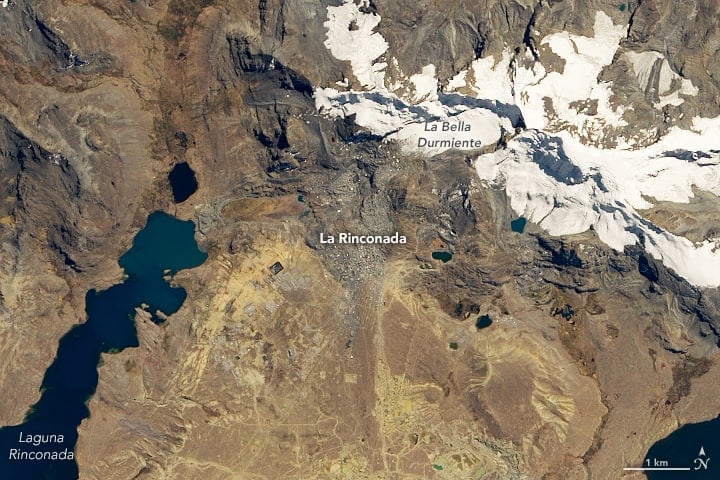
Highest Permanent Settlement in the World
Located at 5,000 meters (3 miles) above sea level, La Rinconada in southeastern Peru is the highest permanent settlement in the world.
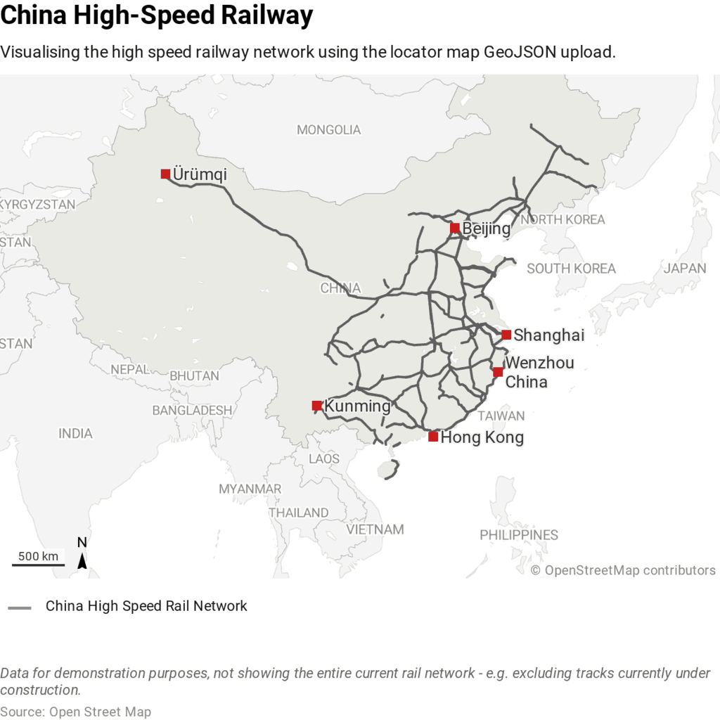
Which Country Has the Most High Speed Rail Lines?
While China only started developed its HSR network in 2003, it has quickly become the country with the most high speed rail lines.

Artificial Intelligence Was Used to Discover a New Nasca Line
Researchers tested out the use of artificial intelligence to assist with finding new Nasca lines.

Review | The Best American Travel Writing 2019
The 'Best American Travel Writing 2019' features pieces on either dangerous places or the pursuit of the exotic as well-informed as they are well-written.

Satellite Imagery Shows How Much of South Dakota’s Flooded Fields Were Unable to be Farmed
In August of 2019, the U.S. Department of Agriculture reported that South Dakota had 3.9 million “prevented planting” acres.
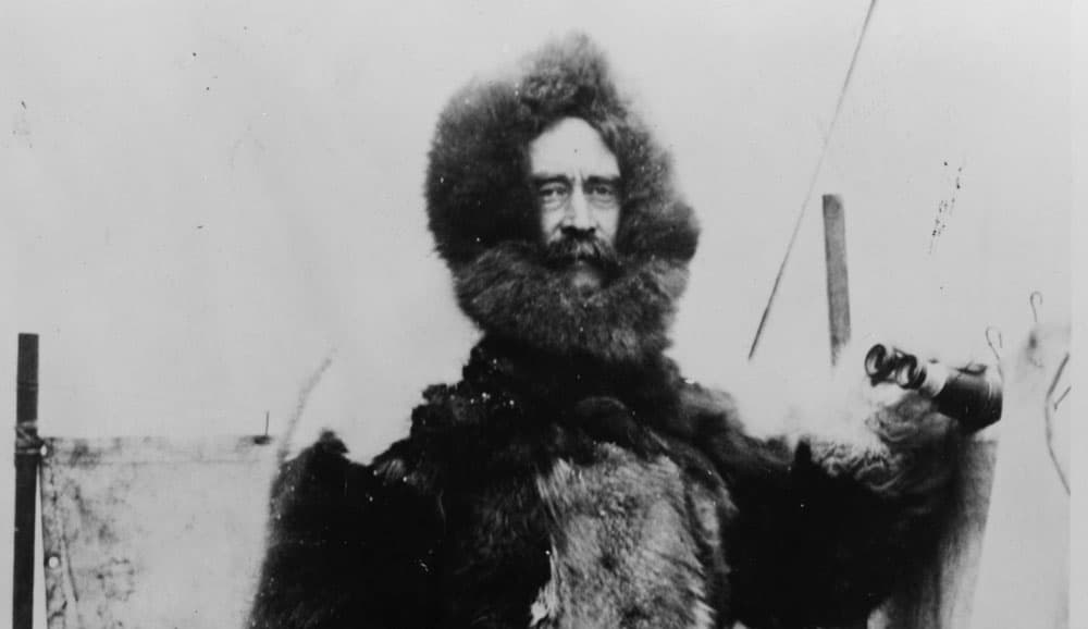
Review | Peary’s Arctic Quest
Peary’s Arctic Quest: Untold Stories from Robert E. Peary’s North Pole Expeditions is both a rigorous scholarly work and a popular exposition of Robert Peary’s Arctic achievements and his legacy.

Himalayan Glacier Melt Mapped By Analyzing Old Spy Photographs
Declassified Cold War-era spy satellite photographs have shown how much the melting of hundreds of Himalayan glaciers has accelerated in recent decades.

Indonesia Will be Moving Its Capital
Driven by congestion and the gradual sinking of Jakarta, Indonesia announced that it will be moving its capital to a location on the island of Borneo.

Review | On the Plain of Snakes: A Mexican Journey
In On the Plain of Snakes: A Mexican Journey, Theroux is determined to experience the real Mexico, as a traveler, not a tourist.

How Hydropower is Changing the Balkan Landscape
How is the proliferation of hydro power plants (HPPs) changing Balkan peninsula's landscapes?

Increasing Tree Cover Linked to Improved Community Mental Health
Studies show that adults who live in a neighborhood that has 30% or more tree coverage have lower odds of experiencing psychological distress in their lifetime.

The U.S. is Losing 36 Million Trees Per Year
A study from the US Forest Service has found that, nationally, tree cover is declining at a rate of 175,000 acres per year which is the equivalent of about 36 million trees lost each year.

Urban Beehives Help Reveal Sources Of Pollution In Cities
Researchers have tested honey from six Vancouver neighborhoods from varying districts (urban, industrial, residential and agricultural) for levels of lead, copper, zinc, and other pollutants.

How Redlining Communities Affects Health
New methods have also been created to measure inequality to housing and health so that they can be empirically demonstrated

Review | Horizon
Horizon by Barry Lopez can, perhaps, be best described as an intellectual autobiography by means of geography and the abiding truths of the natural world.

Geography of International Travel by U.S. Presidents
So where have U.S. presidents traveled? This article explores the geography of international travel by sitting U.S. presidents.

The Oldest Continuously Occupied Human Settlement
Erbil Citadel, located in the center of Erbil, Iraq, is the oldest continuously occupied human settlement.

Review | Who Owns England?
The concentration of wealth – in England, particularly landed wealth – is a most serious issue.

Are Safaris the Best Answer for Elephant Conservation?
Tourism can be a great conservation tool as long as it is monitored closely.