
Cancer screening is important to the medical profession, not to mention human health, as it helps to minimize costs and helps to provide medical services in a timely manner. GIS has the potential to play an important role, particular in cancers where environmental, socio-economic and resource access links could be found.
Using GIS to map cancer clusters
One way spatial analysis could be used is to determine if there are clusters where certain cancers concentrate.
For example, in the case of cervical cancer, it was found that ethnic and socio-economic indicators (mainly poverty and lack of insurance) often cluster in some regions, such as in areas of Newark, Trenton or Camden in New Jersey, where there are also strong incidences of cervical cancer.
What the analysis shows is that areas that might be more distant to clinics that can conduct screening might have higher rates of cervical cancer, due to a lack of screening access. Policies may need to reorient how screening access is provided particularly where larger trends of spatial clustering of cervical cancer are evident, such as the towns mentioned for New Jersey.[1]
In another study on breast cancer, it was found that rural areas in Nebraska had higher incidents rates, particularly areas that were more distant from screening centres. Using hot spot analysis on access to mammography facilities, based on distance, and using data on mammography facilities showed that rural populations distant from centres had more late-stage diagnoses of breast cancer.

The implications are that using spatial analysis could allow medical providers to adapt to where needs are greatest rather than building facilities concentrated solely in urban areas. It is likely that many other states show a similar pattern.[2]
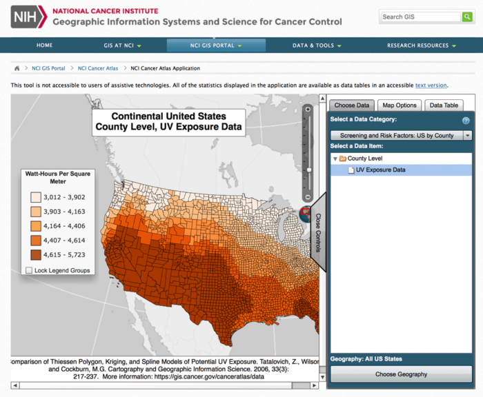
Other cancers could be triggered by poor environment, such as pollution from exhaust including ultrafine particles (UFPs). Using a land use regression model from where UFPs concentrated showed that distance to concentrations did have an effect on prostate cancer.
Those who were closer to UFPs tended to have a greater likelihood of developing prostate cancer with other factors, such as age, are controlled. Such analysis could improve as well be demonstrating what time of day exposure may correlate to cancer incidents.[3]
Spatial correlation of cancer incidence
Some researchers are calling for more proactive approaches that attempt to anticipate where rates of cancers may become higher due to underlying factors that have spatial correlates.
For instance, the use of Bayesian modeling could help estimate which regions are likely to have not only increased cancer rates but scenarios could be adjusted to distance to clinics and treatment centres. This would then be used to estimate the best location for clinics to maximize coverage such as in epidemiology-related cases.[4]
Benefits of spatial analysis in cancer screening
Overall, the medical community has become increasingly aware of the benefits of spatial analysis in cancer screening, resulting for increased calls for better data collection. More medical researchers are understanding that GIS can play an important role in research and policy, but the lack of good, high resolution spatial data could limit efforts.
Patient data may now need to incorporate more specific location information, such as not only where people live but also where they may travel to during the day.[5]
There is evident need for collecting more and specific spatial data, as analyses and research has shown that many common cancers, including breast cancer and prostate cancer, have clear spatial properties.
Commonly, data are only available at the zip code level. While this might be adequate for some types of cancer, it may not be suitable for all. What this indicates is that the medical community is now beginning to increasingly realise that the collection of spatial information should become a priority area in order to develop more effective screen procedures that identify areas of need and factors that could affect incidences of cancer, such as environmental causes or socio-economic influences.
References
[1] For more on the relationship between cervical cancer and spatial clustering, see: Roche, L. M., Niu, X., & Henry, K. A. (2015). Invasive Cervical Cancer Incidence Disparities in New Jersey—a Spatial Analysis in a High Incidence State. Journal of Health Care for the Poor and Underserved, 26(4), 1173–1185. https://doi.org/10.1353/hpu.2015.0127.
[2] For more on breast cancer screening and spatial patterns in Nebraska, see: Chandak, A., Nayar, P., & Lin, G. (2018). Rural-Urban Disparities in Access to Breast Cancer Screening: A Spatial Clustering Analysis: Disparities in Breast Cancer Screening. The Journal of Rural Health. https://doi.org/10.1111/jrh.12308.
[3] For more on the relationship of UFPs and prostate cancer, see: Weichenthal, S., Lavigne, E., Valois, M.-F., Hatzopoulou, M., Van Ryswyk, K., Shekarrizfard, M., … Parent, M.-E. (2017). Spatial variations in ambient ultrafine particle concentrations and the risk of incident prostate cancer: A case-control study. Environmental Research, 156, 374–380. https://doi.org/10.1016/j.envres.2017.03.035.
[4] For more on how Bayesian modeling could be used in cancer research and policy, see: Kirby, R. S., Delmelle, E., & Eberth, J. M. (2017). Advances in spatial epidemiology and geographic information systems. Annals of Epidemiology, 27(1), 1–9. https://doi.org/10.1016/j.annepidem.2016.12.001.
[5] For more on the need for better data collection and database access for research and policy, see: Schootman, M., Gomez, S. L., Henry, K. A., Paskett, E. D., Ellison, G. L., Oh, A., … Berrigan, D. A. (2017). Geospatial Approaches to Cancer Control and Population Sciences. Cancer Epidemiology Biomarkers & Prevention, 26(4), 472–475. https://doi.org/10.1158/1055-9965.EPI-17-0104.