
By: Dr. Alexander Zipf
Recently a first version of the interactive 3D city information system Heidelberg-3D.de was made available online. It can be used freely by anybody.
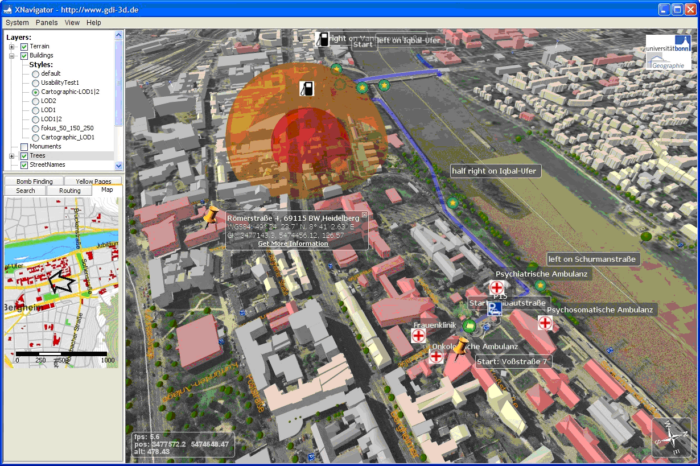
The core of the system is one of the first implementations of the OpenGIS Web 3D Service (OGC W3DS) discussion paper. The system comes with a free 3D-Client called <XNavigator>. This client is a Java WebStart-Application and will be installed automatically if you follow the respective URL and if Java 6 is already installed on the computer.
XNavigator allows the user to explore and analyse the 3D city and landscape models which are streamed by the W3DS server.
A range of applications have been integrated in order to let the user work with the 3D model. In contrast to conventional proprietary 3D GIS, the whole system is totally based on standards of the Open Geospatial Consortium (OGC) .
The main goal of the project is to build and evaluate a whole 3D spatial data infrastructure (3D-SDI) based on OGC services, not only to develop a further visualization component.
Such service oriented architectures (SOA) gain importance also for GI applications. Heidelberg-3D implements for the first time a whole set of relevant OpenGIS services and integrates those into a comprehensive web-based 3D application in the integrated client XNavigator. The system consists of the following OGC services:

- The W3DS (Web 3D Service) itself as 3D portrayal service. It has its own 3D database and tools for generating optimized 3D models from raw data, including CityGML as import.
- OpenLS Route Service (3D-Routing with height profile & animation – routes also over bridges)
- Geocoder of the OGC OpenLS Utility Service (adress search and vice versa).
- OpenGIS Web Processing Service (WPS) . There are several WPS processes involved: for preprocessing of the geodata, as well as special analysis functions. Among others one WPS process also uses the
- OpenGIS Sensor Observation Service (SOS) for real time weather data within the air pollution scenario.
- OpenLS Directory Service, performs spatial queries for Points of Interest (POIs) and display them in 3D within our W3DS-Client XNavigator. The POIs have been imported from the OpenStreetMap data. They contain a variety of important and interesting locations like shops, ATMs, cafes, pharmacies, bus stops, hotels, night clubs, and many more. The possible categories are unlimited and the data is being extended rapidly. The user can click on the 3D scene and search for specific types of locations within a selected radius. The result is shown as 3D labels.

– Of course the system also includes the well known base components for SDIs, such as the
- Web Map Service (WMS), (overview map)
- Web Feature Service (WFS) (e.g. CityGML)
- Catalogue Service (CS-W).
Further components will be added as the project proceeds (e.g. specialized WPS processes and other Sensor Web services).
When someone wanted to publish 3D-city models on the internet, there were only some proprietary digital globes or special solutions of a few companies available until recently. But as the success of the OGC’s WMS demonstrates, distributed solutions based on standardized web services provide an attractive alternative.
The system described here tries to achieve this.
The benefit of transmitting real 3D scenes is evident (also known from typical virtual globes), as the 3D city models can be experienced interactively and also enriched with further information and applications. For example with this solution data providers can integrate their own highly detailed digital elevation models – so that the buildings actually fit to the ground.
A special feature of the system is, that the appearance of the 3D visualization can be controlled from the client through the OGC Symbology Encoding Specification. Similar to the well known WMS Styled Layer Descriptor (SLD) this approach allows realizing thematic cartography in 3D.
One usage is to harmonize the look of data that comes from different server in one scene. An integrated SLD-editor allows doing this by the user on the fly. A range of visualization styles are already offered by the server.

The 3D model has been generated in very close cooperation with the surveying office of the city of Heidelberg. Further content stems from other partners or has been digitized within the project itself. Most of the data has been generated from 2D data automatically. The system includes the complete set of buildings of the city of Heidelberg (~40.000) that can be accessed from the web. Further it features a 5 meter-DEM, landuse, airborne photographs, street names and a range of other data such as historic flood areas, parking lots, laterns, street and traffic signs, trees and even a detailed model of the Virgin Mary that has been generated from terrestrial laser scan. A increasing set of important buildings and bridges have been modeled in higher detail and have textures. All data is preprocessed for efficient streaming and managed within a geodatabase.
The goal of the project, that is funded by the Klaus-Tschira-Foundation in Heidelberg, is to develop new technologies and standards for the interoperable processing, visualization and analysis of 3D city and landscape models. The first version of the system will be developed further and has also already been tested successfully with 3D models of other cities.

About the author:
Prof. Dr. Alexander Zipf
Chair of Cartography, Department of Geography, University of Bonn
zipf@geographie.uni-bonn.deFurther information, videos, screenshots and the link for starting the actual online system can be found at: www.gdi-3d.de / www.heidelberg-3d.de
www.geographie.uni-bonn.de/karto
“laterns”? I wonder if they’re displayed in enough detail to see what they are.
Have a look at http://www.k2vi.com
We have a fully interactive in realtime 3d GIS and CAD based software product. The software doesnt compromise with database size. Ceck ou t the website for the Pictometry work we have been doing.