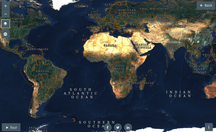
Scientists often require cloud free views of the world when utilizing satellite imagery. However, this is nearly impossible when taking a single image, as nearly 70% of the globe is covered by clouds in any one instant.
Sentinel-2 is an earth observation satellite program consisting of two satellites (Sentinel-2A and 2B; launched in 2015 and 2017 respectively) developed by the European Space Agency. The data provided are utilized for understanding land cover, agriculture, forestry and environmental data.
The best spatial resolution in the Sentinel-2 program is 10 m, where the satellite provides multispectral bands covering near infrared and shortwave infrared. The Sentinel-2 program is intended to complement the previous SPOT missions and provide a next generation capability for land use and land cover observations.[1]
Methods of Removing Cloud Cover from Satellite Imagery
Several methods have been developed to remove cloud cover.
Merging cloud-free imagery with cloud cover satellite imagery
One approach has been to take a cloud free image of a place and simply merge it with a place where a cloud exists. The problem with this approach is that often the same areas look different (e.g., seasonal changes) over time, resulting in an image that is seen as manipulated.[2]
Pixel sorting to create cloud-free satellite imagery
A more common approach today is using pixel sorting, where multiple images are utilized and images are selected that are not too dark (e.g., shadowing) or bright (i.e., cloud cover). With more rapid computation, and improvement in machine learning methods such as random forest techniques, it has become far easier for many images to be seamlessly merged rather than one image at a time.
This has the advantage of smoothing edges, where the edges seem seamless through data combination of multiple images rather than obviously merged when only one image is used. By combining the data, even from different seasons, the imagery begins to look similar across time, giving an appearance of one image snap that has no cloud cover.
Furthermore, data from other satellite systems, including Landsat, could be utilized along with newer systems in the data merger methods.
Such approaches are forms of automated, machine learning classification, where it simply takes many images and merges the scenery together based on pattern observation of pixels in the same scene over time that compares similarities of pixels.[3]
This is very similar to how popular earth viewers such as Google Earth are used today.

Automated Cloud Detection
Related methods that have been integrated in automated approaches is cloud detection, where images that have clouds need to be detected where clouds can then be masked or removed from a given dataset.
Cloud screening
The general type of method where cloud detection is utilized is sometimes called cloud screening.[4] In effect, it uses time series data in a classification approach that looks for large variance in reflectance across time, suggesting that the sudden change is likely to be a cloud that has moved into the image.
Replacement of the image with non-cloud cover, such as data merger, finishes the masking task.
Multi-Temporal Cloud Detection method
Another useful method is the Multi-Temporal Cloud Detection method, which looks for a high increased in reflectance in blue wavelengths. Using linear correlation, the pixels with greater or significant differences can be identified and automatically spotted as likely being a cloud.[5]
Cloud masking can then be added or other data can be brought in to merge to remove the cloud cover if that is desired.
Accessing Sentinel-2 Cloudless Satellite Imagery
Data sources by Sentinel can be obtained for free from the Copernicus Open Access Hub. Data can be corrected for atmospheric conditions using semi-open source tools, such as SEN2COR.
With the availability of open data that are now cloud free, we can expect far better data quality available to many more scientists in the coming years, where such data are crucial in monitoring the rapidly changing planet.
Users can explore the cloudless Sentinel-2 layer online.
References
[1] For more on the core mission objectives of Sentinel 2, see: Drusch, M., Del Bello, U., Carlier, S., Colin, O., et al. (2012) Sentinel-2: ESA’s Optical High-Resolution Mission for GMES Operational Services. Remote Sensing of Environment. [Online] 120, 25–36.
[2] Pixel replacement methods have utilized interpolative methods, such as seen here: Dial, G., Bowen, H., Gerlach, F., Grodecki, J., et al. (2003) IKONOS satellite, imagery, and products. Remote Sensing of Environment. [Online] 88 (1–2), 23–36.
[3] A recent example and discussion of automated merging can be found here: Sharma, R., Hara, K. & Tateishi, R. (2017) High-Resolution Vegetation Mapping in Japan by Combining Sentinel-2 and Landsat 8 Based Multi-Temporal Datasets through Machine Learning and Cross-Validation Approach. Land. [Online] 6 (3), 50.
[4] For more on cloud screening and masking utilization, see: Gómez-Chova, L., Amorós-López, J., Mateo-García, G., Muñoz-Marí, J., et al. (2017) Cloud masking and removal in remote sensing image time series. Journal of Applied Remote Sensing. [Online] 11 (1), 15005.
[5] For more on the cloud detection method, see: Hagolle, O., Huc, M., Pascual, D.V. & Dedieu, G. (2010) A multi-temporal method for cloud detection, applied to FORMOSAT-2, VENµS, LANDSAT and SENTINEL-2 images. Remote Sensing of Environment. [Online] 114 (8), 1747–1755.

