
Caitlin Dempsey

Post-Election Maps for the 2012 Presidential Election
A look at some of the more insightful post-election maps from the 2012 presidential race.
GIS Techniques
Listed here are GIS techniques covering GIS data creation and manipulation, geoprocessing, mapping and spatial analysis.

Best Election Maps
With every major news outlet hosting some form of a 2012 Presidential election map, what are the best election maps ...
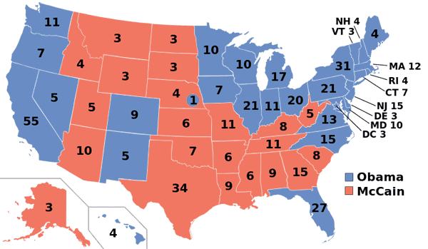
Presidential Election Maps from 1968 to 2012
Listed here are the presidential election maps for each the past eleven elections spanning 1968 to 2012. The maps show the breakdown of electoral college votes by state.

Twitter Map of the Last One Million Tweets
Want to see where the most recent one million geolocated tweets were posted from? The One Million Tweets Twitter map ...

Help Classify Images of Hurricane Sandy Damage
Volunteers are needed to classify images of Hurricane Sandy to help FEMA. The site is using open source image sorting ...
The GIS Career, Revisioned
GIS tools and software applications are becoming more intuitive, more user friendly. There is a mindset that is slowly being ...

Where is the Phrase “80% of Data is Geographic” From?
Those that work in GIS data have probably heard the phrase "80% of data is geographic". What is the origins of this phrase, and is it true?

Mapping Hurricanes
Information about embedable hurricane maps, historic hurricane tracks, and the top list of most damaging hurricanes from NOAA.

Baseball Maps and GIS
So how do cartography and baseball mix? Check out these interesting examples of baseball maps.

The Many Modes of Google’s Street View Program
Google’s street level imagery gathering is an enormous data collecting effort. Street View launched in May of 2007 and Google ...
Dos and Don’ts of Web Map Design
The proliferation of easy to use tools and web services has brought web mapping a long way from its origins. ...
Basic Geographic Concepts
Listed here are the basic geographic concepts for geographic understanding and inquiry. When looking at the geography of an area, ...
What Can You Do With GIS?
As well has having significant application in the worlds of business and commerce and natural resources the largest pool of ...
Geographic Analysis with GIS
The vast majority of information present in the world has some form of spatial element connected with it. A geographic ...
GeoSocial Interactive Map for Transportation Project Planning
This week a spectacular conference aimed towards transportation professionals is being held in Los Angeles called Rail~Volution. The aim of ...
SDTS – GIS Data Standard
SDTS stands for Spatial Data Transfer Standard. SDTS was a standard for transferring earth-referenced spatial data across disparate computer programs. The U.S. ...
GIS Skills
What skills are needed to be a successful GIS professional? Broken down by category, listed here is an in progress ...
Geoarchaeology
Geoarchaeology uses geospatial technologies such as GIS in combination with human, physical, and environmental concepts pulled from Geography and Geology.
How to Cite GIS Materials
How do you cite GIS materials such as map, GIS data, and GIS software? Listed here are examples on how to cite GIS work.

Aerial Mapping with Balloons, Kites, and Pigeons
While aerial photography today is most commonly captured via an airplane fitted with cameras, aerial imagery in the past required more inventiveness with photographers using balloons, kites, and pigeons.

Gretchen Peterson | Profiles From the Geospatial Community
Gretchen Peterson is a well-known geospatial professional who has run her own GIS consulting firm, Peterson GIS, since 2001.

Time and GIS: Ways of Representing Time on a Map
Spatialtemporal visualization are ways to illustrate changes in an area over time on a map. The famous geographer Immanuel Kant maintained that geography was the study of knowledge in a location, while history was the study of knowledge in time. This article explores different cartographic methods of showing changes in time over space on a map.
Hurricane Isaac Mapped
Projected to make landfall tonight at the southwest pass of the Mississippi River, a recently reclassified Hurricane Isaac has a lot ...
Excel Mapping with ArcGIS Online
Esri recently debuted the availability of Esri Maps for Office, a new component of its ArcGIS Online service that allows ...
Geography of Ancestry
What’s your geographic ancestral origin? A team of researchers from Tel Aviv University (TAU) and University of California, Los Angeles ...