
Caitlin Dempsey
Making Maps With Excel
There is a huge amount of untapped geographic information stored within Microsoft Excel spreadsheets. With over one billion users of the popular spreadsheet software, that is a lot of data waiting to be mapped out. That said, the capability of mapping out that geographic data doesn't necessarily need to be done through an external desktop GIS software application. There are a few solutions on the market that provide both free and cost-based mapping solutions that operate directly within Excel.
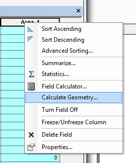
Calculating Polygon Area in ArcMap
Here are the steps for calculating the area of a polygon using ArcGIS.
What Do GIS Professionals Make: GIS Salary Surveys
What are the average salaries for a GIS Analyst, GIS technician, or GIS manager? Finding out that answer depends on a variety of factors from the industry the job is located in, years of experience, and education level of the GIS employee. Salaries also vary greatly by region/ The best way to get an estimate as to your earning power based on your location, experience, and field of interest is through GIS salary surverys.

Map Theft and Map Thieves
As with most objects that carry a potentially large price tag, rare and valuable maps have been subjected to theft ...

Geography of the Olympic Rings
The interlocked Olympic rings were meant to symbolize the Olympics' universality and to promote international harmony.

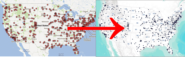
Where are the GIS Jobs? A Look at the GIS Job Market in the United States
The best way to answer where GIS jobs most frequently occur is to map out the location of GIS related jobs to see where, geographically within the United States employers are hiring.
How to Convert a KML File into an ArcGIS Compatible Format
This quick tutorial shows you how to convert a KML file so you can add it to ArcGIS.

GIS Guide to Public Domain Data
Esri Press has released a new book called The GIS Guide to Public Domain Data.
Armchair Geography
Geospatial technology has allowed users the ability to travel the world without ever leaving home. Users can explore the world, ...

Map as Art
There are many amazing examples of artists who turn to cartography and geography for inspiration. Whether through the lens of ...

Making Maps with Google Fusion Tables
Learn about making maps using Google Fusion tables.

Spatial Unmapped
Geographic maps aren't the only means by which to communicate spatial information.

How To Make Area Cartogram Maps in ArcGIS
If you have data with disparate values between areas, making an area cartogram is an effective way to map out those values. This article provides a tutorial on how to make area cartogram maps using ArcGIS.

Arkansas – Geography and Geology
Individuals in the U.S. don’t have to travel very far to find topographical change. We are surrounded by a variety ...

Interactive Maps of Billionaires
Three interactive maps showing the locations of billionaires around the world.
Geography of Billionaires: Mapping Nationalities and Residency
Forbes recently released an updated list of the world’s billionaires. The listing contains the ranking for 1,226 individuals and families ...
Geography of Billionaires: Total Counts of the World’s Billionaires by Country for Residency and Citizenship, and by City
This article contains the tables covering the statistics used in the Geography of Billionaires: Mapping Nationalities and Residency.

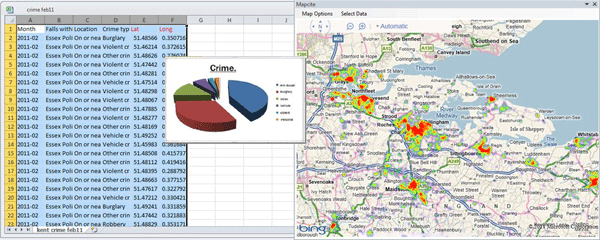
Crime Mapping and Analysis
The advent of easy-to-use GIS applications has allowed crime mapping and analysis to flourish within law enforcement agencies.

Area Cartogram Maps Explored
Area cartogram maps are maps of non-absolute space where the areal extent is in proportion to some measured value. Cartogram ...

GIS Skills and Landscape Architecture Education
The March 2012 Landscape Architecture Magazine revealed that while GIS is crucial for large-scale land planning, some landscape architecture schools do not require students to learn geospatial technologies.

Using GIS to Showcase College Acceptance
Every June, my local paper is filled with the local private school announcements containing lists and lists and lists of ...

Mapping Emancipation Events during the Civil War
"Visualizing Emancipation," the first interactive map showing the end of American slavery during the U.S. Civil War, has been launched by the University of Richmond’s Digital Scholarship Lab in partnership with geospatial analysis (GIS) software development company Azavea.
Titanic Mapping
April 15th marks the 100th anniversary of the sinking of the Titanic in the North Atlantic Ocean. Esri has created ...
Envisat Satellite Malfunctioning
Envisat, the European Space Agency’s (ESA) earth observation satellite, has stopped functioning properly. Communication with the satellite was lost on ...
GIS and Sustainability Efforts
GIS continues to grow in several areas that will enable it to be an essential tool in designing the sustainable buildings of the future.