
Caitlin Dempsey

GIS on the Mac
One of the most popular options for running GIS software directly within the Macintosh OS environment is QGIS.
Best of GIS: Notable 2011 Geospatial Happenings
It’s been a very long time since I’ve done a “best of GIS” year end review. Listed below are ...
Sample Esri Technical Exam Questions
Esri is now offering sample questions for Esri’s ArcGIS Desktop Exams. The sample questions are accessible from Esri’s Training page. ...
Unique Geography Themed Gifts
If you're looking for Geography themed presents that go beyond atlases, books, and GPS related products, there are some fun and creative options out there.

New Global Elevation Data Available: Global Multi-resolution Terrain Elevation Data 2010
NGA and USGS revised and improved their global elevation model.

Animation of Southern Lights (Aurora Australis)
This animation of the Southern Lights was recorded on September 11, 2005, four days after a solar flare sent an ionized gas of protons and electrons known as plasma towards the earth.

Online Mapping Sites
Web mapping is now vital to most people, providing virtual geography and driving directions on a daily basis.
Nokia’s Crowdsourcing GIS Effort
Nokia recently launched Map Creator (in beta), tossing its hat into the crowdsourcing GIS ring. While the announcement proclaims, “We’ve ...
Geosk: GIS Data as a Service (Daas)
Whats is Geosk and what does it mean for GIS data delivery? Scott Robinson, Director, Global Data Products at Pitney Bowes Business Insight, explains what Geosk means for GIS Data as a Service (DaaS) and how cloud computing can be used to delivery GIS data online.

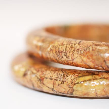
Gifts for Geographers and GISers
If you're trying to figure out the ideal gift for the GISer or geographer on your list, check out these great ideas for your Christmas and holiday gift shopping.

Explaining How Dark Sky Works
Dark Sky is a short term weather predictor protoype for iOS devices (more about the developers efforts to turn this ...

Global Navigation Satellite Systems
Few tools have helped change and improve data collection within the field of Geographic Information Systems (GIS) more than Global Positioning System (GPS).

Understanding the Earth’s Gravity with ESA’s Swarm Satellites
The European Space Agency will be launching three satellites next year with the objective of studying the earth's gravity.
Updated 3D Global Topo Data from NASA
Based on measurements from NASA’s Terra spacecraft, a new 3D topographic map has been released as a joint effort by NASA ...

Google MapsGL
GoogleMapsGL which combines Google Maps and Web Graphics Library (WebGL) brings 3D graphics to web browsers without the need to install 3D software.
Detecting Surface Change and Avalanche Mapping
Due to the precise measurements take can be taking from InSAR, changes in land movements can be detected as small as a few millimeters.
Making Maps with R
R language is a commonly used programming language and open source software that can be utilized by statisticians for statistical ...
What is Geodesign?
Recent progress with the use of technology to analyse data from various sorts to a very fine level of granularity ...
WhatWasThere – Augmented Reality
WhatWasThere is an augmented reality application that features a growing online database of geolocated historical photos. You can search for photos ...
Urban Heat Island Analysis
Remote sensing methods are being used to monitor thermal radiation in European cities. Hardscape surfaces such as roof tops and ...
Conservation Biology and GIS
Conservation biologists have come to recognize the importance of GIS in their discipline. Geographic Information Systems (GIS) have become a ...
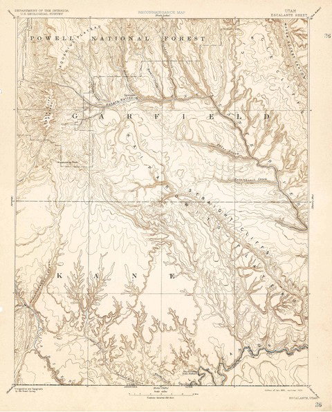
Over 120 Years of Mapping History Online
The USGS Historical Topographic Map Collection currently makes over 98,000 maps dating as far back as 1884 available to the public.

Ten Things to Consider When Making a Map
Here are ten common considerations that all cartographers should incorporate as part of their map making process.
Geofencing
With all the location-based social media applications out there, it’s only logical that, in addition to being able to restrict ...
Geostationary
Geostationary satellites maintain a stationary position relative to the earth.