
Caitlin Dempsey
Paraná River
The Paraná River runs 3,030 miles through Brazil, Paraguay and Argentina. It originates at the junction of the Paranaiba and the Rio Grande rivers. ...
Mississippi River
The Mississippi River is the second longest river in North America. Bodies of water from 31 contiguous states drain into ...
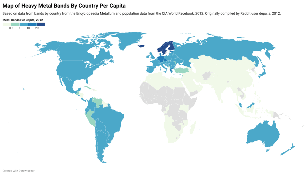
Interactive Map of Heavy Metal Bands By Country Per 100,000 People
Map and table showing where heavy metal bands are the most dense when compared against a country's total population.

Mapping the World at Night
Earth observation satellites are tracking nighttime lights around the world.

Mount Everest is the Biggest Mountain in England?
If you're one of six out of ten adults in the United Kingdom, apparently you believe that either Mount Everest, Snowdon, or Ben Nevis is the answer to "What's the Biggest Mountain in England?"
Ryan Resella | Profiles from the Geospatial Community
In this GIS interview, Ryan Resella discusses his experience as an inaugural fellow with Code for America last year and his outlook on geospatial technologies.
Moving Beyond Waiting for GIS’ Sally Field Moment
To say the least, I was mildly boggled when I noticed that Slashgeo.org was running a poll on “Is Geospatial ...

OpenStreetMap: Grassroots Mapping
OpenStreetMap was founded with the goal of creating and providing free geographic data to whoever wants it.

Distance Decay and Its Use in GIS
Distance decay is a phenomenon observed between locations or ethnic groups- the further apart they are, the less likely it is that they will interact very much. Distance decay theory in GIS can be used for other purposes such as the effects of time and distance on public transportation ridership, crime analysis, and health care.
Getting Started With QGIS: Open Source GIS
Quantum GIS is an open source GIS desktop software more popularly known as QGIS. QGIS 1.0 was first released in ...
Ultima IV Map Exhibition Preparation – GIS in Imagery Series
The Smithsonian American Art Museum is featuring an exhibition entitled The Art of Video Games which is set to run ...
What is Ethno Mapping?
Maps aren’t just intended for navigation. Though most people think of maps in terms of what kind of physical land ...

Google Ancient Places: Exploring the Geography of Ancient Places in Text
GapVis (Google Ancient Places Visualization) allows readers the ability to geographically explore text covering ancient places. The endeavor is backed ...

TileMill: Open Source Mapping Now for Windows
TileMill can now be used natively in Windows with the latest release. The release of TileMill 0.9.0 also includes a new plugin system: “TileMill ...

Where to Look for Historical Maps
The use of extracting data from old paper maps is growing in popularity as a method to understanding historical geography. ...

WorldMap: An Open Source Software Platform
Harvard’s Center for Geographic Analysis recently released WorldMap, an open source mapping application designed to make it easier for researchers to upload ...

Wind and GIS
GIS has many applications in wind mapping, analysis and modeling. Geographic data and modeling of wind performance can help site ...
GIS Industry Trends and Outlook
GIS industry trends gain be gleaned by surveys and other reports produced by market research companies. While most of these ...

New Baby Island in the Zubair Islands
A new island has been added to the Zubair Islands off the Yemeni coast as a result of volcanic activity that erupted on December 19, 2011.

National Forest Map and GIS Data
Josef Kellndorfer and Wayne Walker of the Woods Hole Research Center (WHRC) worked with the USGS and the US Forest Service over a six year period to create this forest map of the United States.
Caribbean Islands: the Greater Antilles
A Look at the geography of the Greater Antilles By looking at a map of the Caribbean we can easily ...
Essential Geography of the United States Mapped
Dave Imus is a well known cartographer who has specialized in highly detailed, hand annotated maps covering the United States. ...

Ice Mapping App for Smartphones
The European Space Agency has released a new iOS app for accessing ice data from the ESA's CryoSat mission.
Mapping Air Pollution
Pulling real time data from the city government of Madrid, Into the Air is a project led by Nerea Calvillo (along with ...
Open MapQuest
Google’s recent enforcement of Google Maps API usage, resulting in charges for those exceeding the stated free usage quotas, has ...

Historical Geography and GIS
Historical GIS is the use of GIS data to document the given geography of an area in history. GIS can ...