
GIS Data
This category contains introductory text about GIS data such as types of error in GIS datasets, types of GIS data (raster and vector), and metadata.

Mapping Soil Moisture from Space
Soil moisture might not be considered a critical factor to the health of our planet but a series of satellite ...

USGS Report on the Uses and Benefits of Landsat Imagery in Water Resources
The USGS recently published a report looking at case studies of Landsat Imagery use in water resource management within public ...

GIS Data of the World’s Wetlands
There are currently 2,185 sites worldwide that the Ramsar Convention considers to be wetlands of international importance representing over 208,597,750 hectares. GIS Data for Ramsar sites is available from Wetlands International.

Access CryoSat-2 Ice and Ocean Data Products
CryoSat-2 has been collecting data since its launch in 2010, allowing scientists to better understand changes in the thickness of polar sea ice, the elevation of the ice sheets that blanket Greenland and Antarctica, and mountain glaciers.

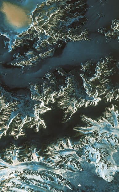
GIS Data of the World’s Glaciers
An international group of seventy scientists hailing from more than eighteen countries have created the first global datasets of the ...

NASA’s Global Precipitation Measurement
Water is essential for life on the Earth, and the supply of this precious liquid is constantly being recycled through ...

Overview of Public Health and GIS
This article provides an overview of the use of GIS as in public health. It includes a short history of its development as a tool in the field, explains how GIS is used, different data sources and how the privacy of sensitive health information is maintained. Examples of current research using GIS within the public health field are also provided.
First Satellite Images from Sentinel-1A
Launched on April 3 and reaching operational altitude on April 11, the first images captured by the European Space Agency’s ...

The ASTER Spectral Library – a True Monument of Remote Sensing Data
In the first part of this series, Cameron Windham from Apollo Mapping takes a look at the nuts and bolts of the widely-used ASTER Spectral Library.

Imagery and Its Use in GIS
Most imagery for use in GIS projects consist of satellite images or aerial photographs but it can also include, thermal images, digital elevation models (DEMs), scanned maps and land classification maps. This article examines imagery and how to effectively gather, store, process and interpret it for a variety of different GIS projects.
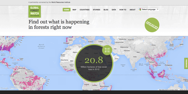
Global Forest Watch: A Real-Time Mapping Project
Data from Global Forest Watch, an online forest monitoring and alert system is now available via an online mapping platform. Users of this data portal can add maps, datasets, and applications to their forest projects and better analyze indicators of forest change.
Using Speed Data to Track the Movements of Vehicles
Researchers from Rutgers University have been testing out the theory that speed information matched against road topology provides enough information ...

LiDAR and the Archaeology Revolution
Through the use of LiDAR, archaeologists are now able to uncover more of the ‘lost’ New England of subsistence farming from the 1700s.

Predicting Natural Disasters and Humanitarian Crises through GIS
The National Geospatial-Intelligence Agency (NGA) wants to create a data-rich map with its proposed Project GeoAnalytics that takes into account not only the physical characteristics of certain locations around the globe but also include supplementary information about its people and the political situation.

The Role of High-Resolution Imagery and GIS in Flood Relief Efforts in Colorado
With flooding events in the United States, high-resolution imagery and GIS play a role assessing flood-related damages in order to assign and focus relief efforts.

Mapping Ship Logs
Ben Schmidt, who is an assistant professor of history at Northeastern University, has mapped out historical shipping routes.

Mapping the Earth’s Polar Regions
In order to better understand the Earth’s Polar Regions, improved maps are continually being developed. The latest of these is a set of high-quality satellite images of Antarctica from the Polar Geospatial Center. The PGC has made them accessible through several web-based mapping applications.

Creating a Sustainable Space Environment Using Satellite Sails
European Space Agency scientists are pioneering sustainable space technology through satellite innovation.

Earth Wind Map
Last year, Fernanda Viégas and Martin Wattenberg of the site Hint.FM pulled near real-time data from the National Digital Forecast Database, to ...

Satellite Mapping of the Great Barrier Reef
For the first time, a complete bathymetry high resolution (30 meters) bathymetry map is available of the Great Barrier Reef. The map was produced by remote sensing company, EOMAP using satellite data and imagery.

Mapping All the Swimming Pools in Los Angeles
Los Angeles is known for its nearly constant sunshine and warm climate so it’s no surprise that the region contains ...

New Detailed Maps Show Changes in Earth’s Forests
Deforestation, the clearing and removal of the Earth’s forests, has been one of the major environmental threats to the globe ...
Free and Open Access to Sentinel Satellite Data
The European Space Agency (ESA) has announced that free and open access to Sentinel satellite data will become available during ...

National Safe Routes to School Program Calls for GIS Initiatives
The National Safe Routes to School program (SRTS) was primarily created to promote safety for children who walk and bike ...

ZIP Code Data is “Commercially Sensitive” Per the US Postal Service
Robb Shecter of the Weblaws.org site wanted to map out restaurant health inspections in Multnomah County, Oregon as part of his ...

Automating Extracting GIS Data from Scanned Maps
The New York Public Library Labs (NYPL Labs) has posted on Github the code to its open source map-vectorizer project. NYPL ...