
Biogeography
Biogeography is the study of the distribution of animals.

Tracking Ocean Currents With Seabirds
A group of researchers wanted to test if drifting seabirds could offer a novel way of collecting data about sea current velocity and direction.

Mapping the Last Wilderness
An international group of scientists led by James E. M. Watson and James R. Allan mapped the world’s remaining terrestrial wilderness in 2016.

More Animals Are Becoming Nocturnal Thanks to Human Activity
Researchers from UC Berkeley undertook a study that looks at the effect of human activity on the daily activity patterns of wildlife.
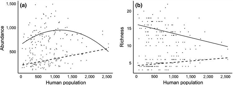
Study Finds a Lower Abundance of Songbirds in Poorer Urban Areas in England
A recently published study looked at the spatial relationship between people and birds across urban areas in Southern England in order to understand patterns of abundance and species richness among birds in populated areas.

King Penguins Like to Maintain Just the Right Amount of Personal Space
Researchers found a liquid-like spacing in King penguin colonies is the result of a balance between territorial pecking and a need to form in large groups as protection against predators.

Marine Heatwaves are Becoming Longer and More Frequent
Researchers, using satellite observations, have found that marine heatwaves are becoming more frequent and longer lasting.

Debris from the 2011 Japanese Tsunami Carried Almost 300 Marine Species Across the Pacific Ocean
A group of researchers inventoried what marine species traveled across the Pacific Ocean between 2012 and 2017 as the result of a biological rafting event created by the 2011 Japanese Tsunami.

Sensing Longitude Among Birds
A study has shown that the Eurasian reed warbler is able to sense magnetic declination and use that information to determine their migratory flight path.

Animated Map Shows Animal and Bird Migrations
Scientists modelled animal migrations based on global climate change patterns and created a map that showed potential future migrations of different species in North, Central, and South America.

Tree Migration Direction Affected by Climate Change
Ecologists have found that climate change, as it changes precipitation levels and temperatures, is causing trees to grow in different locations than they have traditionally taken root.

By Using High-resolution Satellite Imagery to Survey Drylands, Researchers Boosted Estimates of Global Forest Cover by 9%
Researchers, using high-resolution satellite imagery, have discovered there is about 40-47% more forest cover in dryland biomes than previously thought.

Adonis: Europe’s Oldest Known Living Tree
A 1,075-year old pine tree known as Adonis is believed to be the oldest tree in Europe.

Great Elephant Census
The group called Elephants Without Borders has recently finished a two-year survey of African elephants across the entire continent, known as the Great Elephant Census (GEC).

Online Atlas Tracks Ecologically Troubled Areas of the World
A new atlas produced by Richard Weller from the University of Pennsylvania tracks how urban sprawl and human activities are endangering bioregions on Earth.

Polar Bears Can Be Found in Which Countries?
Learn about which countries contain the habitat range of the polar bear as well as a map of the polar bear habitat.

Habitat Fragmentation: A Multi-Scale Approach detailing its lasting impact on Earth’s ecosystems
An analysis performed at multiple spatial and temporal scales argues that destruction and degradation of natural ecosystems are the primary cause of global declines in biodiversity.

Adapting to Live in a Hypersaline Environment
In their field work, the Iranian and French researchers encountered a Günther’s sea snake in the Persian Gulf, beyond what was thought to be its geographical range.

Mangrove Ecosystems’ Importance and Vulnerability to Climate Change
Scientists in Australia have discovered that mangrove ecosystems in Queensland are dying at rates that have never been seen before.

Life Persists Around Chernobyl
Researchers are studying radiation's impact on wildlife and habitats in Chernobyl's exclusion zone.

Negotiations Underway at United Nations for Marine Protected Areas
The United Nations is currently developing regulations for ocean waters beyond national boundaries and exclusive economic zones, extending beyond 200 miles.

Using Clouds to Map Ecosystem Boundaries
Researching clouds and their impact on ecosystems and species could help researchers find an entirely new way to see the Earth. By looking at clouds, researchers can add a layer of evidence to existing theories and practices of conservation of land and animals.

How Climate Change is Affecting the Forests of the Sierra Nevada
Climate change is causing certain key species in the Sierra Nevada mountains to change where they are growing according to a study published by the journal California Fish and Game.

Geography of Microbiomes
Researchers have determined that geography seems to be the most influential factor in determining what kinds of microbial life would be found in a variety of local office settings.

Using Song Meters to Count Frog Populations
Conservationists use cameras, acoustic sensors, and audio recording devices to count the red-legged frog in Watsonville Slough, Santa Cruz County.

How Unleashing Two Dams Extended Washington’s Coast
The removal of two dams along the Elwha River in the Olympic Peninsula caused an expansion of the coastline of Washington and created a massive estuary.

Caño Cristales, the Rainbow River
The river Caño Cristales, is also known as the river of five colors for the vibrant path it winds through the Colombian landscape.