
deforestation

Small-scale Deforestation is on the Rise in the Amazon
Researchers analyzed forest loss rates across the entire Amazon between 2001 and 2014.

Deforestation Is Drying Up Atmospheric Rivers
Deforestation has a dramatic impact on climate, reducing evapotranspiration which feed atmospheric rivers.

Tropical Forest Degradation Means More Carbon Dioxide is Released into the Atmosphere Than is Absorbed
Satellite images targeting areas of tropical Asia, Africa, and the Americas have shown that some tropical forests are dispelling more carbon than they are taking in.

Tracking Deforestation by Measuring the Distance to the Nearest Forest
Using satellite images, researchers established a method of calculating the distance between any point in the continental United States and the nearest forested area.

Geo Quiz: Name the Human Activity Visible from Space
This geography quiz features ten satellite images each showing an anthropogenic activity. Can you figure out what the human activity shown on each image is?

Using Remote Sensing to Understand the Correlation Between Deforestation and Forest Fires
MAAP has used remote sensing to discover a correlation between deforestation and forest fires in Tampbopata, Peru.

A Conservation-Based Future in Colombia
By properly including indigenous and impoverished peoples in the new economy and securing communal land rights in the forests, as well as fostering soil recovery in areas of coca cultivation and managing resource extraction, Colombia can move into a more equitable and environmentally sustainable future.

Using LiDAR to Show How Native American Depopulation Impacted Forests in the United States
Researchers have used LiDAR to understand the impacts of Native American population decline on forest fires in the United States.

Cloud Computing Used to Analyze Landsat Imagery and Detect Deforestation
Landsat, NASA’s longest running initiative for the acquisition of Earth imagery, has generated nearly 50 trillion pixels of data by capturing one image per season, of every place on Earth, for the past 43 years, providing a treasure trove of data for researchers.

Mapping Carbon in the Amazon
In order to produce the most detailed carbon maps of the Amazon, researchers turned to remote sensing, specifically satellite imagery and LiDAR.

Putting the Trees Back on the Map: How GIS is Helping Reforest South America
GIS is being used in creative ways – including covert spy tracking of illegal logging deep in the Amazon – to help put and keep trees back on South America’s map. The simplification of tools and availability of web systems has empowered technicians, NGOs, and governments alike to address corruption and illegal logging with transparent map-based monitoring.
How Deforestation Affects Physical Geography
Deforestation is a problem we are likely all familiar with, even in passing. We drive or walk by small or ...
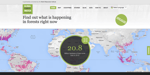
Global Forest Watch: A Real-Time Mapping Project
Data from Global Forest Watch, an online forest monitoring and alert system is now available via an online mapping platform. Users of this data portal can add maps, datasets, and applications to their forest projects and better analyze indicators of forest change.

New Detailed Maps Show Changes in Earth’s Forests
Deforestation, the clearing and removal of the Earth’s forests, has been one of the major environmental threats to the globe ...