
Esri

Mapping the Impacts of Climate Change in California
A group of Stanford students taking a biology class entitled Geographic Impacts of Climate Change: Mapping the Stories have mapped out news and journal articles about climate change in California.

Views From the 2014 Esri International User Conference: GIS In Imagery
Photographer Kristina Jacob shares moments she captured from the 2014 Esri International User Conference that was held in July in San Diego, California.

Esri Releases Explorer for ArcGIS for Mac OS
Data viewer from Esri for MacOS which offers limited functionality to "access maps, search for and visualize data."

Explore Maps of the United States from 1884 to 2006
The U.S. Geological Survey and Esri are working together to make over 178,000 maps of the United States available to the public via an ...

How to Share ArcMap (.mxd) Files
Learn how to set up your GIS data and symbol sets so that you can share ArcMap .mxd files with others.
ArcGIS Explorer vs. ArcGIS Online: A Side by Side Comparison
Two of Esri’s principal GIS viewing products, ArcGIS Explorer Desktop and ArcGIS Online, offer a variety of tools for both business and personal use. Tracey Dash takes a look at some of the key differences between the two programs.

Add ArcGIS Online Maps to Your Wordpress Blog
A new plugin has just been released that gives those using Wordpress the ability to embed maps from ArcGIS Online ...

Mapping Hurricanes
Information about embedable hurricane maps, historic hurricane tracks, and the top list of most damaging hurricanes from NOAA.
Excel Mapping with ArcGIS Online
Esri recently debuted the availability of Esri Maps for Office, a new component of its ArcGIS Online service that allows ...
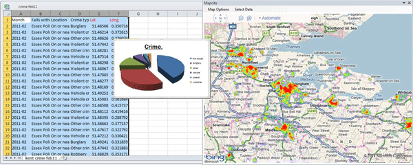
Making Maps With Excel
There is a huge amount of untapped geographic information stored within Microsoft Excel spreadsheets. With over one billion users of the popular spreadsheet software, that is a lot of data waiting to be mapped out. That said, the capability of mapping out that geographic data doesn't necessarily need to be done through an external desktop GIS software application. There are a few solutions on the market that provide both free and cost-based mapping solutions that operate directly within Excel.
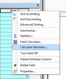
Calculating Polygon Area in ArcMap
Here are the steps for calculating the area of a polygon using ArcGIS.

How To Make Area Cartogram Maps in ArcGIS
If you have data with disparate values between areas, making an area cartogram is an effective way to map out those values. This article provides a tutorial on how to make area cartogram maps using ArcGIS.
Titanic Mapping
April 15th marks the 100th anniversary of the sinking of the Titanic in the North Atlantic Ocean. Esri has created ...
Ryan Resella | Profiles from the Geospatial Community
In this GIS interview, Ryan Resella discusses his experience as an inaugural fellow with Code for America last year and his outlook on geospatial technologies.
Sample Esri Technical Exam Questions
Esri is now offering sample questions for Esri’s ArcGIS Desktop Exams. The sample questions are accessible from Esri’s Training page. ...
Ice Thickness and Ocean Maps
Two new datasets have been announced. The ESA unveiled its new ice thickness map at the Paris Air and Space Show. ...

Views from the 2010 Esri UC
GIS professional and photographer Kristina Jacob shares photos from the 2010 Esri International User Conference
Why ArcView 3.x is Still in Use
While Esri is pushing migration to its ArcGIS suite of GIS software, some GIS groups continue to use ArcView 3.x.

How to Label More Than One Field in ArcMap
You can easily label more than one field of a layer in ArcMap with Visual Basic script.
Basic Guide to ArcXML
With the release of ArcIMS, ESRI’s map server software, GIS users were also introduced to ArcXML. ArcXML is ESRI’s flavor ...

Notes from the Conference – ESRI’s 21st Annual User Conference
The 21st annual ESRI User Conference is being held this week in San Diego, California with over 11,000 GISers representing 110 countries in attendance.

The Geography Network
Esri launched the Geography Network as a collaborative system for sharing digital geographic information on the internet.
How to Select Ridgelines From a DEM Using Spatial Analyst
Selecting out ridgelines from a DEM using ArcView 3x’s Spatial Analyst extension is pretty straightforward. These steps assume the initial ...