
GIS tutorial

How Can Looking at Hurricane Tracks Help to Understand Them?
Robert Lang's GIS tutorial employs public hurricane mapping sites to comprehend hurricane tracks, with exploratory questions incorporated within the tutorial steps.
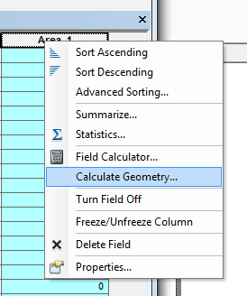
Calculating Polygon Area in ArcMap
Here are the steps for calculating the area of a polygon using ArcGIS.

Inequality Tutorial Using Instant Atlas
This tutorial looks at how the Instant Atlas map viewer allows the user to compare different areas in the UK.
How to Convert a KML File into an ArcGIS Compatible Format
This quick tutorial shows you how to convert a KML file so you can add it to ArcGIS.

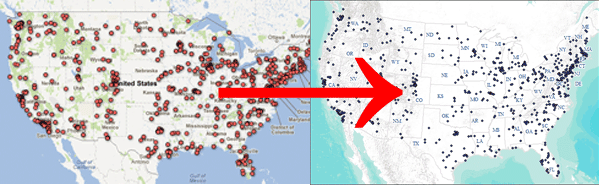
How To Make Area Cartogram Maps in ArcGIS
If you have data with disparate values between areas, making an area cartogram is an effective way to map out those values. This article provides a tutorial on how to make area cartogram maps using ArcGIS.

How to Install ArcView 3.x on Windows 7
This article contains two different solutions for getting ArcView 3.3 to run on Windows 7.
Digitizing Using ArcGIS
This tutorial reviews basic digitizing using the editor toolbar in ArcGIS desktop.
Clip Analysis using ArcGIS Desktop
The video tutorial below demonstrates how to use clip analysis using ArcGIS 9.2.
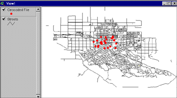
Geocoding Primer
This tutorial explains how to geocode using Esri's ArcView 3.x GIS software.