
GIS tutorial

How to Use ArcGIS Pro for Supervised Classification
This ArcGIS Pro tutorial provides a step-by-step guide for performing supervised classification on Landsat 8 imagery using remote sensing and GIS techniques.

How to Use ArcGIS Pro to Estimate Soil Erosion from a Catchment Basin
This lesson shows how to use spatial data science and remote sensing techniques in ArcGIS Pro to predict soil erosion in a catchment area using the Universal Soil Loss Equation (USLE).
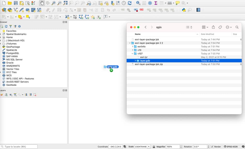
How to Import an Esri Layer Package in QGIS
While QGIS cannot directly read an Esri layer package, there is a simple technique to unpack the file and import it into this GIS software.

How to Use ArcGIS Pro for Fire Risk Mapping
Tutorial showing how to map fire risk for a region with slope, elevation, aspect, and land use data in ArcGIS Pro.
How to Create a Time-lapse of Satellite Imagery With Google Earth Engine and Streamlit
Qiusheng Wu explains how to make a 60-second satellite timelapse of any location on the globe.
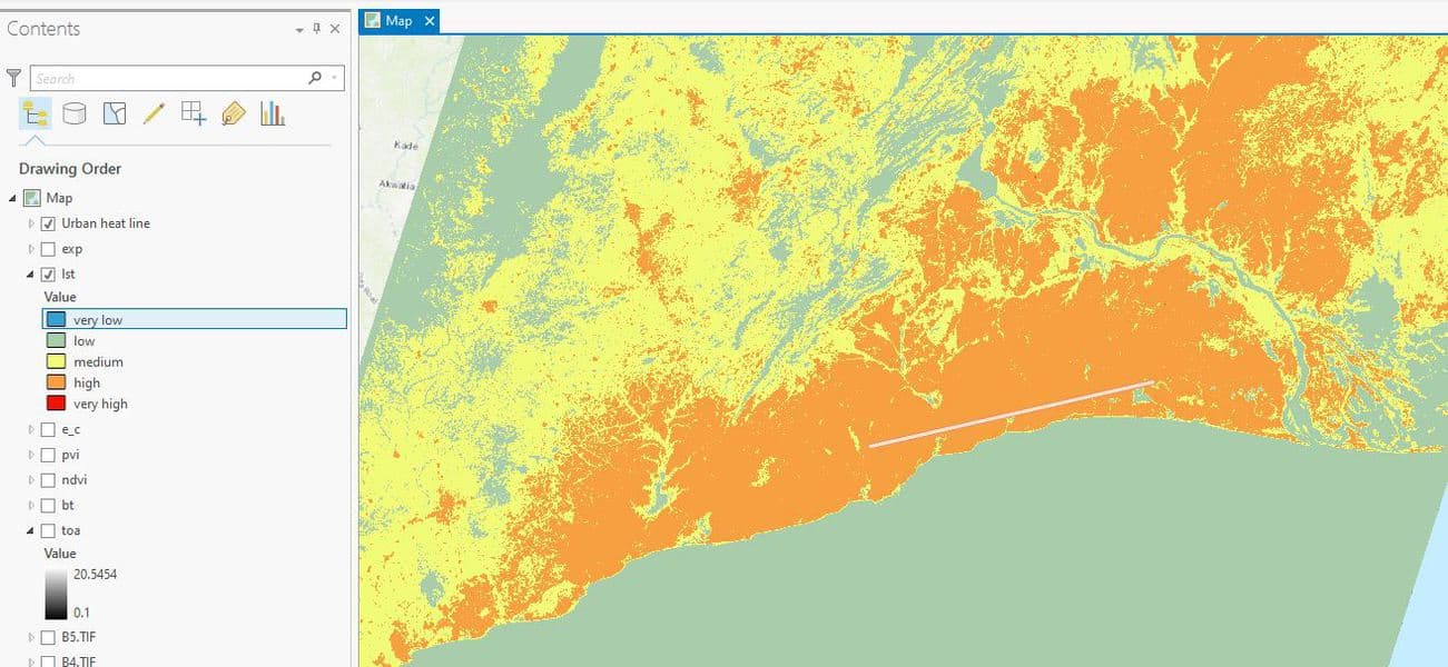
How to Use ArcGIS Pro to Map Urban Heat Islands
This ArcGIS Pro tutorial demonstrates how to assess urban heat in a region.
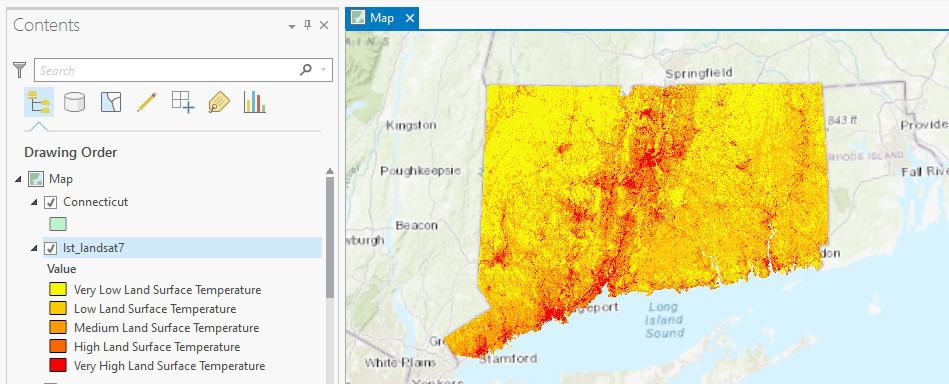
How to Use ArcGIS Pro to Calculate Land Surface Temperature (LST) from Landsat Imagery
This ArcGIS Pro tutorial utilizes spatial data science and remote sensing techniques to calculate land surface temperatures using Landsat imagery.

How to Use ArcGIS Pro to Assess Landslide Susceptibility
This tutorial explains how landslide susceptibility can be assessed using ArcGIS Pro.

Building a Model with ArcGIS ModelBuilder Saves Time
Emmanuel Jolaiya shows users how to use ArcGIS ModelBuilder to develop a model for for analyzing and manipulating GIS Data.

How to Add Leader Lines to Labels in QGIS
The release of QGIS version 3.10 brought with it the native capability to add leader lines to labels.
How to Change the Projection of a Shapefile Using QGIS
If you know your shapefile's beginning coordinate system or projection, you can export the data using QGIS.

Tutorial: Introduction to Geospatial Analysis in R
Explore the "Introduction to Geospatial Analysis in R" tutorial for lessons on importing files, layer management, and making maps.

How To Use the Equal Earth Projection With QGIS on the Mac
Here are a few short steps to set up the Equal Earth map projection in QGIS.

How to Make a Tile Grid Map Using Google Sheets
This tutorial provides instructions on how to create a tile grid map using Google Sheets.

How to Change the Label Language When Using Natural Earth’s Quick Start QGIS Files
One quirk with the version 3 of the Natural Earth quick start kit .qgs file is that when you load it in to a session of QGIS, it can display labels in a language you weren't expecting.

How to Get the Map View in QGIS to Resize Properly on a Mac
One Mac OS specific bug is the map view canvas doesn't fill the available space in QGIS 3.x versions. Learn how to fix this.

How to Populate a Cell with the ZIP Code Based on an Address in Google Sheets
You can set up a simple function in Google Sheets to be able to populate a separate column with ZIP code dat based on address data.

How to Add a Map from Mapbox to QGIS
This tutorial will show you how to take a map style you have created in Mapbox and load it into a QGIS session.

How to Save a Selection as a New File Using QGIS
Learn how to save a selection from a GIS dataset to a new GIS file using QGIS with this quick video tutorial.

Dress Up Your QGIS Install With this Whimsical Plugin
The QGIS hats plugin is a bit of fun that accomplishes no other purpose than to add a hat to the QGIS icon.

These Two ArcGIS Books are Free from Esri
Esri offers two free ArcGIS books: '10 Big Ideas about Applying The Science of Where' & 'Instructional Guide for The ArcGIS Imagery Book'.
How To Make a Map From Open Data Using a Spreadsheet
Jonathan Goldman explains in this tutorial how to extract an open data feed from a civic data portal and pull it into Google Sheets, and then map it quickly using Geosheets.
How to Map a Single Set of Coordinates Using QGIS
Here are the steps you need to follow if you want to map a single set of coordinates with QGIS.
How to Convert a Selection into a New GIS Dataset Using QGIS
Here is a step-by-step tutorial on how to convert a geographic selection from one GIS dataset into a new GIS file using QGIS.

Creating Administrative Choropleth Maps Using R
Learn how to create Administrative Level 1 Choropleth Maps in R with this tutorial by Ari Lamstein.

How to Add XY Coordinates to a File in ArcGIS
Outlined in this article are the steps to take in order to add X Y coordinates to a field in the attribute table using Esri's ArcGIS software.