
One thing that the fires raging in the US West Coast states have shown is that far better planning is needed before large, megafires even develop.
New tools that have been developed could now be used to limit the spread of these fires and plan before events get out of control. Furthermore, these tools also allow other environmental benefits as well as enabling us to get to know tree species around us.
The global tree count
In a recent publication, researchers estimated that there are approximately 3.04 trillion trees on Earth. [1] This massive number underscores the planet’s rich and diverse forest ecosystems.
More than a third of the world’s trees are concentrated in tropical and subtropical forests, regions known for their dense vegetation and biodiversity. These areas, such as the Amazon rainforest and the Congo Basin, are critical not only for the global carbon cycle but also for maintaining biodiversity. The concentration of trees in these regions highlights the importance of protecting these forests, as they play a crucial role in regulating the Earth’s climate and supporting countless species of plants and animals.
Mapping every tree on Earth
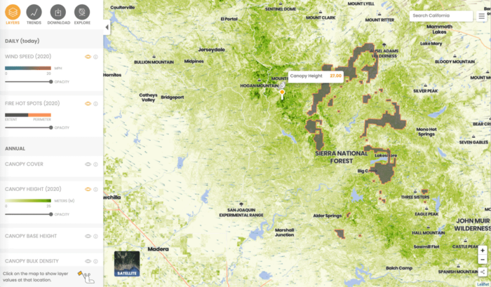
Although we still do not have a detailed map that can accurately show every tree on the Earth, recent developments now make it possible and more likely that we will in the near future. The California Forest Observatory[2], created by Salo Sciences, has applied a new artificial intelligence tool that maps every tree in California.

Combining satellite data and artificial intelligence to map trees
The tool also uses satellite data and combines imagery and machine intelligence to recreate every location and tree for the state. Data is pulled from satellites and Lidar (light detection and ranging) data from aircraft. The artificial intelligence allows trees to be reconstructed from this data so that tree height can be determined.
The role of detailed forest maps in fire prediction
Scientists have stated that one of the biggest obstacles in knowing how fires could spread is the lack of detail in forest maps. By mapping every tree, scientists can better predict the speed and direction fires may spread.
Existing tools mainly use older satellite data, which often do not clearly show every tree and are often out of date. Tree maps also need to be updated frequently.
The new tool will update at the end of the fire season each year or even sooner. Perhaps just as important, forestry services can use the information to plan their forest management strategies before the fire season to mitigate the impact of fires.
The problem of excess fuel in forests
The current problem is there is too much fuel, particularly undergrowth, that is creating the large fires. Normal fire suppression has often led to this undergrowth not burning, leading to more growth that creates the fuel for potentially larger fires.[3]

Earlier efforts in tree mapping
The work by the California Forest Observatory mirrors earlier efforts, such as by Descartes Labs, which used high resolution satellite data that also used machine learning to inform and reconstruct tree areas so that every tree could be mapped. In fact, with this tool, it is possible to create a tree map using UAV or higher resolution aerial photographs.
This effort was initially done with mapping so-called urban forests, that is mapping trees in urban regions, to help manage these trees so that they provide various environmental and social benefits to cities.
Potentially, the tool could be expanded to map other regions, including non-urban areas, to develop more reliable tree maps that allow one to map every tree.[4] Other countries are also attempting to map their trees in greater detail, focusing on mapping all trees for environmental, particularly in the fight against climate change, and fire suppression reasons.
Tree mapping initiatives in the UK
In the UK, Bluesky uses Lidar and thermal aerial data that allow detail on every tree more than 3m in England and Wales to be mapped.[5] There are also mobile applications that lets users know about every tree around them, including in urban neighborhoods.
Mobile applications for tree identification
One tool is TreeTalk, which has become particularly popular since the pandemic as users stay increasingly near where they live on a day-to-day basis. The tool informs about the species for trees mapped, giving users a sense of what types of trees are around them.[6]Currently the tool works well only in London but similar initiatives are found in cities in North American and Europe.

The importance of detailed tree mapping
The importance of mapping trees in detail has become evident with the large wildfires raging in the Western US states. Many tools exist that now allow users to have maps of specific regions and all trees in those areas.
This is a good first step but more will be needed as wildfires and other environmental challenges are proving to be global problems. These tools offer hope that they can be scaled to a larger extent, where perhaps in the near future we will see global scale maps that allow us to see nearly ever tree of the over 3 trillion trees estimated on this planet.
References
[1] For more on research demonstrating an approximation for the total number of trees on Earth, see: Crowther, T.W., Glick, H.B., Covey, K.R., Bettigole, C., Maynard, D.S., Thomas, S.M., Smith, J.R., Hintler, G., Duguid, M.C., Amatulli, G., Tuanmu, M.-N., Jetz, W., Salas, C., Stam, C., Piotto, D., Tavani, R., Green, S., Bruce, G., Williams, S.J., Wiser, S.K., Huber, M.O., Hengeveld, G.M., Nabuurs, G.-J., Tikhonova, E., Borchardt, P., Li, C.-F., Powrie, L.W., Fischer, M., Hemp, A., Homeier, J., Cho, P., Vibrans, A.C., Umunay, P.M., Piao, S.L., Rowe, C.W., Ashton, M.S., Crane, P.R., Bradford, M.A., 2015. Mapping tree density at a global scale. Nature 525, 201–205. https://doi.org/10.1038/nature14967.
[2] The California Forest Observatory can bee seen here: https://forestobservatory.com/
[3] For more on California Forest Observatory, see: https://www.fastcompany.com/90549160/this-tool-is-mapping-every-tree-in-california-to-help-stop-megafires.
[4] For more on this earlier tool used to map urban trees, see an earlier story: https://medium.com/descarteslabs-team/descartes-labs-urban-trees-tree-canopy-mapping-3b6c85c5c9cc
[5] More on Bluesky can be found here: https://www.bluesky-world.com/ntm
[6] For more on TreeTalk, see: https://www.treetalk.co.uk