
wildfires

Hydroclimate Whiplash: the Impact on California Wildfires
Rapid shifts between extremely dry and unusually wet conditions are reshaping California’s fire landscape by increasing vegetation growth, drying fuels, and contributing to more intense wildfires.

What Are pyroCbs? Understanding Wildfire Thunderstorms
Learn how pyroCbs form when extreme wildfires generate powerful thunderstorms capable of producing lightning, spreading smoke, and fueling new fires.

Geography of Giant Sequoias
Giant sequoias are one of the longest lived tree species, with the oldest giant sequoia living an estimated 3,400 years.

Study: More U.S. Homes Burn in Grassland and Shrubland Fires than Forest Wildfires
A new study in Science reports that in the United States, grassland and shrubland fires tend to be more extensive and burn more houses than forest fires.

Mapping Wildfire Movement
The Fire Events Data Suite is being used to map near real-time wildfire behavior including fire perimeters, active front, and total burned areas.

Wildfires in Canada
Canada's boreal forests are facing a strong start to the 2023 wildfire season in Alberta and British Columbia.

2023 Wildfires in the Western United States
So far in early August of 2023, the wildfire season in the western United States has not been as intense as prior years when a years-long drought was raging.

Causes of Wildfires in the United States
Every year, thousands of wildfires rage across the United States, consuming millions of acres.

Wildfire Smoke From Canada is Affecting Parts of the United States
Smoke from the June 2023 Canadian wildfires is affecting the Midwest and northern regions of the United States.

Early Wildfires in New Mexico
Wildfires in New Mexico are are starting earlier each year due to warmer and drier conditions.

The Wildland-Urban Interface is Growing in the United States
More people in the United States are moving from urban areas into more natural landscapes.

Review | Drought, Flood, Fire: How Climate Change Contributes to Catastrophes
"Drought, Flood, Fire: How Climate Change Contributes to Catastrophes" is written by a scientist who understands how to meaningfully inform his non-scientist readers.

2021 Wildfires in the U.S. and Canada
Climate change is causing wildfires to burn longer and more frequently in some northern latitudes.

Three of Colorado’s Wildfires are the Largest in Recorded History for the State
Widespread drought and heat waves are helping to fuel a record-breaking fire season in Colorado.

How to View Animated Satellite Imagery of the California Wildfires
Users can quickly make animations of the California wildfires using imagery from NOAA's GOES-West satellite.

Smoke from the California Fires Over the Pacific Ocean
NASA’s Terra satellite captured this image of smoke from the August Complex fire and other fires burning in California as it blows out over the Pacific Ocean.

Track Real-Time Air Pollution With this Crowdsourced Map
One way to track air quality at the local level is by visiting PurpleAir, an interactive map that pulls in crowdsourced data.
Smoke from Australian Wildfires Reaches Atmospheric Highs
Smoke from the 2019 wildfires not only impacted Australian population centers but drifted far into the atmosphere as well.

Satellite Imagery Shows Fire Damage to Australia’s Kangaroo Island
Like parts of mainland Australia, Kangaroo Island has been devastated by bushfires fueled by drought and intense temperatures.

View From Space: Australia’s Wildfires
The Moderate Resolution Imaging Spectroradiometer (MODIS) on NASA’s Aqua satellite acquired a natural-color image acquired this image of smoke rising from wildfires burning in New South Wales (NSW) and Queensland.
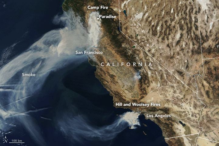
Smoke from the Camp Fire is Making Northern California Air Among the Unhealthiest in the World
The continual arrival of smoke from the Camp Fire has pushed cities in the northern California area to air pollution levels to some of the highest around the world.

Largest Fires in California’s History
In California, the officially hottest month on the record- July - was topped with the most severe wildfire season that Californians have ever witnessed.

A New Algorithm to Find Wildfires When It’s Cloudy
New technology called the Firelight Detection Algorithm, or FILDA, can help detect wildfires at night even when the skies are cloudy.

Fire Seasons Becoming Longer and More Frequent
Research on fire seasons indicates that around 25% of Earth’s vegetated surfaces now experience a longer fire season.