
drones

Monitoring Volcanoes Using UAVs
With the increase usage of unmanned aerial vehicles (UAVs), or drones, scientists now have a powerful tool to map active volcanoes safely.

Using Drones to More Accurately Count Sea Turtles
Researchers have found that using drones and underwater cameras is a quicker and more accurate way to count green turtles.

Using Geospatial Technologies to Map Locust Swarms
Using a combination of satellite and UAV monitoring, the impact of locusts can be minimized by anticipating where swarms are likely to form next.

Planting Trees with Drones
BioCarbon Engineering is working with Worldview International Foundation and Worldview Impact Foundation to develop an innovative way to speed up tree reforestation projects with the use of drones.

What Imagery Source is Best for Your Business?
Erin Jepperson, Technical Sales Engineer at Nearmap, outlines how to weigh the pros and cons of aerial imagery and drone imagery.

The Use of Drones in Human and Physical Geography
With the widespread use of drones, methods are likely to be further refined to improve not only the use of UAVs in physical measurements in geography but even expanded to areas of the social sciences.

UAVs, GIS, and Ecology
With the relatively cheap price and increasing effectiveness of unmanned aerial vehicles (UAVs), often called drones, we are seeing much more accurate estimates and understanding of ecological change.

NASA Exploring Using Mini-drones
NASA has gotten in on the drone action themselves, testing unique mini-drones that are manufactured in Sweden.

Using UAVs to Map and Monitor Pipelines
Unmanned Aerial Vehicles (UAVs) are currently being used to not only speed up the pipeline routing process but also to make it both safer and more economical.

Collecting GIS Data with Drones
Drones are rapidly being adopted as a way to quickly collect aerial imagery and other forms of geospatial data.

Free Trial of Drone2Map: Turn Drone Imagery into GIS Ready Data
Esri has released its beta version of Drone2Map will enables user to quickly develop GIS ready data from drone imagery.
Drones and GIS: A Look at the Legal and Ethical Issues
The ethical and legal issues about gathering geographic data using drones can be divided into four main areas: regulations, privacy, safety, and noise.

Spatial Law and Geospatial Technologies
Taking a look at spatial and and geospatial technologies, this is the second of a three-article series on Spatial Law that focuses on the issues surrounding spatial technologies, the responsibilities and legalities thereon.

Spatial Law, Policy, and Geospatial Technologies: A Comprehensive Overview
Taking a look at spatial law and its application within GIS is the first of a three-article series on Spatial Law that focuses on the issues surrounding spatial technologies, the responsibilities and legalities thereon.

Using Drones to Protect Indigenous Lands
Indigenous Dayaks in Setulang, Indonesia are using drones to quickly and cheaply map their territories for defending against trespassers.

Using Drones to Create Fast Orthorectified Maps
Computer scientist Mark Pritt, along with colleagues at Lockheed Martin in Gaithersburg, Maryland, developed a new algorithm to handle thousands of images and speed up the process of creating an orthorectified map from UAV aerial imagery.

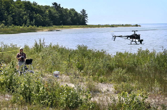
Using Unmanned Aircraft to Help Map Threatened Plant Species
Geography researchers at Central Michigan University have tested out the usability of UAVs in mapping out threatened plant species.

No Drones Zones: Map and GIS Data
Unmanned aircraft, known more commonly as drones, have a blanket ban by the Federal Aviation Authority in the United States over military ...