
open source GIS

Map Bookmarks: QGIS Python Programming CookBook
Learn how to create and navigate to map bookmarks using python in QGIS as part of this preview chapter, Creating Dynamic Maps from QGIS Python Programming CookBook.

Symbolizing Vector and Raster Layers: QGIS Python Programming CookBook
Learn how to symbolize vector and raster layers in QGIS using programming from this section of the preview chapter, Creating Dynamic Maps from QGIS Python Programming CookBook.
Accessing the Map Canvas, Changing Map Units, and Iterating over Layers
Learn how how to control an object through the Map Canvas, change map units, and how to loop through map layers in QGIS using Python. From: Creating Dynamic Maps from QGIS Python Programming CookBook takes a look at

Free Preview of Mastering QGIS
Mastering QGIS is designed to bring users who want to go beyond the basics of QGIS to an advanced level ...

Working with Coordinate Reference Systems: Mastering QGIS
This section of the free chapter preview of Mastering QGIS looks at working with coordinate systems in QGIS. Mastering QGIS is designed to bring users who want ...

Styling Vector and Raster Data: Mastering QGIS
This section of the free chapter preview of Mastering QGIS looks at styling vector and raster GIS data in QGIS. Mastering QGIS is designed to bring ...

Adding Functionality with Plugins: Mastering QGIS
This section of the free chapter preview of Mastering QGIS looks at using plugins to extend the functionality of QGIS. Mastering QGIS is designed to bring ...

Composing Maps: Mastering QGIS
This section of the free chapter preview of Mastering QGIS looks at making maps in QGIS. Mastering QGIS is designed to bring users who want to go ...

Working with Tables: Mastering QGIS
This section of the free chapter preview of Mastering QGIS looks at working with tables in QGIS. Mastering QGIS is designed to bring users who want ...

Loading Data: Mastering QGIS
This section of the free chapter preview of Mastering QGIS covers loading different data types into QGIS desktop. Mastering QGIS is designed to bring users who want ...
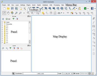
Tour of QGIS: Mastering QGIS
This section of the free chapter preview of Mastering QGIS covers the graphical user interface components of both QGIS Desktop and QGIS Browser. Mastering QGIS is ...
QGIS Download and Installation: Mastering QGIS
This section of the free chapter preview of Mastering QGIS covers downloading and installing QGIS. Mastering QGIS is designed to bring users ...

Mapping Almost 250 Years of Buildings in Manhattan
Morphocode‘s Urban Layers allows users to drill down and view the history of Manhattan’s buildings by mapping out over 45,000 ...

Searchable Database of Coordinate Systems
If you need a consolidated place to search for coordinate systems, EPSG.io is a place to start.

OWGIS – Open Source GIS Web Application
Standing for Open WebGIS, the developers of OWGIS describe it as an “OpenSource Java Servlets web application that creates WebGIS sites ...

Travel through Time with New York City’s Maps
The New York City Public Library introduces an online map warping tool, offering access to over 10,000 historical maps of the city.

Anita Graser | Profiles from the Geospatial Community
Anita Graser, a prominent figure in open source GIS, authored "Learning QGIS 2.0". She shares insights on her GIS journey and the future trends in open source GIS.
QGIS 2.0 Released
A new release of QGIS, the popular open source GIS software has officially been released. Each version receives a name ...

Making Maps with D3
D3 is a JavaScript data visualization library using HTML, SVG and CSS. D3 stands for Data Driven Documents and was developed by Mike Bostock, ...

QGIS: Introducing the Quantum GIS Ecosystem
Anita Graser provides an introduction to the desktop, web, and mobile capabilities of the open source GIS software, QGIS in this guest article.
Getting Started With QGIS: Open Source GIS
Quantum GIS is an open source GIS desktop software more popularly known as QGIS. QGIS 1.0 was first released in ...

WorldMap: An Open Source Software Platform
Harvard’s Center for Geographic Analysis recently released WorldMap, an open source mapping application designed to make it easier for researchers to upload ...
How to Go from GIS Novice to Pro without Spending a Dime
I have only taken one formal course in GIS; however, I consider myself a confident practitioner of the software and ...

What is Open GIS?
Open GIS is the full integration of geospatial data into mainstream information technology.