
Articles

Opinion piece: How Micro-Location, Geofencing and Indoor Location Are Driving The Retail Revolution
Indoor Location has become the holy grail of location based-marketing, bringing consumers from their home to the closest shopping mall ...

ArcGIS Explorer vs. ArcGIS Online: A Side by Side Comparison
Two of Esri’s principal GIS viewing products, ArcGIS Explorer Desktop and ArcGIS Online, offer a variety of tools for both business and personal use. Tracey Dash takes a look at some of the key differences between the two programs.

Tips for Using the Field Calculator in ArcGIS
The field calculator in ArcGIS is a great tool for manipulating the contents of both numerical and string fields in ArcMap. Listed here are some tips and resources for using the field calculator in ArcGIS with Python and VBScript.

Mapping 92 Years of Bigfoot Sightings
Joshua Stevens has mapped out the location of Big Foot sightings in the United States.

Satellite Mapping of the Great Barrier Reef
For the first time, a complete bathymetry high resolution (30 meters) bathymetry map is available of the Great Barrier Reef. The map was produced by remote sensing company, EOMAP using satellite data and imagery.

Mapping All the Swimming Pools in Los Angeles
Los Angeles is known for its nearly constant sunshine and warm climate so it’s no surprise that the region contains ...

Six Interesting Maps of 2013 (and One Graphic)
Everyone loves a great map. Maps engage readers and help them discover something they wouldn’t otherwise have learned about the ...

New Detailed Maps Show Changes in Earth’s Forests
Deforestation, the clearing and removal of the Earth’s forests, has been one of the major environmental threats to the globe ...

Visualizing American Migration Without a Map
As a cartographer, the display of spatial information is of great interest to me. I’ve been particularly intrigued by analysts ...

Anita Graser | Profiles from the Geospatial Community
Anita Graser, a prominent figure in open source GIS, authored "Learning QGIS 2.0". She shares insights on her GIS journey and the future trends in open source GIS.
Free and Open Access to Sentinel Satellite Data
The European Space Agency (ESA) has announced that free and open access to Sentinel satellite data will become available during ...
Typhoon Haiyan (Yolanda): The Mapping Response from the Tech Community
Typhoon Haiyan (locally referred to as ‘Yolanda’[1]) made landfall in the Philippines on Friday November 8th 2013. Officially, 1839 people ...

National Safe Routes to School Program Calls for GIS Initiatives
The National Safe Routes to School program (SRTS) was primarily created to promote safety for children who walk and bike ...
Managing Africa’s Water from Space
Water is a vital component for human life, and one of the major problems facing the continent of Africa is ...

ZIP Code Data is “Commercially Sensitive” Per the US Postal Service
Robb Shecter of the Weblaws.org site wanted to map out restaurant health inspections in Multnomah County, Oregon as part of his ...

Automating Extracting GIS Data from Scanned Maps
The New York Public Library Labs (NYPL Labs) has posted on Github the code to its open source map-vectorizer project. NYPL ...

National Digital Stewardship Alliance Releases Report: “Issues in the Appraisal and Selection of Geospatial Data”
The National Digital Stewardship Alliance (NDSA) has published a report titled "Issues in the Appraisal and Selection of Geospatial Data" in PDF format.

Find Old GIS Software Programs
Take a walk down memory lane and find old GIS software programs hosted by the Internet Archive.
University of Florida Website Offers Free GIS Data
Tracy Dash, a GIS specialist with a surveying company near Jacksonville, Florida, introduces the FGDL Metadata Explorer which provides access to free GIS data. Dash holds an undergraduate degree is in Sustainable Design, and a graduate certificate in GIS.

GOCE Gravity Mapping Mission Has Ended
GOCE, which stands The Gravity field and steady-state Ocean Circulation Explorer was launched with the purpose of mapping the Earth's gravity field at a high level of detail.

How to Check Your GIS Data
GIS manager Noam Rozenfeld discusses the significance of error-checking in GIS data and evaluates Esri's ArcGIS Data Reviewer.
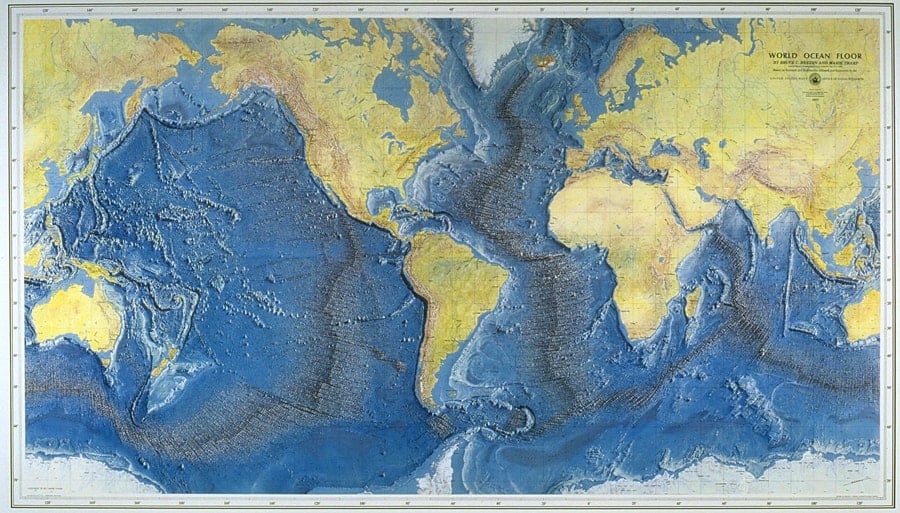
Marie Tharp and Mapping the Ocean Floor
As an oceanographic cartographer, Marie Tharp is credited with scientifically mapping the ocean floor in partnership with her colleague Bruce Heezen. Tharp and Heezen’s work was revolutionary, in that led to many discoveries and the theories of continental drift of plate tectonics. Tharp was a pioneer in science both as a woman and for her mapmaking.
New Portal for Free SPOT Vegetation Satellite Data
There is a new distribution portal for accessing SPOT vegetation data. The Belgium site, VITO (Flemish Institute for Technological Research), ...
Using Remote Sensing to Combat Poverty
Remote sensing, the practice of gathering information about objects without being physically near them, has had many practical uses for ...

Opinion Piece: The Future of GIS
Noam Rozenfeld, a GIS project manager at the Survey of Israel, discusses the future trends of GIS, highlighting emerging geospatial technologies that will become common tools in the field.