
Geo Contributor

What is is the Difference Between Web GIS and Internet GIS?
Majid Hojaty, a MSc student of GIS and Remote Sensing with Tehran University, Iran, discusses the differences between web GIS and Internet GIS.

The Usability of a Web Mapping Application with a Million Rows of Data
Manuel Timita write about Illustreets, a web mapping application built with Open Source software, open data, and emerging GIS technologies (i.e. CartoDB).

Opinion piece: How Micro-Location, Geofencing and Indoor Location Are Driving The Retail Revolution
Indoor Location has become the holy grail of location based-marketing, bringing consumers from their home to the closest shopping mall ...
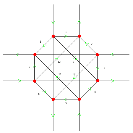
Turn Restrictions Simplified
Tim Hirrel takes a look at a new method for implementing turn restrictions in GIS street data.

GIS and Natural Resource Management
Peter Rodericks Oisebe, a Natural Resource Management Consultant in Kenya writes about the applications of GIS in mapping and managing natural areas.

Geospatial Technologies in Precision Agriculture
Discoveries in the field of science and technology have enabled farmers to effectively use their input to maximize their yield.

Data Capture in GIS
This article provides a brief overview of the GIS data collection process along with examples of methodologies for GIS data ...

How Can Looking at Hurricane Tracks Help to Understand Them?
Robert Lang's GIS tutorial employs public hurricane mapping sites to comprehend hurricane tracks, with exploratory questions incorporated within the tutorial steps.

Inequality Tutorial Using Instant Atlas
This tutorial looks at how the Instant Atlas map viewer allows the user to compare different areas in the UK.

QGIS: Introducing the Quantum GIS Ecosystem
Anita Graser provides an introduction to the desktop, web, and mobile capabilities of the open source GIS software, QGIS in this guest article.

Analysis Finds Three Times More Farmers’ Markets in Areas with the Lowest Obesity Rates
An independent analysis conducted by mapping analytics firm PetersonGIS shows that locations with the highest obesity rates contain the fewest farmers’ markets.

Explaining Socium, a Cloud Based GIS Data Validation Service
Abbie Beckford, Customer Relations and Marketing Manager at Socium, shares insight about the new launch and what the benefits of ...

Fusing Fine Art with Cartography
David McCarter's cartography infuses fine art with map making to create colorful maps.
Creating Maps for Wikipedia and Printed Materials with ShareMap.org
By: Jakub Kaniewski The availability of simple online mapping tools (such as what Google Maps offers) allows those with limited ...
Using Location-Based Services to Build a Social Network
Avoiding the Google-Apple-Facebook Trap: How Enterprises Can Provide Their Own Mobile Solutions – a whitepaper by Dr. Alexander Koeppen and Michael ...

Seeing Philadelphia’s Past in Augmented Reality
Guest article by Deborah Boyer and Andrew Thompson. For over 140 years, the City of Philadelphia has been taking pictures ...
Every Tree Counts: Using PhillyTreeMap for Collaborative Urban Forestry
Philadelphia, like many American cities, has a wealth of urban trees. Collectively known as the “urban forest,” these are the ...
Geomarketing for the Retail Industry
This guest submission by Michael Fabing from the company Mapfusion, a web-software company specialized in GIS mapping and geomarketing. Geomarketing and Geocoding ...

Making Maps in the Dark
Bluesky International, an aerial survey company, utilizes advanced thermal survey equipment to accurately measure heat loss from buildings and structures across the UK at night.
GIS Use By Power Distribution Companies
Jayant Sinha writes about the application of GIS and geospatial technologies in the power distribution sector. Sinha has over 24 ...

Sidewalk Inventory Study: Improving Safety, Walkability, and Development Issues for the City of Rancho Cucamonga
A sidewalk inventory program implemented for the City of Rancho Cucamonga, CA, is not only resolving safety concerns but will ...
Why GIS Doesn’t Replace the Need for Surveyors
With all the readily available aerial and satellite imagery, it is a legitimate questions to ask if GIS can be ...
Trimble GPS Handhelds Support Green Initiatives for the City of Shanghai
City of Shanghai implements environmentally conscious initiatives using Trimble GPS technology to improve the quality of life for city residents. ...

BantamGIS
Michael Chamberlain discusses the motivation and process behind the creation of his website, BantamGIS.com.
Mapping Citizen Engagement through GIS
Guest article by Timothy W. Carl Nowadays mapping tools are commonplace, especially on the internet, and we can see anything ...
Urban Disaster Prevention Spatial System
Guest article from SuperGeo. SCENARIO On September 21st, 1999, a 7.3 strong magnitude earthquake rocked Taiwan. It caused thousands of ...