
GIS Data
This category contains introductory text about GIS data such as types of error in GIS datasets, types of GIS data (raster and vector), and metadata.

Microsoft Releases Canada Building Footprint Database to OpenStreetMap
Microsoft recently announced that it had released 12 million building footprints in Canada to the OpenStreetMap community.

Fire Danger Reanalysis Dataset
Researchers have made 38-years worth of global fire danger reanalysis available as an open dataset.

Topography of Australia’s Intertidal Zone Available as Open Data
The National Intertidal Digital Elevation Model (NIDEM) is the first 3D model of Australia's intertidal zone. It is available for downloading as an open source dataset from Australia's National Map portal.

What are the Benefits of Landsat’s Current Free and Open Policy?
A group of researchers from different universities and government groups have published a study of how Landsat's free and open data policy has benefitted users of the programs satellite imagery products.

USGS 3DEP Lidar Point Cloud Repository Available as an Amazon Public Dataset
Representing trillions of LiDAR points, USGS 3DEP Lidar Point data is now available as an Amazon Public Dataset.

Updated World Magnetic Model To Be Released
An acceleration in the Earth's magnetic field has triggered an early update to the World Magnetic Model.
“Adopt A Pixel” to Help Landsat Science
Adopt A Pixel program has existed for quite some time - from 2013 - in the form of a web service which allowed users to upload geospatially tagged landscape images to complement the remote sensing collections.

Mapping Where Norway is Moving
Norway is using Copernicus Sentinel-1 data to detect ground movement across the country.
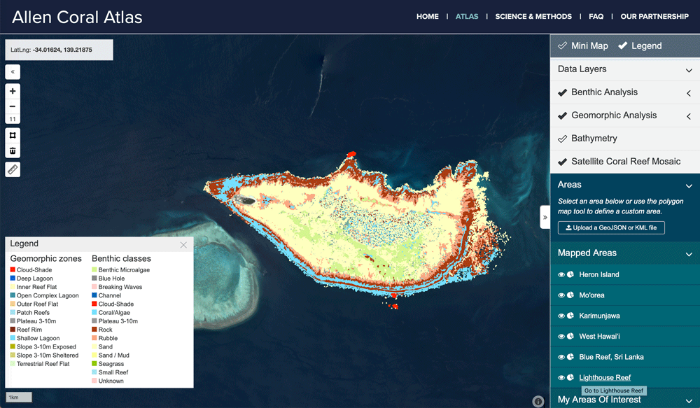
Mapping Coral Reefs
Scientists have been developing better ways to fuse data from different satellite systems and data capture, while also developing classification algorithms to better map coral reefs.

PACE: NASA’s Earth Observation Satellite to Launch in 2022
NASA’s PACE (Plankton, Aerosol, Cloud, Ocean Ecosystem) is a planned earth observation satellite with an anticipated launch in 2022.


Using Machine Learning and Satellite Imagery for Street Address Generation
Facebook and MIT Labs researchers have developed a method employing machine learning and satellite images to create street addresses in regions lacking unique building addresses.

Awesome Public Datasets
If you're looking for sources of public data tucked into web sites, then check out Awesome Public Datasets, Free GIS Datasets, and Open Data Inception's map of open data portals.

NOAA Offers Post-Hurricane Aerial Imagery
NOAA has been capturing aerial imagery showing the post-Hurricane Michael destruction across the Florida Panhandle.

Layers and the Future of Data and Analytics in Business
As location technology becomes more commonplace, democratizing spatial data, and making it accessible to every business profession will be critical to future business planning.

Mapping Tree Species in the Amazon Using Satellite Imagery and Machine Learning
Researchers have modeled tree species distribution in Peruvian lowland Amazonia using satellite imagery and machine learning techniques.

Detecting Storm Intensity from Satellite Imagery Using Machine Learning
The Deep Learning-based Hurricane Intensity Estimator is an experimental portal that uses machine learning techniques to analyze spatial patterns in infrared satellite imagery in order to predict tropical cyclone intensity.

High Resolution Elevation Data for Antarctica
Recently two high resolution digital elevation models of Antarctica were released for the public to free use.

Google Launches ‘Dataset Search’
Google latest Beta launch, Dataset Search, is designed to make it easier for users to search for and find datasets found across the web.

What Imagery Source is Best for Your Business?
Erin Jepperson, Technical Sales Engineer at Nearmap, outlines how to weigh the pros and cons of aerial imagery and drone imagery.

PaleoDEMs: Map the Earth’s Changing Topography Over the last 540 Million Years
Users can download paleogeographic datasets reconstructing paleotopography and paleobathymetry dating back to 540 millions years ago

Accessing Real-time Satellite Imagery and Data
NASA's LANCE and EarthNow, a space imaging business, are paving the path to real-time and near real-time satellite data.

Ocean and Land Observation Data From Sentinel-3B
The main mission of the recently launched Sentinel-3B is to provide quality ocean and land monitoring. As part of the Copernicus program, GIS data and imagery will be made freely available.

Creating Ground-level Views from Satellite Imagery
Recreating a ground-level image and perspective using satellite imagery has only recently been developed.

A New Global Peatland Map Expected for 2020
A new global high-resolution peatland map is expected for 2020.
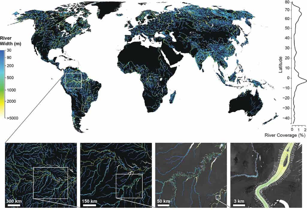
Global Dataset of River Widths Developed from Landsat Imagery
Researchers used a combination of satellite imagery and field measurements coupled with statistical modeling to calculate worldwide river and stream surface measurements which is now available as a GIS dataset.