
GIS Data
This category contains introductory text about GIS data such as types of error in GIS datasets, types of GIS data (raster and vector), and metadata.
125 Million Building Footprints in the US Now Available as Open GIS Data
Microsoft has made 124,885,597 footprints from all 50 U.S. states available as open data.

Improving Geospatial Data Search
Open standards and protocols have facilitated data sharing and application for spatial information on the web such as using Web Map Service (WMS).

Swarm Satellites Bring New Findings About Ocean Magnetism
In 2013 the European Space Agency (ESA) launched a trio of satellites called “Swarm”, which are specialized in capturing Earth’s magnetic activity including ocean current magnetism
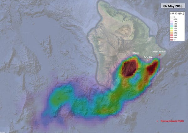
Sentinel-5P Tracking Emissions from Hawaii’s Kīlauea Volcano
Researchers are using data from the Sentinel-5P satellite to map out sulphur dioxide emissions from Hawaii's Kīlauea volcano.

Using Drones and Remote Sensing for Mapping and Counting Animals
Remote sensing data from satellite and UAV imagery has been used by researchers in the mapping and observation of wildlife, in particular counting the number of animals in remote locations.

Black Marble: Nighttime Lights Data from NASA
NASA's Black Marble provides a suite of nighttime geospatial data acquired from Suomi satellite's Visible Infrared Imaging Radiometer Suite instrument.

What are Weird Polygons?
The straightforward definition of a weird polygon is a GIS data feature that is missing nodes.
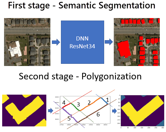
Using Machine Learning to Speed Up Electrical Grid Mapping
Development Seed, working for the World Bank Group, created a methodology for integrating machine learning with manual mapping in order to speed up the mapping of high-voltage (HV) grids in developing countries.

Where to Find GIS Data for Historical Country Boundaries
Finding historical GIS data can be hard to find. Listed here are available sites that offer historical country data in GIS file formats.

Over 2000 Sentinel-1 Satellite Images Were Used to Create a Map of Land Deformation in the United Kingdom
A new map of the United Kingdom map tracks areas of land subsidence and uplift based on processed data from Sentinel-1's Synthetic Aperture Radar (SAR).

Mapping Minerals with Satellite Imagery
Mapping minerals with remote sensing was one of the main motivating reasons for creating the earliest multispectral satellite systems.

Tool from Sentinel Hub Lets You Create Time-lapse GIFs from Satellite Imagery
The EO Browser allows creating animated GIFs from satellite image time series. This tutorial demonstrates how to create your own time-lapse GIF.

The Use of Drones in Human and Physical Geography
With the widespread use of drones, methods are likely to be further refined to improve not only the use of UAVs in physical measurements in geography but even expanded to areas of the social sciences.

GIS, Data Preservation, and Gentrification
Olivia Harne discusses how smart planning that incorporates GIS needs to take into account the historic identity of gentrifying neighborhoods.

Rapid Ocean Floor Mapping
Rapid ocean floor mapping is considered one of humanity’s grand challenges. To highlight this challenge, Xprise recently announced the finalists for its grand challenges competition to rapidly map the ocean floors.

LiDAR: Light Detection And Ranging
LiDAR systems are used to collect high resolution topographic and bathymetric data.

Developing Damage Proxy Maps from Satellite Data
Satellite data is being used to create Damage Proxy Maps to assess changes in an area as the result of natural disasters like Hurricane Maria in Puerto Rico, and the wildfires that have hit Northern and Southern California.

Watch Landsat 8 Imagery Acquisition in Near Real-time
The FarEarth Global Observer offers visitors the opportunity to view near-live streams of Landsat 8 imagery being acquired in near real-time.

GIS File Formats
Listed here are some of the more common file formats along with associated file extension for GIS file types.
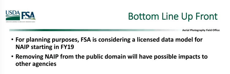
NAIP Aerial Imagery Might be Moved from the Public Domain to a Licensing Model
The Farm Service Agency (FSA) is considering moving its National Agriculture Imagery Program (NAIP) from a free aerial imagery service to a licensing model starting the 2019 fiscal year.

UAVs, GIS, and Ecology
With the relatively cheap price and increasing effectiveness of unmanned aerial vehicles (UAVs), often called drones, we are seeing much more accurate estimates and understanding of ecological change.

Monitoring Air Pollution with Sentinel-5P
Sentinel-5p will be one of the first satellites that provides high resolution pollution monitoring and will provide a large data capture that enables daily and even hourly monitoring.

The USGS Landsat Analysis Ready Data (ARD) Program
Landsat data, referenced with WGS84 and provided as GeoTIFF, can be accessed from EarthExplorer for the contiguous US, Alaska, and Hawaii.

Entire National Spatial Reference System (NSRS) to be Modernized in 2022
In 2022, the National Spatial Reference System (NSRS) is scheduled to be modernized, with new reference frames replacing the NAD 83 system and the North American Vertical Datum (NAVD) 88.

Mapping Global Forest Biomass
The European Space Agency is using satellite radar data collected from their satellites to measure how much wood is in the world’s forests globally.

Methods for Creating Cloud Free Satellite Imagery: Sentinel 2
Nearly 70% of the globe is covered by clouds at any given time. Several methods have been developed to remove cloud cover from satellite imagery.