
GIS Data
This category contains introductory text about GIS data such as types of error in GIS datasets, types of GIS data (raster and vector), and metadata.

Open Data Site Established for Hurricane Harvey
An open data site has been set up to house GIS data from authoritative sources relating to Hurricane Harvey.

How LiDAR is Being Used to Help With Natural Disaster Mapping and Management
Michael Shillenn, vice president and program manager with Quantum Spatial outlines three projects where LiDAR data from the USGS 3D Elevation Program (3DEP) has been used to assist in planning, disaster response and recovery, and emergency preparedness.
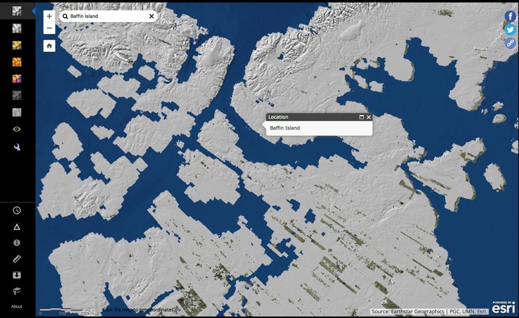
View Arctic Elevation Data with ArcDem Explorer
ArcticDEM is a project that is working to produce digital elevation models of the Arctic in order to see how topographical changes are occurring over time, such as the rate at which glaciers are receding.

Digitizing Errors in GIS
Digitizing in GIS is the process of converting geographic data either from a hardcopy or a scanned image into vector GIS data by tracing the features. Explained in this article are the types of common digitizing errors found when creating geographic data within GIS.

Jason-2 Satellite to Help Improve Maps of Sea Floor
Jason-2 will be collecting data about the sea floor every 5 miles, which will be used to create a high-definition estimate of the average surface height of the ocean in various places around the globe.

Automated Generalization Sped Up Cartographic Output by 40% for This German Mapping Agency
Working with 1Spatial, AdV’s ATKIS-Gen Project Group's cartographic output is 40% faster with automated generalization.

Mapping Rainforest Chemistry
Researchers mapped 23 chemicals that are released by the rainforests in Peru with laser-guided imaging spectroscopy.

ESA’s Swarm Satellites Reveal Detailed Variations in the Earth’s Magnetic Field
Three years of data collection the European Space Agency's (ESA) Swarm satellites has resulted in the highest resolution map of Earth’s lithospheric magnetic field.

How 1Spatial is Helping the Arizona Department of Transportation Automate Validation of State-Wide Road Network
Sheila Steffenson discusses how the Arizona Department of Transport will be able to validate and integrate its own road network information with regular updates from multiple contributing government bodies within the state using 1Spatial technology.

3.1-Trillion Pixel Landsat 8 Mosaic of the World
Descartes Labs has compiled some of the massive amount of data sent back from the satellites orbiting Earth into a 3.1-trillion pixel composite image of Earth’s surface.
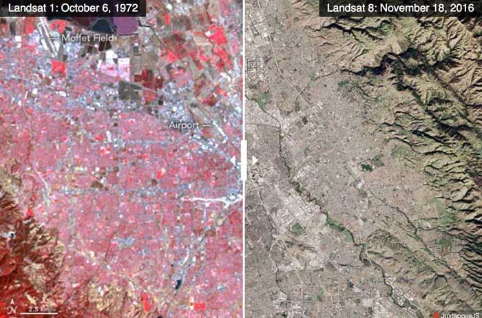
Advances in Landsat Sensors
Since those first images in 1972, multiple Landsat satellites have been launched with the ability to take increasingly detailed pictures of our world.

Open Data Program Launched by DigitalGlobe
The Open Data program offers high-resolution satellite imagery and crowdsourced GIS layers for large-scale natural disasters.

How Robots Can Help Improve GIS Data
Robotic platforms are actively used to collect spatial data, including GPS data, to help map floor plans and wider areas.

Mapping Billions of Data Points in Milliseconds
With its GPU power, MapD can process and map billions of data points in milliseconds.

Learn How to Access and Use Sentinel-3 Data
Learn how to download and use earth observation data from ESA's Sentinel-3 satellite.

Find Users of Open GIS Data from Around the World Thanks to the Center for Open Data Enterprise
The Center for Open Data Enterprise is working to improve the quality of open access data worldwide, including GIS data sources.

GIS and Semantics: Enabling the Discoverability of Data
Much like the semantic web, methods exist in GIS to streamline the search of diverse geospatial data through certain protocols and standards.

Landsat 9 Will Launch in 2020
The Landsat series of satellites has been imaging the Earth’s surface for nearly 50 years, providing vital imagery for a range of purposes from the natural sciences to civil administration and conflict monitoring. NASA and the USGS recently announced that the next iteration of the program, Landsat 9, is due to launch in 2020.

GIS and Social Activism
Groups promoting various causes are implementing geospatial approaches and GIS related technologies.

Making 3D Models with Photogrammetry
With the prevalence of smartphones and drones, photogrammetry is now widely present as an effective and cost-efficient method to easily recreate 3D models of large areas and specific objects or buildings.

Mini Satellite Constellation to Explore the Outer Reaches of Our Atmosphere
An international scientific project is conducting an unprecedented study of the atmosphere’s outermost layer. Fifty tiny satellites will measure the attributes of the thermosphere, a poorly understood but vitally important region.

Integrating Spatiotemporal Data with Terra Populous
Terra Populus is a project designed to combine data sets and geographic information to facilitate finding and extracting data for research.

A Look at KML, an Open Standard to Represent and Visualize Spatial Information
Yang Zhang, associate professor, and Matthew W. McBroom, professor, with Stephen F. Austin State University, provide a brief systematic introduction to KML (Keyhole Markup Language) files.

View Landsat 8 Imagery With This Free Tool
Users can search, view, and access Landsat 8 imagery with this free online web viewer developed by EOS Data Analytics.

Use of Earth Observation Data for Oil and Gas
Andrew Cutts, owner of ACGeospatial, discusses the role of GIS and earth observation data in the oil and gas industry in this guest article.

FAO Uses GIS to Protect Agricultural Economy of Vulnerable Countries
Lucia Moro, with the Food and Agriculture Organization (FAO) Geospatial of the United Nations, discusses the agency's work on the development of a global land cover database to support agricultural policy makers and rural land use planners efforts to reduce poverty.