
GIS Software
Information about GIS software and applications including both commercial and open source GIS applications. This category covers desktop GIS (Esri’s ArcGIS suite, MapInfo, QGIS, and GRASS) as well as web mapping, GIS apps, mobile GIS, and component GIS.
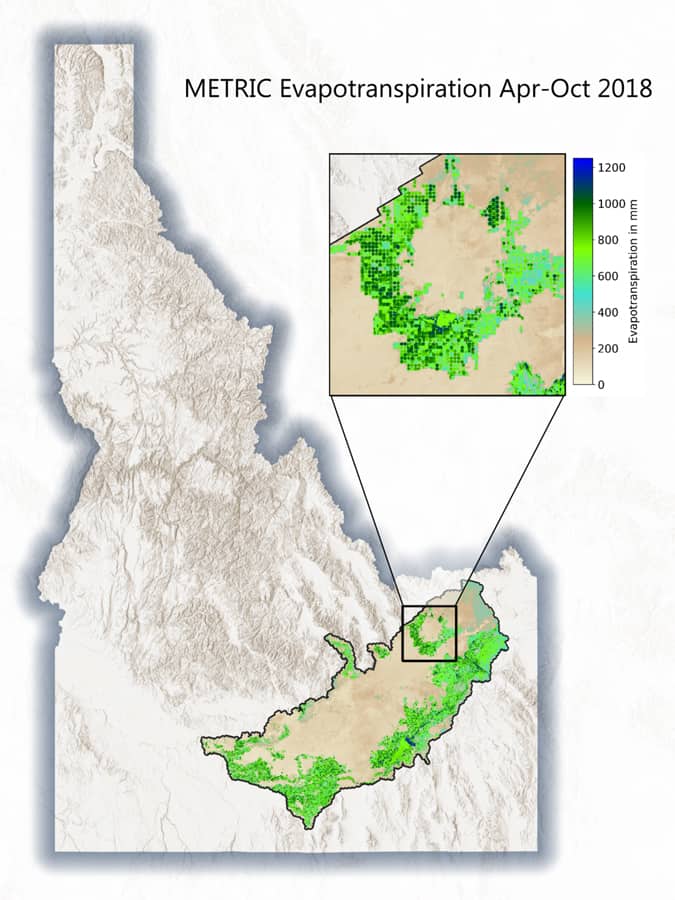
Geospatial Tools for Agricultural Water Management
The use of geospatial technologies can help mitigate inefficient use of water and help improve how this precious resource is used in crop production.

How to Create Firefly Cartography with QGIS
Firefly cartography is a cartographic style used to create maps that glow. Learn how to make a firefly map using QGIS.

Making Joy Plots with GIS
Joy plots is a cartographically creative way to show topography on a map. Learn how to create joy plots using GIS.
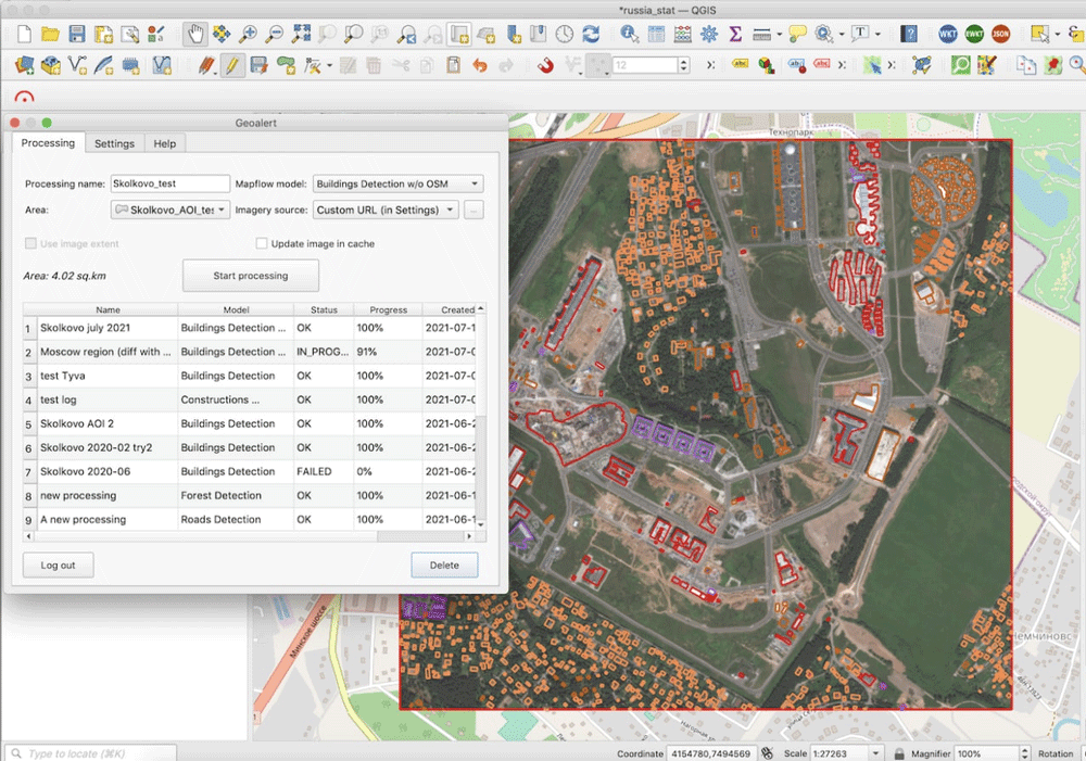
Run AI-Mapping in QGIS over high-resolution satellite imagery
Mapflow is a QGIS plugin that lets users extract real-world objects from satellite imagery.

6 Open Source Powered Projects to Enrich Your GIS Programming Skills
This article presents six projects with suggested tools, prerequisites and learning resources that would help you to improve your geospatial programming skills.
GDAL: Geospatial Data Abstraction Library
The Geospatial Data Abstraction Library (GDAL) is a set of software tools used by GIS platforms such as ArcGIS, QGIS, and GRASS GIS.

How to Use ArcGIS Pro to Estimate Areas Prone to Malaria
This tutorial uses Spatial Data Science and Remote Sensing techniques (ArcGIS Pro) to estimate areas that are prone to malaria using ArcGIS Pro.
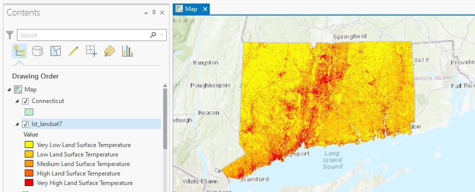
How to Use ArcGIS Pro to Calculate Land Surface Temperature (LST) from Landsat Imagery
This ArcGIS Pro tutorial utilizes spatial data science and remote sensing techniques to calculate land surface temperatures using Landsat imagery.
A Look at Google Earth Engine
In a MapScaping podcast episode, Quisheng Wu discusses Google Earth Engine how it allows users to share and upload their own geospatial analyses.

How to Use ArcGIS Pro to Assess Landslide Susceptibility
This tutorial explains how landslide susceptibility can be assessed using ArcGIS Pro.

Using ArcGIS Online to Manage Content
With the Item Report Dashboard from GEOACE, you can use out-of-the-box tools in ArcGIS Online to manage content within an organization.

Openlayers: Geospatial JavaScript Library
One of the most under-utilized programming languages in geospatial analysis and processing is JavaScript.

Using Map Projections with Maptitude
Stewart Berry discusses how Maptitude works with different map projections.

WebGIS Section 2: Overview of Tools and Technologies For WebGIS
This article introduces you to some of the open-source tools used in WebGIS.

Why GRASS Delivers Powerful GIS Capabilities
A recent MapScaping podcast with Markus Neteler, chairman on the GRASS GIS Project Steering Committee, makes it is clear that GRASS will continue to be a powerful GIS open source effort for years to come.

Series: WebGIS Using Open Source Tools
Emmanuel Jolaiya's series on WebGIS using open source geospatial tools and technologies.

QGIS Style Sharing Repository
A new tool has been deployed that lets QGIS users share style files.

Esri Debuts New GIS Tools and Apps at the 2020 Annual User Conference
The first two plenary sessions contained a lot of demonstrations by Esri staff featuring the new GIS tools and applications launching this year.

QGIS and Free Mobile Applications
The capabilities of QGIS can be extended with plugins and mobile GIS apps.

Python and Geospatial Analysis
Two recent podcasts from MapScaping take a look at the use of Python in geospatial analysis.

Building a Model with ArcGIS ModelBuilder Saves Time
Emmanuel Jolaiya shows users how to use ArcGIS ModelBuilder to develop a model for for analyzing and manipulating GIS Data.

An Introduction to ArcGIS ModelBuilder
In this overview, Emmanuel Jolaiya introduces readers to ModelBuilder in ArcGIS which can be used to build models for analyzing and manipulating GIS Data.

EarthPy: Python Package for Plotting and Working with Spatial Data
A Python language spatial package, called EarthPy, has been released for free download for working with GIS data.

24 Days of QGIS Tips
Using the #24daysofqgis hashtag, North Road, a geospatial company based out of Australia, will be tweeting out a QGIS tip or trick for 24 days starting on December 1.

How to Use GIS to Make a Lego Map
Depending on the GIS software you want to use, there are a few different ways to create a Lego-style map.

Portable GIS
Portable GIS is a collection of open source GIS software applications and tools that can be run from a portable drive.