
Human Geography
Human geography is a branch of geography that focuses on the study of the human population and their cultural, economic, and social interactions with the environment. It examines the distribution of human populations across the globe, the impact of human activity on the natural environment, and the ways in which people use and manage natural resources.
Learn about the different areas of human geography including economic geography, population geography, cultural geography, and more.

What is the Nationality of a Baby Born on an Airplane?
It is a question that confounds the most geographically and legally astute: what is the nationality of a baby born on an airplane?
What is Contemporary Geography?
The study of Geography has always been evolving and at critical times there have always been question such as “why ...

Reducing Climate Change Could Be More Difficult in the Future
A recent study has declared that limiting climate change in the future could be more difficult due to shifting conditions ...

Geographic Spread of the Indo-European Language Family
A recent study by the Australian Centre for Ancient DNA and Harvard Medical School looked at the initial dissemination of Indo-European languages.

The World’s Largest Mass Migration
Surrounding the Chinese New Year is a forty-day travel period known as "Chunyun," meaning “Spring Festival Transport”. Each year, Chinese officials calculate that well over 3 billion passenger trips occur during this period and overwhelms the Chinese transportation system.

Economic Geography of Your Valentine’s Day Chocolate
Americans spent $700 million on chocolate treats for Valentine’s Day in 2014.

Conflict over Gibraltar: Who has control?
Gibraltar is a 6.5 square kilometer territory located south of the Spanish border, along the Strait of Gibraltar. The small ...

Why Development Aid Projects Must First Factor Local Culture
Why do some multi-million dollar aid projects fail? The aid itself is not generally the problem, but the lack of local, geographic specific cultural analysis in planning and implementation is most often to blame.
How Rapid Urbanization Threatens Human Populations: Three Effects of a Moving World
The dramatic shift of the earth’s human population to cities is not only straining urban infrastructures, but also the human population itself. Three significant human threats resulting from rapid urbanization in developing countries are increased intense agriculture from the commoditization of food, rising diabetes and heart disease rates, and brain waste of our global youth.
Bert Monroy – An Artist at the Intersection of Geography and Art
Kristina Jacobs interviews Bert Monroy about his geography themed art.

Tourism in North Korea
More and more people are flocking to the tightly controlled state for a peek into one of the most mysterious nations on Earth.
Megacity
A megacity in geography is an urban area that contains more than 10 million residents.

Why is the Population of Japan Almost Double That of France?
Different countries around the world vary in cultures, populations and traditions, which helps make up the wonderfully diverse world we ...

What are Ley Lines?
The theory of geography that surrounds the existence of ley lines was created in 1921 by a man named Alfred Watkins.

Who Owns the Oceans?
This article explores some of the international convention on jurisdiction over oceans.

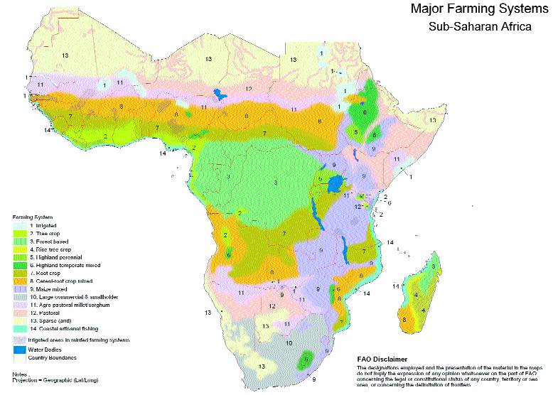
How the Ebola Outbreak has Highlighted Ignorance of Africa’s Geography
Despite the Ebola outbreak currently only affecting three countries that together make up less than 2% of the total area of Africa, the perception among some is that the entire continent of Africa is currently at risk.

Ocean Garbage Patches
Ocean garbage patches are concentrations of marine debris located in the North Pacific Ocean. These garbage patches are comprised of ...

Geocentric Direction Systems
A geocentric direction system is a topography-dependent orientation system.

What is a Geoglyph?
A geoglyph is a work of art which is created by arranging or moving objects within a landscape.

What Does the Acronym BRICS Stand For?
The term “BRICs” is an acronym developed from the names of countries that are in a similar stage of newly advanced economic ...

Using Social Media to Track Global Eating Habits
According to researchers, social media can be used to track and understand eating habits from around the world. These researchers ...

Geography of Car Thefts in the United States
The National Insurance Crime Bureau (NICB) each year takes a look at the national picture in terms of car thefts.

Who Did the Napa Earthquake Wake Up?
Jawbone aggregated data from thousands of UP activity trackers to see what percentage of people in the Bay Area were woken up by the Napa earthquake.

Geography of Languages
Information about which country has the most spoken languages, which country has the most official languages, and which language is spoken in the most countries.

Hot Cities Getting Hotter in the US
Climate Central has published a new report that took at look at the increases in temperature in sixty of the largest U.S. cities.

Urban Heat Islands
Urban heat islands are places in the world that have higher temperatures than the locations around them. These urban heat ...