
Human Geography
Human geography is a branch of geography that focuses on the study of the human population and their cultural, economic, and social interactions with the environment. It examines the distribution of human populations across the globe, the impact of human activity on the natural environment, and the ways in which people use and manage natural resources.
Learn about the different areas of human geography including economic geography, population geography, cultural geography, and more.

Changes in Arctic Environments
Using remote sensing, a team of researchers is studying the fragile arctic environments of Northwest Siberia and how resource extraction and a warming climate affect vegetation, permafrost, and energy budgets.

Mapping Worldwide Population Growth
A map was recently created by a a researcher from the Centre for Advanced Spatial Analysis, University College London that tracks where and when population has grown in various places around the world.

The Flooding of Chennai: Urban India and Climate Change
In late November and early December, flooding plagued South India and particularly Chennai. AJ Rohn takes a look at the confluence of climate change and urban India.

Do Protected Areas Have an Effect on Malaria Prevalence?
Recently, a paper by researchers at Penn State was published in Applied Geography that looks for connections between protected areas in Africa and malaria.

African Hydropower News
The construction of hydroelectric dams in Sub-Saharan Africa provides the opportunity to bring more power to the region and prepare for rapidly growing populations and offers benefits to health, agriculture, and more
The Geography of Gerrymandering in the United States
Gerrymandering is the practice of drawing or re-drawing congressional boundaries to benefit a specific political candidate or party. The Washington Post recently took a look at how gerrymandering has affected politics in the United States.

The Geography of Genius
The Geography of Genus, by Eric Weiner, takes a look at where and how geniuses flourish in the world.
Providing Good Directions Depends on the Order of the Words
How you order words when giving directions affects how quickly recipients can successfully follow those directions.

Errors in the Fortune 1000 Lists
This article discusses some of the errors prevalent in the Fortune 1000 lists from which the "Geography of Fortune 1000" series is based on.

Climate Change and Development
Researchers with the London School of Economics and Political Science published a report as part of the Pathways to Resilience in Semi-Arid Economies project that looks into reconciling economic development and poverty alleviation with climate change.

When it Comes to Geography Introverts Prefer Mountains
Researchers wanted to find out if introverts prefer a certain type of topography.

Language Development and Geography
Researchers around the world are pooling their resources and knowledge to find out how climate affects language development.

Vegetation Helps to Lessen the Effects of Urban Heat Islands
The abundance, or lack, of vegetation in a city can have an effect on how much heat cities retain, known as the urban heat island effect.

Changes in Light from Space
Astronauts on the International Space Station have studied the light emissions coming from older lights and newer LED lights and have found that LED lights actually make light pollution worse.

Uber Residential Pick-Ups in New York City Reflect Demographic Realities
A report reveals that ridership rates for both Uber and cab companies in New York City are equally distributed geographically.
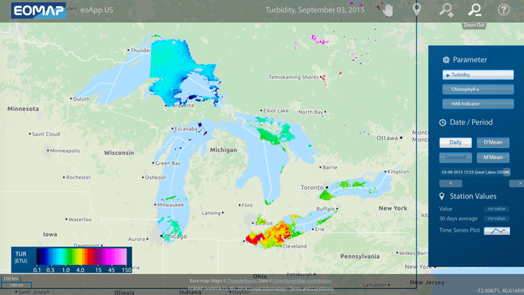
Mapping Algal Blooms in Lake Erie
EOMAP has released a mapping application designed to track algae blooms in Lake Erie.

Mapping the U.S. by Property Value and Land Area
How Urban Property Values are Adversely Affecting the U.S. Economy

Geography of Tweets
In an analysis of ‘big data’ from Twitter, people who lived in larger cities around the world were more likely to mention other large cities or international locations.

Tracking Populations Using Sewage
Scientists and researchers have recently begun tracking the populations of cities in the United States using the amount of sewage produced.

Mapping the Link Between Linguistic Diversity and Genes
Researchers are studying the link between language and genetics.

The Urban Heat Island Effect is Triggering Larger and More Spiders
Researchers in Australia have found that the urban heat island effect results in larger and more abundant spiders.


Map of Where the Population of Europe Is Growing and Where It’s Declining
An interactive map of Europe has been compiled with census data showing areas of the continent where the population is growing and declining.


EJSCREEN: Mapping the Connection Between the Environment and Demographics
EJSCREEN is a mapping app that intersects data sets from recent censuses and environmental maps to help users understand the relationship between the environment and demographics.

How to Build a Smart City in Twenty Steps
Lessons learned from urban planning projects around the world have been summarized into a short, 20-step do-it-yourself guide to building a Smart City.