
Human Geography
Human geography is a branch of geography that focuses on the study of the human population and their cultural, economic, and social interactions with the environment. It examines the distribution of human populations across the globe, the impact of human activity on the natural environment, and the ways in which people use and manage natural resources.
Learn about the different areas of human geography including economic geography, population geography, cultural geography, and more.

These US Towns Each Have Less Than 15 Residents
Here are a few smaller than small towns in the United States.

Using Green Space to Reduce Water Pollution
Researchers have used satellite data to analyze images for areas that should be protected as green spaces which in turn help protect Atlanta’s water supply.
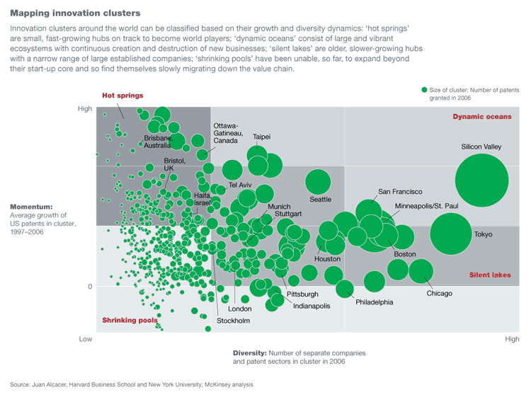
Geography of Innovation
By merging innovation theory with geography, researchers can explain why areas like Silicon Valley consistently lead in innovation.

Geography Mnemonic to Learn the Countries of Central America
Use a mnemonic to remember the countries of Central America in order from north to south: Belize, Guatemala, El Salvador, Honduras, Nicaragua, Costa Rica, and Panama.

GPS and a Grader Bring Back the Maree Man Geoglyph in Australia
The Marree Man is a geolyph located in the Australian Outback. A geolyph is an image or a picture that is a design in the earth, and it is usually made of natural materials.

Geography and Modern Slavery
Human geographers examine the interplay between economics, neoliberal capitalism, geography, and immigration to identify potential hotspots for human trafficking and slavery

How the Commutes of 130 Million Commuters Reveals Megaregions in the United States
A study using data from 130 million commuters has revealed commuter-driven megaregions in the United States.

Geography and Inequality
Simple examples of geographic social inequality can be found in major cities, where wealthier urban people generally have access to more housing, food shops, basic amenities, healthcare, and other infrastructure than the urban poor.
How Geography Influences Voting Behavior
Voter turnout in elections is heavily influenced by factors such as geographic proximity to polling places. Voter turnout is influenced by a variety of factors, including race, district size, district redrawing, and even weather.

Geography and Globalization
Globalization, significantly impacting society, has been a popular subject among human geographers.

Fantasy Geopolitics: The Gamification of Geography
Teacher Eric Nelson has create a fantasy geography called that combines his love of fantasy football with the study of current events.

A Conservation-Based Future in Colombia
By properly including indigenous and impoverished peoples in the new economy and securing communal land rights in the forests, as well as fostering soil recovery in areas of coca cultivation and managing resource extraction, Colombia can move into a more equitable and environmentally sustainable future.

Microbial Life in Fracking Fluids
The introduction of fracking fluids very drastically changes the underground microbial ecosystems which become dominated by bacteria that thrive in highly saline environments including those of a new genus named Frackibacter.

Storing Carbon in the Soil Through Regenerative Farming
In partnership with scientists and researchers, farmers are coming up with different ways to keep soil from degrading and releasing more CO2 into the air.

Geography of Fortune 1000 Companies in 2016
This article takes a look at the geographic distribution of Fortune 1000 companies within the United States for 2016.
Fortune 1000 Companies List for 2016
Table of Fortune 1000 companies which can be filtered to produce a list Fortune 1000 companies by state or by city.

Mapping the Movement of Migrants
A mapmaker named Max Galka created an interactive map that shows the migration of the world’s human population between 2011-2015 using UN Population Division data

Is Germany Landlocked?
The easiest way to tell if a country is landlocked is to take a look at a map of the country and the surrounding geography.

Swipe Through Satellite Data to Help Map Vulnerable Populations
MapSwipe and its team of digital volunteers utilize the abundance of smart phone technology to gather more information on natural disasters and the impact they have on people, cities, and countries around the world.

MapWatch: Tracking Political Cartography
Researchers from Northeastern University have created a database called MapWatch which shows how maps and borders change based on geography.

Climate Explorer Tool Offers Local Climate Change Maps and Models
Climate Explorer is tool created by a collaboration of many federal agencies that allows users to explore future changes in temperature, precipitation, and heating and cooling days.
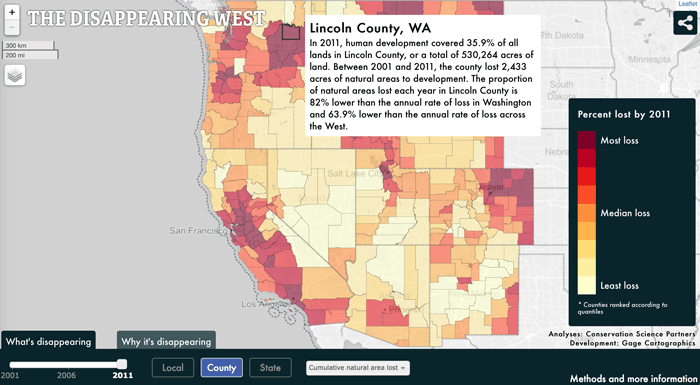
Map Documents America’s Vanishing West
A new mapping study is documenting the vanishing American West, beginning in 2001 and ending in 2011.

Mountaintop Removal Mining and Flash Floods in West Virginia
Mountaintop removal mining is when explosives are used to blast through the peak of a mountain and expose coal that is buried below. The practice has destructive consequences on the trees of the mountain, as well as the streams.

The Complex Geography of the Brexit Vote
A.J. Rohn takes a look at the geographical factors behind the recent vote in the United Kingdom in favor of leaving the European Union in its controversial Brexit referendum.