
Maps and Cartography
Maps and cartography are essential tools in geography that enable us to visualize and understand the Earth’s surface and its features.
Cartography is the art and science of creating maps, which involves the use of sophisticated technology and techniques to accurately represent the Earth’s physical and cultural features.
Maps provide a visual representation of the world, allowing us to identify patterns, explore spatial relationships, and navigate through unfamiliar terrain.

3 Ways to Send a Geo Season’s Greetings
Here are three ways you can pass along your end of the year cheer to geography enthusiasts no matter where they live.
7 Fun Stocking Stuffer Gifts for Geographers
Looking for items for your favorite geographer's Christmas stocking? The items on this list make perfect gifts for the geogeek in your life for gift exchanges with small budgets.

7 Nifty Gift Ideas for the GIS Person in Your Life
Whether you are looking for gifts for Christmas, Hanukah, Kwanzaa, Festivus, or just looking for a special gift for any time of the year, here are some gift ideas for a range of budgets. From silly to serious, find the perfect GIS gift idea on this list.

Geography of Conflict
Geography can show us how physical and social factors shape global conflict today and in the past.

3D Print Your Own Universe
Researchers have created a way for people to 3D print their own tiny universes using physics and modern technology.

Spot the International Space Station Using this Map
Even if you can’t reliably see the night sky, you can track the movement of the International Space Station with NASA’s Spot the Station interactive map.

Is this the Most Accurate Worldwide Map Projection?
This new map, called the AuthaGraph, may be the most accurate map projection created to date.

The Map Projection of the United Nations’ Flag
The United Nations flag with a white map on top of a light blue background, is universally recognized. Learn about the map projection used for the logo.

Cartography Without Knowledge: Mapping the Northwest Passage
The University of Southern Maine and the Arctic Council created a map exhibit highlighting the earliest attempts to discover the Northwest Passage.

Study Suggests that Men Aren’t Better at Reading Maps Than Women
A recent study tested if there are differences in spatial reasoning and perspectives between men and women.

Sunday Maptinee: Teaching Geography Through Humor
The Map Men have created a series of geography themed episodes highlighting some pretty cool information about the world around us.

Turning the Continents of the World into Animals
Kentaro Nagai continues the tradition of envisioning"maps as animals" and reworks the continents as part of his artistic piece from 2007 entitled, "The Twelve Animals."

Is Germany Landlocked?
The easiest way to tell if a country is landlocked is to take a look at a map of the country and the surrounding geography.

Sunday Maptinee: Grid Corrections
A Dutch artist travelled to locations around Oklahoma and Canada to take pictures of the turns and detours that make up grid corrections in the roads.

Cartography of Japan
A new book has surveyed maps created by cartographers in Japan spanning 500 years.
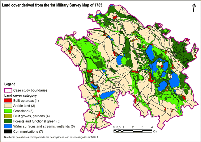
GIS and Modern Research from Historical Maps
While GIS offers a way to digitize detailed historical records and maps, it can also provide a new way to understand history and trends over time.

Sunday Maptinee: Imagining the World Anew
Looking at the world in a new way is the inspiration behind the cartography of Ben Hennig.

Where are the Most Remote Islands in the World?
Here is some information on some of the most remote islands and archipelagos on Earth.

Norwegian Mapmaker Wants to Give a Mountain to Finland for its 100th Birthday
A retired Norwegian mapmaker has proposed that Norway shift its border 660 feet (200 meters) in order to gift the mountain of Halti to Finland in honor of its 100th anniversary independence.

Antarctic Sea Ice Growth: A Climate Change Paradox
Over the course of the last few years, the growth of Antarctica’s sea ice was well documented while the Arctic has experienced ice melt. Different accounts have been given for the paradox at Earth’s poles.

Explore the Geography of Poetry
An app, called Poetic Places, has been created by Sarah Cole and uses data gathered from the British Library to create a system to identify locations in poems, paintings, and other works of literature.

How Many Lakes Does Switzerland Have?
Learn about how many lakes there are in Switzerland and which lake is the largest.

Color Maps Like It’s the 17th Century
The trend of coloring in prefabricated pictures is over 400 years old, and one of the first coloring books ever created is being republished. This early coloring book was of maps and mythical images, entitled Albion’s Glorious Ile.

Mapping Outreach Services for Those in Need
A GIS student at the University of Kentucky has created a prototype for a location-based app that serves primarily women who are seeking local services. Summary by Christina DeBlasio

Research Vessel Falkor Inspires Name for Newly-Discovered Seamount
A newly discovered underwater mountain was found by researchers off the island of Guam.
Sunday Maptinee: How Electrical Circuits Inspired the London Underground Map
This edition of the Sunday Maptinee takes a look at the creation of the famous London Underground Map in 1933 by cartographer Harry Beck.