
Spatial Analysis
The spatial analysis category looks at data manipulation techniques in GIS.

Mapping Plant Stress With Remote Sensing
NASA researchers are able to map out plant stress using a remote sensing from ECOsystems Spaceborne Thermal Radiometer Experiment on Space Station, or ECOSTRESS.
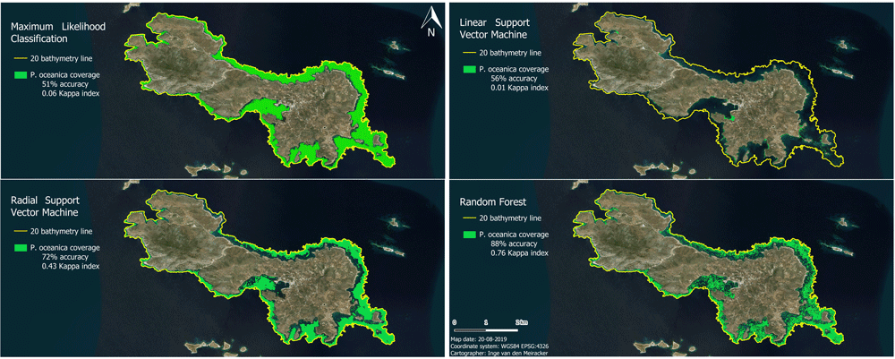
Mapping the Subsea Forests of the Mediterranean
Inge van den Meiracker writes about her research internship in Greece where she modeled and mapped the seagrass distribution in the Southeast Aegean Sea using sonar data, remote sensing techniques, and GIS.

Finding Pleasant Routes Using GIS
GIS is being to used to plan pedestrian routes not based on the fastest way but centered on finding the quietest, shadiest, or most pleasant paths.

Using Geospatial Analysis to Map the Optimal Places for Tropical Rainforest Restoration
Using peer-reviewed GIS datasets and remote sensing data, 88% of the needed restoration effort could focus on just six countries that are likely to help restore tropical rainforest growth.

Platforms for Making Deep Learning Easier for GIS
New tools have been developed to facilitate the integration of deep learning tools within GIS applications.
Determining Uncertainty in GIS Data
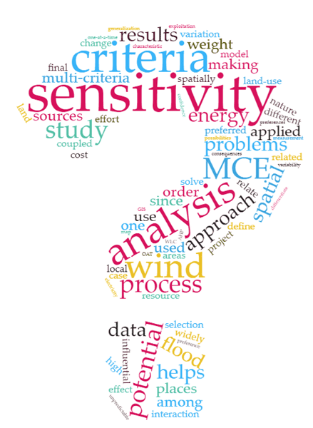
Multi-Criteria Evaluation (MCE) has widely been coupled with GIS to solve the spatial decision-making problems where there are several measures to be compared and screened for decision alternatives.

Using Crowdsourcing and Deep Learning to Map Human Settlements
Machine learning techniques are being used to map new urban and land use patterns that were previously difficult to detect using crowdsourcing data.
Uber’s Open Source Mapping Tool
In 2016, kepler.gl, Uber’s mapping tool used to track and map journeys on its popular ride hailing application, was released as an open source project by the company.

Working with GIS Data using Python
Explore how Python, a scripting and programming language, enhances problem-solving across spatial sciences, from GIS data handling to visualization.
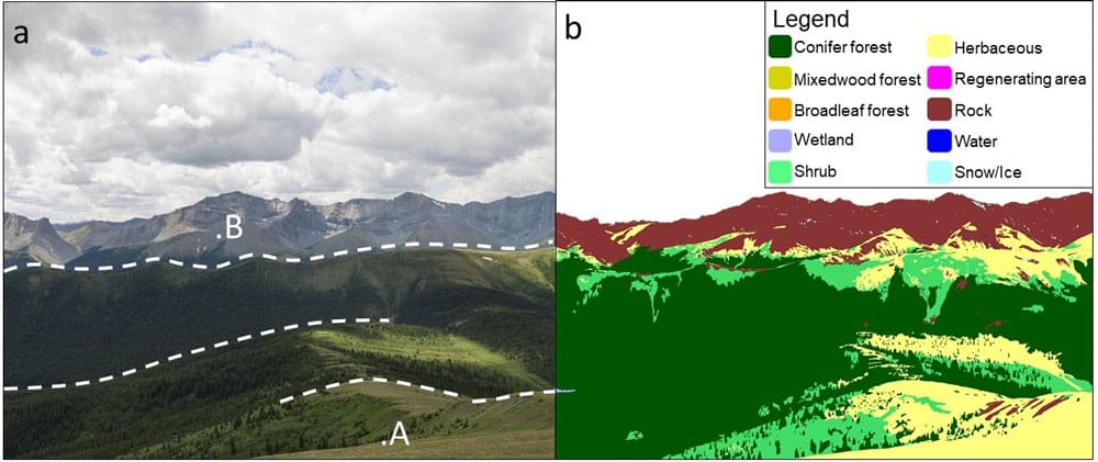
Using Historical Photographs to Map Landscape Change
Researchers used historical photographs, some dating back to the mid-19th century, to analyze changes in landscapes.
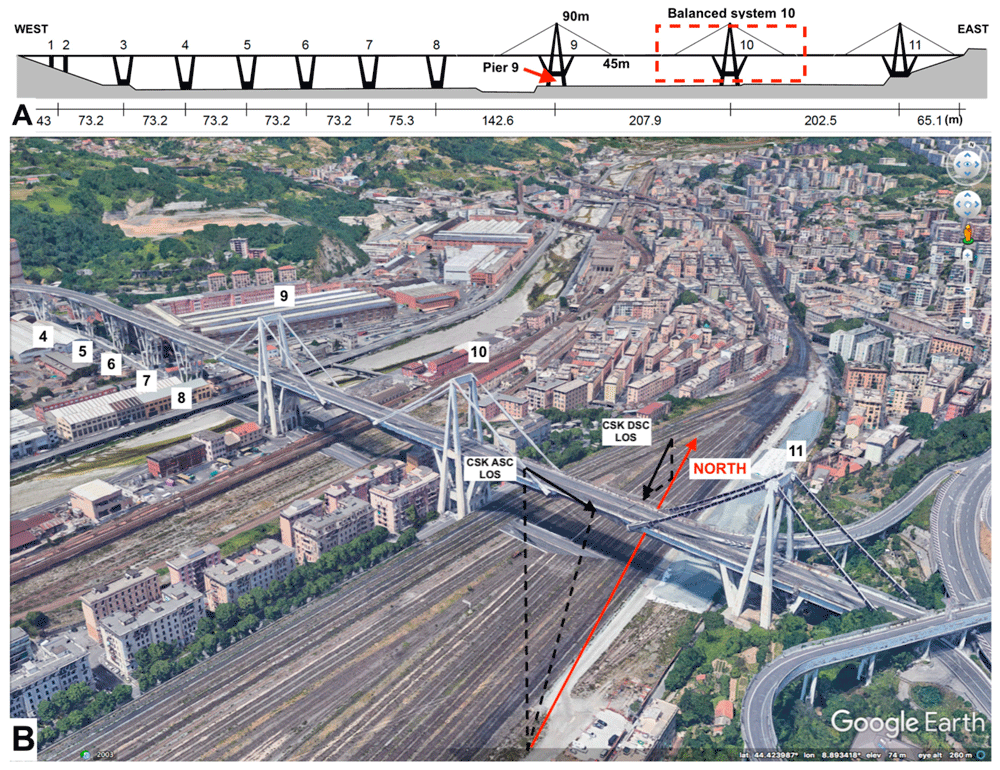
Using Remote Sensing to Detect Structural Changes in Bridges
Researchers are using synthetic aperture radar (SAR) collected from satellites to detect structural changes in bridges.

Gini Coefficient and GIS: Mapping Income Disparities
The Gini coefficient is a long-standing measure used by major organizations, such as the UN and government entities, to measure disparities between income and wealth in countries.

Mapping Migration Based on Search Data
Researchers have create ways to map migration based on online searches of migrants as they prepare to leave their country of origin.

Real-time Fire Mapping and Satellite Data
New satellites and improved image processing methods are better enabling the ability to provide real-time and near real-time mapping of wildfires.

Using GIS to Analyze People’s Attitudes
GIS can help researchers analyze spatial data within social media posts in order to understand how people react to different features in their environment.

Mapping School Performance and Inequality With GIS
With GIS, researchers can look at how effective schools are relative to spatial measures.

How Archaeologists Used GIS to Explore Sounds of the Past
Two archaeologists used GIS tools to model the ancient soundscape of New Mexico’s Chaco Canyon.

Using Machine Learning and Surface Deformation Data to Predict Earthquakes
There is no easy solution for earthquake prediction, but machine learning in particular has made forecasting far better.

GIS and Named Entity Recognition: Identifying Geographic Locations in Text
New methods in natural language processing are being developed that are merging geographic information with basic texts and human language.
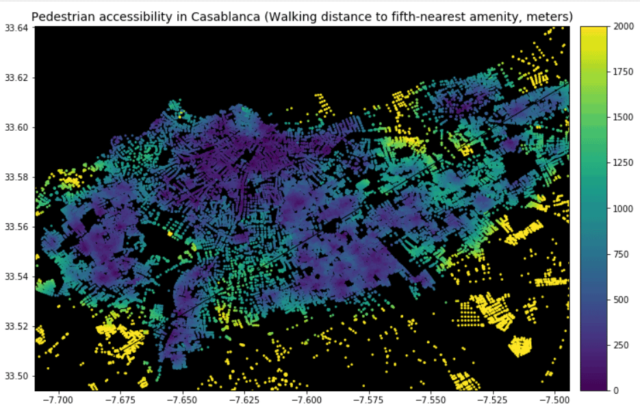
Using GIS to Analyze Pedestrian Accessibility
GIS tools to compute pedestrian accessibility are not just available to governments, academics, or companies, but are also free and open source.

Free Urban Planning GIS Book and Exercises
An open access book focusing on the use of GIS in sustainable urban planning and management includes six chapters containing exercises and GIS data.

Using Satellite Imagery to Track Volcanic Ash Clouds
Researchers have developed an algorithm that can distinguish between volcanic and non-volcanic clouds using high-resolution satellite imagery.
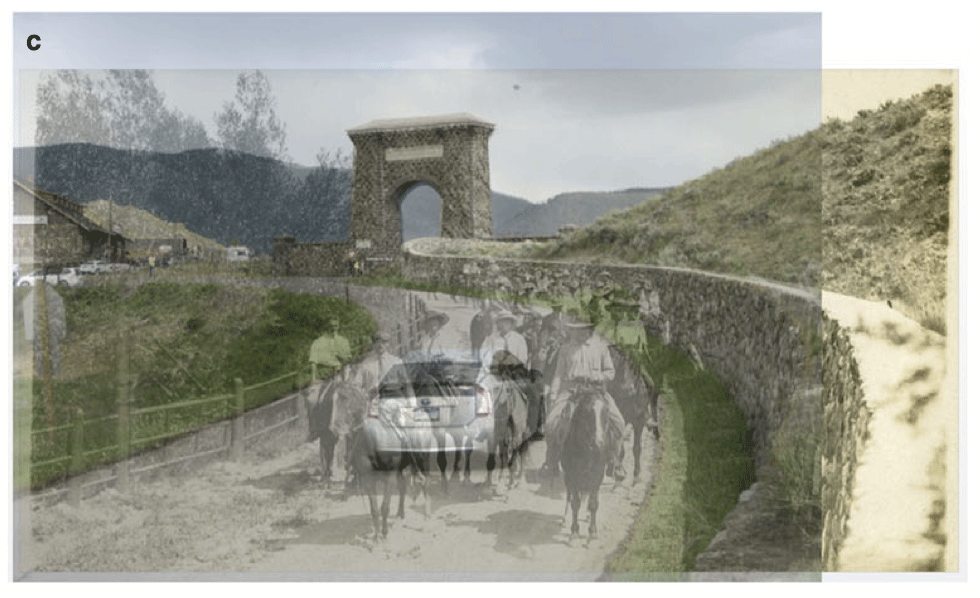
Using Ground-level Imagery to Map Landscape Change
Ground-level photographs have great value to demonstrate landscape change from a human eye-level perspective.

Mapping the Progression of Invasive Species with Crowdsourced Data
Researchers have mapped out approximate 48,510 harlequin ladybird (Harmonia axyridis) sightings – all obtained through participation of the public – over the course of a decade.

Using Satellite Imagery to Map Obesity Rates
One study recently looked at about 150,000 high resolution satellite images of cities in the United States along with census data of these areas in order to understand obesity rates in the built environment.

Tracking Post-Storm Water Movement Using GPS
NASA researchers recently published a study which uses GPS technology to track water volume and movement post-Harvey