
Spatial Analysis
The spatial analysis category looks at data manipulation techniques in GIS.

Forecasting Cholera Using Remote Sensing
The NASA cholera forecasting tool effectively takes satellite observations on environmental conditions and combines the data with information on infrastructure and conditions in a country.

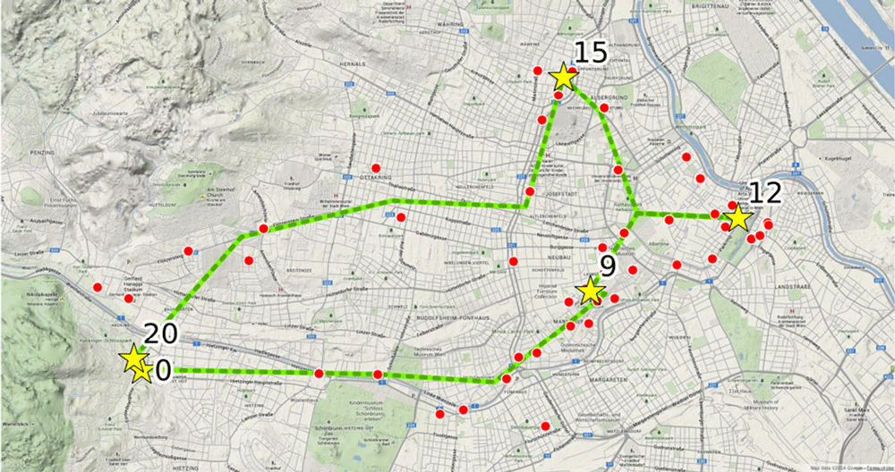
Mapping the Best Route for Pedestrian Safety
A team of researchers has published a study that calculates the best pedestrian route based on safety over finding the shortest route.

Startups and the Future of Spatial Analysis
A growing number of startups are developing new approaches to advanced spatial analysis for everyday solutions across many fields and industries.

Seeing the World with Data: 3D LiDAR with MapD and Uber’s deck.gl
Dipti Kothari, an intern with MapD, has developed an open source project that uses LiDAR to create a 3D visualization of tree coverage around buildings and the impact of rising sea levels on buildings on Jekyll Island, GA.

Ready for Summer – Remote Sensing of Bathing Water Quality
Remote sensing is being used to help researchers monitor water quality in lakes and coastal areas.
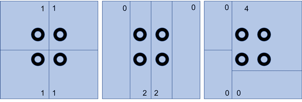
The Modifiable Areal Unit Problem and GIS
For most GIS practitioners, modifiable areal unit problem (MAUP) is something to be aware of when different analytical techniques are applied.

Mapping and Assessing Landscape Suitability for Bee Migration
Research highlights how GIS and remote-sensing techniques can be used to evaluate and map areas that are suitable for bee populations.
Using Cell Phone Data to Map Urban Activity Patterns
Mapping mobile cellular data has a major potential in allowing a better understanding of how we use urban spaces, including transport networks and access to events and venues.

Monitoring and Mapping Microplastics in Marine Ecosystems
Advancements in satellite remote sensing techniques are paving the way toward the development of high resolution and temporal maps of marine microplastic distribution.

Detecting Flooded Roads From Satellite Imagery
Mapping flood damage by manually examine imagery is a time-intensive and expensive process. New, automated methods using satellite data that compare pre and post-flood conditions are being developed.

Using GIS to Study Gentrification
Amid US gentrification trends, municipalities are increasingly using GIS to study its impacts.

Visualizing Temporal Data with GIS
While mapping spatiotemporal data has remained a challenge, increasingly we are seeing tools that are available on common open source platforms (e.g., R statistical package and QGIS) or commercial platforms such as ArcGIS.

The Role of GIS in Predicting Road Conditions
Recent developments in GIS and analytical applications have demonstrated that predicting road conditions, and thus preventing traffic accidents and possibly even traffic in the first place, is possible.

Researchers Analyzed over 22 Billion Shipping Positions to Map the Global Footprint of Industrial Fishing
To map out global fishing activity, over 22 billion AIS messages between 2012 and 2016 were analyzed by researchers.

Transforming Satellite Imagery Classification with Deep Learning
Deep learning has a potential to transform image classification and its use for the spatial sciences, including GIS.

Monitoring Algal Blooms with Remote Sensing
Given the importance of knowing how blooms affect aquatic life, remote sensing techniques using a variety of available imagery have been developed.
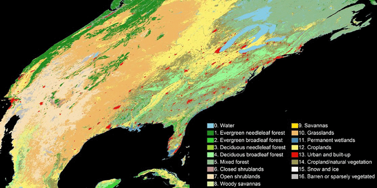
An Algorithm to More Accurately Classify Land Cover Using Landsat Imagery
Hankui Zhang, from South Dakota State University, has developed a new classification technique that combine satellite images from MODIS and Landsat.

GIS and Territorial Disputes
The use of GIS for mapping territorial disputes has played both a positive and negative role in resolving these disputes.
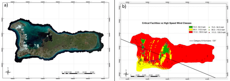
Predicting and Assessing the Impact of Hurricanes with GIS
GIS has become an important tool in assessing the risk of hurricanes and estimating the impact of damage that they may cause.

Cost Distance and GIS
GIS can be used for cost distance mapping by factoring a variety of variables, ranging from economic, social, cultural, environmental, or other barriers to analyze the ‘cost’ in travel or movement.

Introduction to Density Mapping With GIS
Density mapping shows where points or lines are concentrated. GIS tools like ArcGIS and QGIS provide point density analyses.

Creating a Time Series Visualization of Two Decades of Changes in a Glacier
NASA has created a time series visualization of Greenland’s Helheim Glacier using 20 years of data from radar, lasers, and high-resolution cameras.
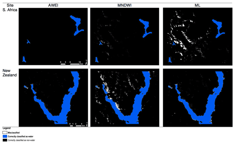
Automated Land Cover Maps
Automating the generation of land cover maps from satellite imagery is becoming easier due to learning-based algorithms improving the understanding of signal data.

Researchers are Using Machine Learning to Better Predict Weather Patterns
The enormous amount of data from Earth-observing satellites is pushing researchers to use machine learning to mine the information and improve climate models.
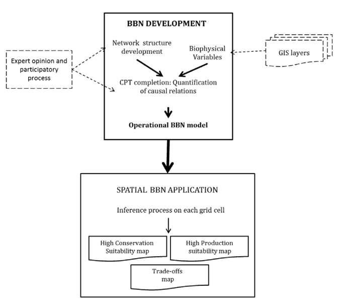
GIS and Bayesian Belief Networks
Bayesian belief networks (BBN) and GIS can be used as decision aides to give an idea of probability of events unfolding.
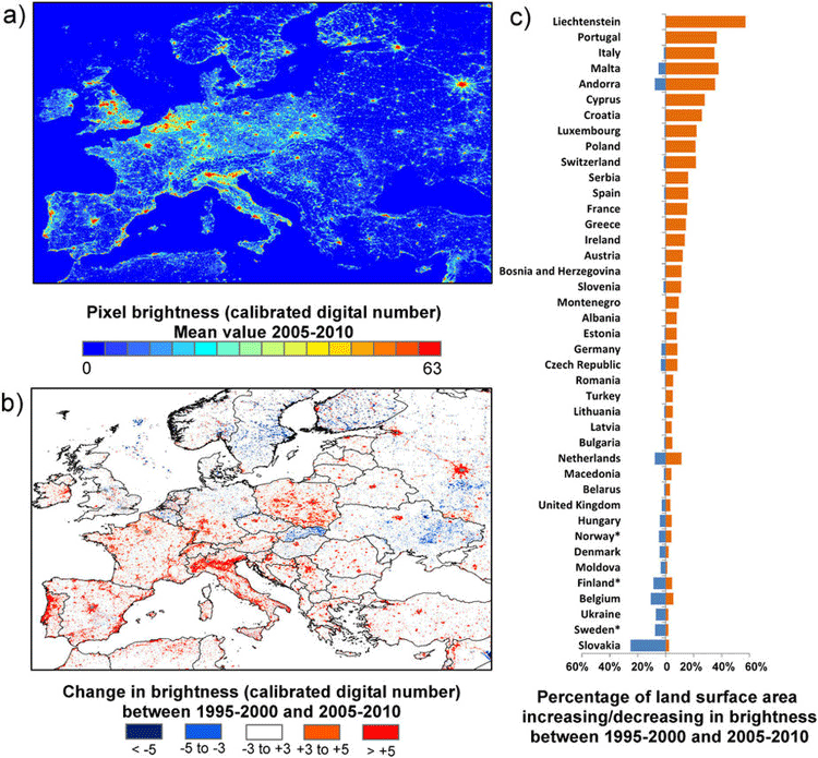
How Geospatial Technologies Are Being Used to Study Light Pollution
Spatial technologies, including remote sensing and GIS, have been used to monitor light pollution and its associated degradation effects.