
Articles
GIS Skills
What skills are needed to be a successful GIS professional? Broken down by category, listed here is an in progress ...

Geospatial Technologies in Precision Agriculture
Discoveries in the field of science and technology have enabled farmers to effectively use their input to maximize their yield.

Data Capture in GIS
This article provides a brief overview of the GIS data collection process along with examples of methodologies for GIS data ...
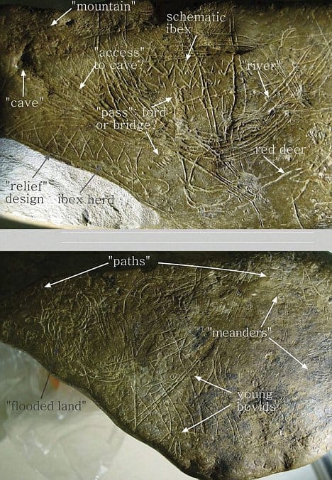
Geoarchaeology
Geoarchaeology uses geospatial technologies such as GIS in combination with human, physical, and environmental concepts pulled from Geography and Geology.
How to Cite GIS Materials
How do you cite GIS materials such as map, GIS data, and GIS software? Listed here are examples on how to cite GIS work.

Aerial Mapping with Balloons, Kites, and Pigeons
While aerial photography today is most commonly captured via an airplane fitted with cameras, aerial imagery in the past required more inventiveness with photographers using balloons, kites, and pigeons.

Geography of Coffee
To geographers, coffee holds a number of intriguing chronicles relating to physical geography, human geography, biogeography, and many other aspects.

Gretchen Peterson | Profiles From the Geospatial Community
Gretchen Peterson is a well-known geospatial professional who has run her own GIS consulting firm, Peterson GIS, since 2001.

How Can Looking at Hurricane Tracks Help to Understand Them?
Robert Lang's GIS tutorial employs public hurricane mapping sites to comprehend hurricane tracks, with exploratory questions incorporated within the tutorial steps.

Time and GIS: Ways of Representing Time on a Map
Spatialtemporal visualization are ways to illustrate changes in an area over time on a map. The famous geographer Immanuel Kant maintained that geography was the study of knowledge in a location, while history was the study of knowledge in time. This article explores different cartographic methods of showing changes in time over space on a map.
Hurricane Isaac Mapped
Projected to make landfall tonight at the southwest pass of the Mississippi River, a recently reclassified Hurricane Isaac has a lot ...
Excel Mapping with ArcGIS Online
Esri recently debuted the availability of Esri Maps for Office, a new component of its ArcGIS Online service that allows ...
Geography of Ancestry
What’s your geographic ancestral origin? A team of researchers from Tel Aviv University (TAU) and University of California, Los Angeles ...
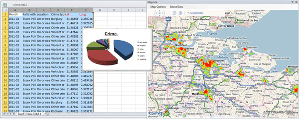
Making Maps With Excel
There is a huge amount of untapped geographic information stored within Microsoft Excel spreadsheets. With over one billion users of the popular spreadsheet software, that is a lot of data waiting to be mapped out. That said, the capability of mapping out that geographic data doesn't necessarily need to be done through an external desktop GIS software application. There are a few solutions on the market that provide both free and cost-based mapping solutions that operate directly within Excel.
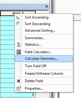
Calculating Polygon Area in ArcMap
Here are the steps for calculating the area of a polygon using ArcGIS.

Inequality Tutorial Using Instant Atlas
This tutorial looks at how the Instant Atlas map viewer allows the user to compare different areas in the UK.
What Do GIS Professionals Make: GIS Salary Surveys
What are the average salaries for a GIS Analyst, GIS technician, or GIS manager? Finding out that answer depends on a variety of factors from the industry the job is located in, years of experience, and education level of the GIS employee. Salaries also vary greatly by region/ The best way to get an estimate as to your earning power based on your location, experience, and field of interest is through GIS salary surverys.

Map Theft and Map Thieves
As with most objects that carry a potentially large price tag, rare and valuable maps have been subjected to theft ...

Geography of the Olympic Rings
The interlocked Olympic rings were meant to symbolize the Olympics' universality and to promote international harmony.

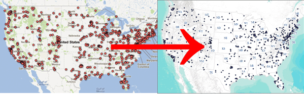
Where are the GIS Jobs? A Look at the GIS Job Market in the United States
The best way to answer where GIS jobs most frequently occur is to map out the location of GIS related jobs to see where, geographically within the United States employers are hiring.
How to Convert a KML File into an ArcGIS Compatible Format
This quick tutorial shows you how to convert a KML file so you can add it to ArcGIS.

GIS Guide to Public Domain Data
Esri Press has released a new book called The GIS Guide to Public Domain Data.
Armchair Geography
Geospatial technology has allowed users the ability to travel the world without ever leaving home. Users can explore the world, ...

Map as Art
There are many amazing examples of artists who turn to cartography and geography for inspiration. Whether through the lens of ...

Making Maps with Google Fusion Tables
Learn about making maps using Google Fusion tables.