
Articles

Spatial Unmapped
Geographic maps aren't the only means by which to communicate spatial information.

QGIS: Introducing the Quantum GIS Ecosystem
Anita Graser provides an introduction to the desktop, web, and mobile capabilities of the open source GIS software, QGIS in this guest article.

How To Make Area Cartogram Maps in ArcGIS
If you have data with disparate values between areas, making an area cartogram is an effective way to map out those values. This article provides a tutorial on how to make area cartogram maps using ArcGIS.

Arkansas – Geography and Geology
Individuals in the U.S. don’t have to travel very far to find topographical change. We are surrounded by a variety ...

Interactive Maps of Billionaires
Three interactive maps showing the locations of billionaires around the world.
Geography of Billionaires: Mapping Nationalities and Residency
Forbes recently released an updated list of the world’s billionaires. The listing contains the ranking for 1,226 individuals and families ...
Geography of Billionaires: Total Counts of the World’s Billionaires by Country for Residency and Citizenship, and by City
This article contains the tables covering the statistics used in the Geography of Billionaires: Mapping Nationalities and Residency.

Crime Mapping and Analysis
The advent of easy-to-use GIS applications has allowed crime mapping and analysis to flourish within law enforcement agencies.

Area Cartogram Maps Explored
Area cartogram maps are maps of non-absolute space where the areal extent is in proportion to some measured value. Cartogram ...

GIS Skills and Landscape Architecture Education
The March 2012 Landscape Architecture Magazine revealed that while GIS is crucial for large-scale land planning, some landscape architecture schools do not require students to learn geospatial technologies.

Using GIS to Showcase College Acceptance
Every June, my local paper is filled with the local private school announcements containing lists and lists and lists of ...

Mapping Emancipation Events during the Civil War
"Visualizing Emancipation," the first interactive map showing the end of American slavery during the U.S. Civil War, has been launched by the University of Richmond’s Digital Scholarship Lab in partnership with geospatial analysis (GIS) software development company Azavea.
Titanic Mapping
April 15th marks the 100th anniversary of the sinking of the Titanic in the North Atlantic Ocean. Esri has created ...
Envisat Satellite Malfunctioning
Envisat, the European Space Agency’s (ESA) earth observation satellite, has stopped functioning properly. Communication with the satellite was lost on ...
GIS and Sustainability Efforts
GIS continues to grow in several areas that will enable it to be an essential tool in designing the sustainable buildings of the future.
Paraná River
The Paraná River runs 3,030 miles through Brazil, Paraguay and Argentina. It originates at the junction of the Paranaiba and the Rio Grande rivers. ...
Mississippi River
The Mississippi River is the second longest river in North America. Bodies of water from 31 contiguous states drain into ...
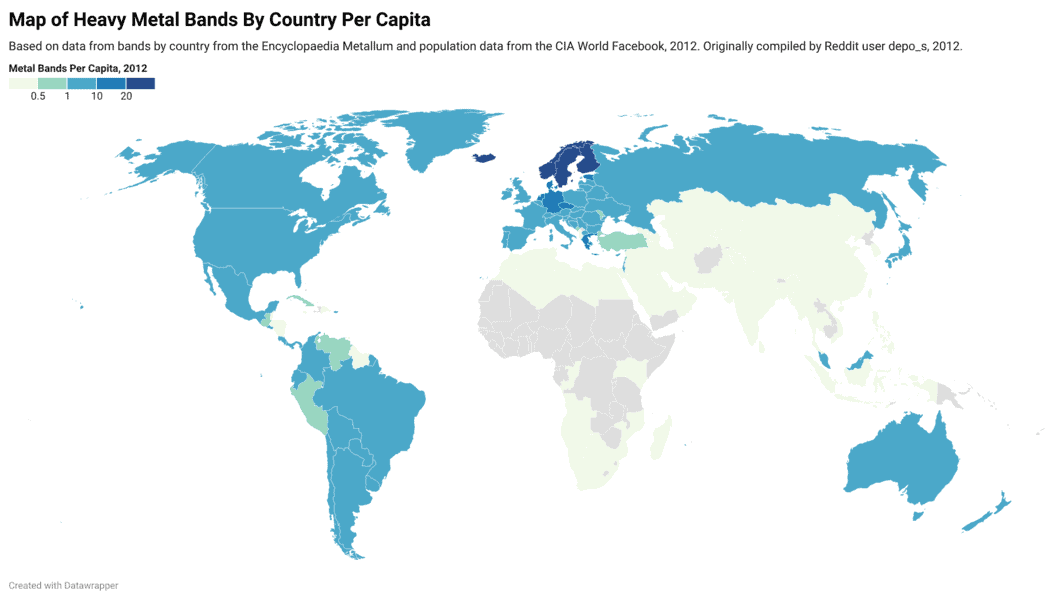
Interactive Map of Heavy Metal Bands By Country Per 100,000 People
Map and table showing where heavy metal bands are the most dense when compared against a country's total population.

Mapping the World at Night
Earth observation satellites are tracking nighttime lights around the world.

Mount Everest is the Biggest Mountain in England?
If you're one of six out of ten adults in the United Kingdom, apparently you believe that either Mount Everest, Snowdon, or Ben Nevis is the answer to "What's the Biggest Mountain in England?"
Ryan Resella | Profiles from the Geospatial Community
In this GIS interview, Ryan Resella discusses his experience as an inaugural fellow with Code for America last year and his outlook on geospatial technologies.
Moving Beyond Waiting for GIS’ Sally Field Moment
To say the least, I was mildly boggled when I noticed that Slashgeo.org was running a poll on “Is Geospatial ...

OpenStreetMap: Grassroots Mapping
OpenStreetMap was founded with the goal of creating and providing free geographic data to whoever wants it.

Distance Decay and Its Use in GIS
Distance decay is a phenomenon observed between locations or ethnic groups- the further apart they are, the less likely it is that they will interact very much. Distance decay theory in GIS can be used for other purposes such as the effects of time and distance on public transportation ridership, crime analysis, and health care.
Getting Started With QGIS: Open Source GIS
Quantum GIS is an open source GIS desktop software more popularly known as QGIS. QGIS 1.0 was first released in ...
Ultima IV Map Exhibition Preparation – GIS in Imagery Series
The Smithsonian American Art Museum is featuring an exhibition entitled The Art of Video Games which is set to run ...