
Articles
Spatial Analysis in GIS
Geographic information systems uses spatial analysis in order to understand geographic questions. Listed here are geographic analysis commonly performed in GIS.

Exploring Map Projections
Created using D3, Map Projection Transitions provides an excellent way to visualize a wide range of map projections. The page ...

Statistical Surfaces in GIS
This looks at some statistical analysis in GIS. A statistical surface is any geographic entity that can be thought of as containing a Z value for each X,Y location.

How to Translate GIS into Different Languages: GIS Around the World
How is "geographic information systems" translated into different languages?
Typefaces for National Geographic Maps
The National Geographic Society is renowned in part for its stunning maps, each labeled in incredible detail. The distinctive lettering ...
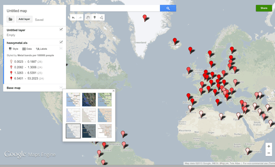
Make Your Own Maps with Google Maps Engine Lite
Google Maps Engine Lite is a simpler version of the Google Maps Engine that allows users to create and share their own maps.

Mapping Social Vulnerability
Oxfam America has released new maps about the geography and the people of the US Southeast, specifically Louisiana and Mississippi. This project ...

Measuring Earthquakes from Space
Up until recently, seismometers have been a strictly Earth-bound devices, diligently tracking each and every change in the Earth’s surface ...


Crumpled Maps and Backward Globes
Palomar, an Italian company, innovates map and globe design with unique features like crumpled maps, Odnom globes, and pin city/world maps.

Explore John Snow’s Cholera Map using GIS Data
John Snow's well known cholera map is often cited as one of the earliest known examples of using geographic inquiry to understand a health epidemic although his famous dot map was actually created after the cholera epidemic to show disease clusters.
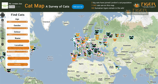
Cat Map
With over 11,000 cat locations mapped to date, the Cat Map is a crowd sourced survey of domestic feline

Grassroots Aerial Mapping
Aerial imagery has evolved into a more complex and sophisticated enterprise with most aerial imagery today being captured by aircraft ...

Map of Cardinals
Eligible cardinals from around the world are gathered in the Vatican for the papal conclave.

Spatial Orientation and the Brain: The Effects of Map Reading and Navigation
Map reading and orienteering are becoming lost arts in the world of global positioning systems (GPS) and other geospatial technologies. What are the effects of navigation and map reading on the brain?
Introduction to GIS
The fundamentals of GIS involve an understanding about data types, projections, data quality (accuracy and precision), how to collect data ...

Converting Shapefiles to Google Fusion Tables
Learn how to import shapefile GIS data directly into Google Fusion tables.
GIS Organizations
Joining a GIS organization is a great way to network and to exchange ideas. There is a growing number of non-profit and industry specific groups to choose from.

Mark Greninger | Profiles from the Geospatial Community
Mark Greninger, the GIO for Los Angeles County since 2006, shares his views on the GIS field in the latest Profiles from the Geospatial Community.

Attribute Data Types for GIS
There are two components to GIS data: spatial information (coordinate and projection information for spatial features) and attribute data. Attribute ...

Robotic Mapping: Simultaneous Localization and Mapping (SLAM)
Simultaneous localization and mapping, or SLAM for short, is the process of creating a map using a robot or unmanned vehicle that navigates that environment while using the map it generates

Tracking Global Vegetation with Micro-Satellite Proba-V
The ESA, also known as the European Space Agency, has managed to do a lot of amazing feats in the ...

Making Maps with D3
D3 is a JavaScript data visualization library using HTML, SVG and CSS. D3 stands for Data Driven Documents and was developed by Mike Bostock, ...

Wearable Cartography – Portable Mapping System
Researchers from MIT’s Computer Science and Artificial Intelligence Laboratory have developed a portal mapping system that transmits remotely a digital map ...

Map of the 2010 Census Using Dots
A map of the 2010 Census was created by Brandon Martin-Anderson, who assigned a dot to each of the 308,450,225 people counted.