
GIS and Geospatial Technologies
Articles focusing on the application of geographic information systems (GIS), geospatial technologies, remote sensing, LiDAR, and Global Positioning System (GPS). These technologies serve as critical tools for understanding and interacting with our physical environment. GIS allows for the mapping and analysis of spatial data Geospatial technologies refer to the various tools used to measure and analyze Earth’s lands and resources. Remote sensing provides a way to collect data from a distance, often via satellites or high-flying aircraft, and is commonly used for environmental monitoring and military applications.
GIS subcategories :
GIS Career | GIS Data | GIS Industry | GIS Learning | GIS Software | GPS | Remote Sensing | Spatial Analysis

Who Coined the Phrase Geographic Information System?
The phrase Geographic Information System was a term promoted by Roger Tomlinson back in the 1960s.

Fun Map and Geography Themed Gifts for 2012
The gift giving season is upon us. So, what to get for that Geogeek or map aficionado? [accordion] [toggle title=”Disclosure ...

New Map of the Earth’s Night Lights
NOAA has released an updated map of the Earth, showing light sources at night from street lights, oil and gas drilling, wildfires, volanic activity, and skyglow.
Change Detection in GIS
Change detection in GIS is a method of understanding how a given area has changed between two or more time ...
Turn Restrictions Simplified
Tim Hirrel takes a look at a new method for implementing turn restrictions in GIS street data.
World GIS Data
Looking for global GIS data? Listed here are free sources for finding GIS data in both vector and raster formats ...
GIS Techniques
Listed here are GIS techniques covering GIS data creation and manipulation, geoprocessing, mapping and spatial analysis.

Twitter Map of the Last One Million Tweets
Want to see where the most recent one million geolocated tweets were posted from? The One Million Tweets Twitter map ...

Help Classify Images of Hurricane Sandy Damage
Volunteers are needed to classify images of Hurricane Sandy to help FEMA. The site is using open source image sorting ...

Hurricane Sandy Maps with Open Data and GIS Publication Platforms
This guest submission by Chris Brown, CEO of MangoMap, takes a look at how open data and online GIS publication ...
The GIS Career, Revisioned
GIS tools and software applications are becoming more intuitive, more user friendly. There is a mindset that is slowly being ...

Where is the Phrase “80% of Data is Geographic” From?
Those that work in GIS data have probably heard the phrase "80% of data is geographic". What is the origins of this phrase, and is it true?

Mapping Hurricanes
Information about embedable hurricane maps, historic hurricane tracks, and the top list of most damaging hurricanes from NOAA.

The Many Modes of Google’s Street View Program
Google’s street level imagery gathering is an enormous data collecting effort. Street View launched in May of 2007 and Google ...
Dos and Don’ts of Web Map Design
The proliferation of easy to use tools and web services has brought web mapping a long way from its origins. ...
Basic Geographic Concepts
Listed here are the basic geographic concepts for geographic understanding and inquiry. When looking at the geography of an area, ...
What Can You Do With GIS?
As well has having significant application in the worlds of business and commerce and natural resources the largest pool of ...
Geographic Analysis with GIS
The vast majority of information present in the world has some form of spatial element connected with it. A geographic ...
GeoSocial Interactive Map for Transportation Project Planning
This week a spectacular conference aimed towards transportation professionals is being held in Los Angeles called Rail~Volution. The aim of ...

GIS and Natural Resource Management
Peter Rodericks Oisebe, a Natural Resource Management Consultant in Kenya writes about the applications of GIS in mapping and managing natural areas.
SDTS – GIS Data Standard
SDTS stands for Spatial Data Transfer Standard. SDTS was a standard for transferring earth-referenced spatial data across disparate computer programs. The U.S. ...
GIS Skills
What skills are needed to be a successful GIS professional? Broken down by category, listed here is an in progress ...

Geospatial Technologies in Precision Agriculture
Discoveries in the field of science and technology have enabled farmers to effectively use their input to maximize their yield.

Data Capture in GIS
This article provides a brief overview of the GIS data collection process along with examples of methodologies for GIS data ...
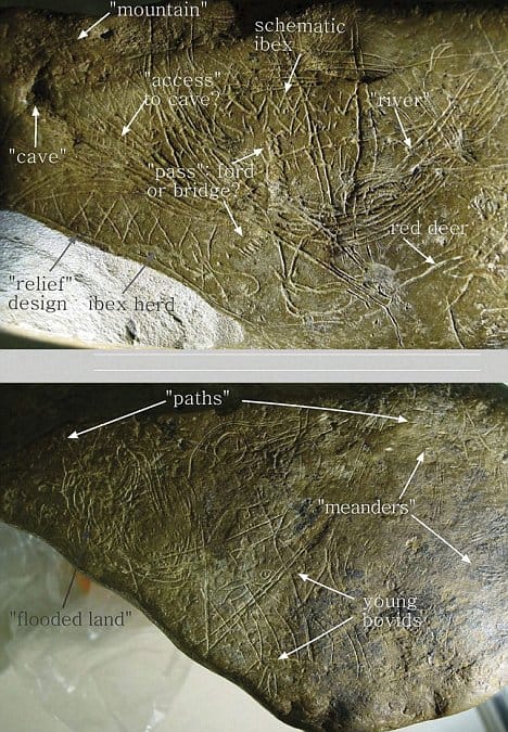
Geoarchaeology
Geoarchaeology uses geospatial technologies such as GIS in combination with human, physical, and environmental concepts pulled from Geography and Geology.
How to Cite GIS Materials
How do you cite GIS materials such as map, GIS data, and GIS software? Listed here are examples on how to cite GIS work.