
Physical Geography
Physical geography focuses on geography as an Earth science (and is sometimes called Earth System Science).
Physical geography is a branch of geography that focuses on the study of the natural features and processes of the Earth’s surface. It includes the examination of landforms, climate, vegetation, soils, and water resources. Physical geographers use a range of scientific methods and tools to analyze and understand the complex interactions between the Earth’s physical systems.
Learn about the different branches of geography that fall under the physical geography category: climatology, geomorphology, biogeography, and more.

Aral Sea Continues to Shrink
Once the fourth-largest inland water body in the world, the Aral Sea shrank again in 2013
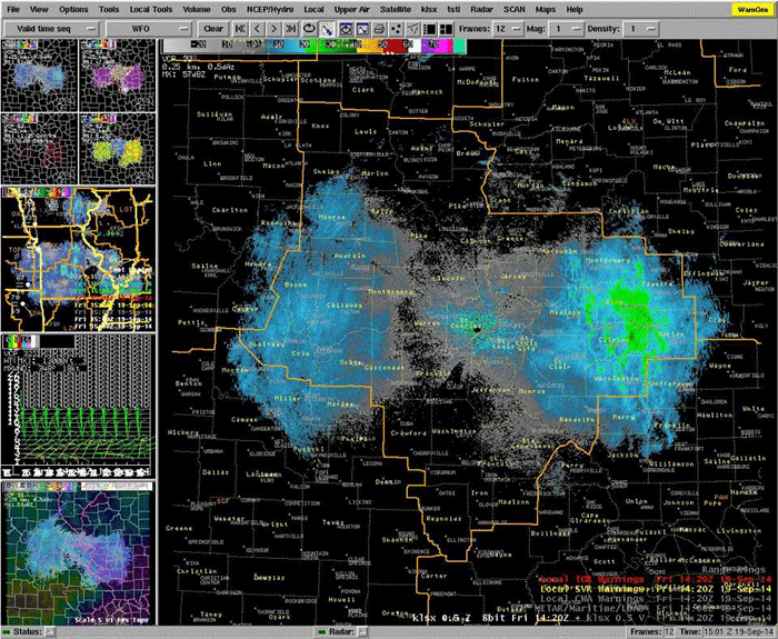
Mass Movements So Large You Can See Them on Radar
The U.S. National Weather Service in Saint Louse, Missouri recently reported that a butterfly shaped pattern on its radar was the result of... butterflies.

Animal Navigation Through Magnetoception
Magnetoception is the ability for certain animals to orient themselves based on the earth’s magnetic field.

Mapping Iceland’s Bárðarbunga (Bardarbunga) Volcanic Eruption
The second highest mountain in Iceland has been exhibiting heightened activity since mid-August. As a results causing thousands of local ...

Geography of Impact Craters
According to the Earth Impact Database, there are currently 184 verified impact craters that have been documented on Earth.

Impact Craters
Impact craters are the result of an object hitting a larger surface at hypervelocity creating a circular depression in the ...

Centennial of the Extinction of the Passenger Pigeon
September 1, 2014 marks the hundred year anniversary of the extinction of the Passenger Pigeon. Passenger pigeons were once the ...

Tracking the Effects of Drought in the Western U.S. with GPS
The effects of the drought that has stricken the western United States can be measured with GPS. As anyone who ...

Rud-e-Gaz and Rud-e-Hara Wetlands, Iran
This satellite image captured of southern Iran shows what an arid and inhospitable area most of this region is.

Tule Fog Declining in California’s Central Valley
A group of researchers analyzed satellite imagery over a 33 year span to establish an understanding of the fog climatology in the Central Valley.

Tonle Sap Lake – One of the World’s Most Productive Freshwater Ecosystems
Located in Central Cambodia, Tonle Sap Lake is the largest lake in Cambodia and is considered one of the world's most productive freshwater ecosystems.

Where is the Only Area in Europe Where no Borders Exist?
Lake Constance's shoreline touches three different countries: Germany to the north, Switzerland to the south and Austria at its eastern end. The water body itself contains no borders since there is no legally binding agreement between the three countries.

Aralkum Desert: The World’s Newest Desert
Replacing the shrinking areas of the Aral Sea, the Aralkum Desert is located in Uzbekistan and Kazakhstan, making it the world's youngest desert.

Unique Features of the Australasian Geographic Zone
Australasia is a unique geographical and ecological zone compromised of Australia, New Zealand, New Guinea, and other small islands nearby.

Introduction to Climate Change
Changes that are normally brought about by climatic variations have caused major environmental concerns worldwide. These changes without doubt bring ...

National Climate Assessment Report Released
The National Climate Assessment, an important report on the impacts on climate change in the United States today and in ...

Richat Structure: A Geologic Wonder
The Richat Structure, a geologic wonder viewable from space, is a striking circular feature found in the Sahara Desert in ...
How Deforestation Affects Physical Geography
Deforestation is a problem we are likely all familiar with, even in passing. We drive or walk by small or ...

How Rivers Change the Landscape
Rivers twist and turn, shaping the environment around them just as the physical geography of the surrounding landscape shapes them.

Volcanoes and Glaciers in Iceland
Iceland is a country of varied geography, topography, and landscape.

Aquatic Dead Zones
Aquatic dead zones are bodies of water where the oxygen conditions are so low that marine life is unable to be supported.

Changing Geography of the Dead Sea
We’ve all seen the pictures- tourists floating in a picturesque lake surrounded by a mountainous desert environment, calmly reading flipping ...

Underwater Global Warming
Scientists are using satellites and remote sensing to better understand changes in sea-surface temperatures.
Satellite Imagery Maps Out How Bad the California Drought Really is in 2014
California has been suffering from historical drought conditions. Almost all of California is experiencing drought conditions. Many parts of California ...

The Grand Canyon
The Grand Canyon is one of America’s most beloved and well-known geographical wonders and is visited by millions of people every year.

Structure of the Earth
Listed here are quick facts about the earth's crust, mantle, and core.