
Articles
GIS Developments in India – Year 2000 Analysis
The year 2000 was a tremendous time for GIS users in India even though the developments were in a juvenile ...
GIS 2000: A Brief Look Backwards
While anticipating the events of 2001, this article takes a brief look at some of the notable GIS and geospatial events of 2000.

Remote-Sensing Technologies
Remotely-sensed imagery from aircraft and satellites represent one of the fastest-growing sources for raster GIS data.

Campaign 2000 – the Recount
A spatial look at the nail biting vote recount in Florida that will decide the winner of the 2000 U.S. presidential election.

Campaign 2000 – A Cartographic Perspective
A look at the 2000 US Presidential election through campaign maps.

Gateway into Bali
Gateway into Bali is an interactive, guided tour of GIS using this colorful Indonesian island as the backdrop.
How to Create a Password Login For ArcView 3x
If you want to require users to login with a password before being able to use ArcView here's a simple way.
Creating Html Pages on the Fly Using Avenue
You can use Avenue to write html code in order to create html pages on the fly. In the Avenue ...

Vector GIS Product Categories
This article categorizes GIS software by use, into four categories: desktop mapping, data viewers, components, and internet mapping.
National Map Accuracy Standards (NMAS)
Definition: Standards established in 1941 by the U.S. Bureau of the Budget to set accuracy standards for all federally produced ...
Linking MS Access With ArcView 3.x Using Avenue
The two sections of code in this article focus on using Avenue to interact with MS Access to extract and use data with ArcView.

What does it take to support a GIS?
A systems analyst discusses what it takes for the information technology group for a local government to support GIS operations.

Dr. David M. Theobald Talks About His Career in GIS, Issues in GIS Education, and the Use of GIS for Conservation
Dr. David M. Theobald is a Scientist at the Natural Resource Ecology Laboratory at Colorado State University in Fort Collins, Colorado who has been working with GIS since the middle 1980s in the areas of planning, conservation GIS, and landscape ecology.

The Geography Network
Esri launched the Geography Network as a collaborative system for sharing digital geographic information on the internet.

Introducing the ArcGIS Platform: One Look, Many Applications
Perhaps the most immediate impact for users leaving the 2000 ESRI User Conference is the announcement of the unification of the ESRI product line, called ArcGIS.
How to Add a Custom Symbol to Arcview 3x
This article will show you in easy to follow steps how to add your own image file to ArcView 3x in order to create a custom symbol.
Realizing the Benefits of an N-Tiered Enterprise GIS
This year's conference is an especially significant event in the history of the GIS industry because of several concurrent developments in technology.

Geography of Fortune 1000 Companies
Data gathered from two thousand year Fortune 1000 Company ranking was mapped in order to look at any spatial patterns in their locations.
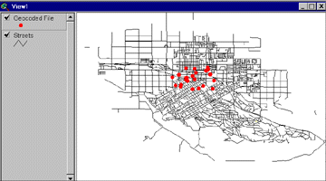
Geocoding Primer
This tutorial explains how to geocode using Esri's ArcView 3.x GIS software.

Thirty Tips and Tricks for Programming in Avenue
Some tips and tricks for customizing ArcView 3x using Avenue
Number of Year 2000 Fortune 1000 Companies by State
Number of Fortune 1000 companies categorized by state for the year 2000. The list of total count of Fortune 1000 ...
Fortune 1000 Companies By State for the Year 2000
Listed below are the Fortune 1000 companies listed by state for the year 2000. Each records lists the company name, ...

U.S. discontinues selective availability of GPS to public
On May 1, 2000, the U.S. government discontinued "selective availability", which was the intentional degradation of GPS signals.
How to Change Default Directories in ArcView 3x
After using ArcView 3x you’ve probably noticed the directory defaults. You can easily change the default temp directory, the first directory ...

The Power of Mapping
The real value of GIS come from the ability to integrate spatial information with higher end statistical and analytical processes to derive spatial patterns not readily apparent to the observer.
GIS Day: A Celebration
On November 19, 1999 thousands of businesses, governments and schools participated in GIS Day. Coming on the tail end of ...