
Articles

Orbital Insight Shows How Artificial Intelligence (AI) Can Be Used to Study Images from Space
Orbital Insights has developed a “deep learning” processes which uses artificial intelligence to pull data from satellite imagery.

Are Ecosystems That are Rich in Biodiversity More Resilient to Diseases?
An ecosystem that is rich in biodiversity is stronger and more resilient to diseases, a recent series of studies has shown.

Vegetation Helps to Lessen the Effects of Urban Heat Islands
The abundance, or lack, of vegetation in a city can have an effect on how much heat cities retain, known as the urban heat island effect.

Your Mobile Portfolio: Make it Your Own
Lowell Ballard, Director of Geospatial Solutions for Timmons Group, discusses the importance of making users feel like a part of your company's ecosystem by developing a mobile portfolio.

Changes in Light from Space
Astronauts on the International Space Station have studied the light emissions coming from older lights and newer LED lights and have found that LED lights actually make light pollution worse.

Advanced Techniques for Measuring Human Behaviors in Urban Public Spaces
Researchers at the University of Copenhagen utilized a combination of thermal cameras, computer vision technology, and GIS analytics to geo-reference the movements of pedestrians in order to asses public spaces.

Satellite Imagery Provides Insights to Global Questions and Changes the Data Landscape
Data extracted from satellite images have been helpful for tracking everything from the number of customers at retail and restaurant chains to tracking the rates of deforestation.

California is Sinking Faster than Previously Thought
Researchers are tracking the changes in California’s geography from the effects of drought using a remote sensing system called interferometric synthetic aperture radar, or InSAR.

Uber Residential Pick-Ups in New York City Reflect Demographic Realities
A report reveals that ridership rates for both Uber and cab companies in New York City are equally distributed geographically.

How Government Organizations Are Using Location Intelligence to Drive Digital Engagement
This opinion piece by James Brayshaw, Vice President of LI and Spectrum Business with Pitney Bowes, takes a look at how location intelligence is helping local governments make timely and accurate decisions.
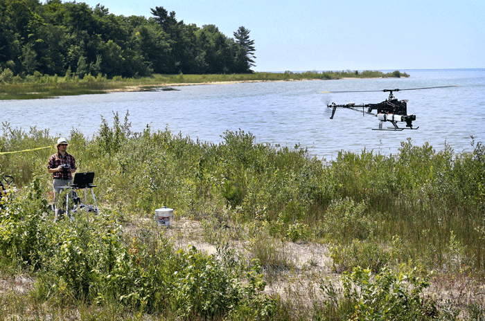
Drones and GIS: A Look at the Legal and Ethical Issues
The ethical and legal issues about gathering geographic data using drones can be divided into four main areas: regulations, privacy, safety, and noise.

This Hurricane Formed Farther East Than Any Other Since Satellites Began Tracking Hurricanes
A hurricane, dubbed Hurricane Fred, formed farther east than any other recorded hurricane since satellites began tracking such weather events

Spatial Law and Geospatial Applications
Taking a look at spatial and and geospatial applications, this is the third of a three-article series on Spatial Law that focuses on the issues surrounding spatial technologies, the responsibilities and legalities thereon.

Spatial Law and Geospatial Technologies
Taking a look at spatial and and geospatial technologies, this is the second of a three-article series on Spatial Law that focuses on the issues surrounding spatial technologies, the responsibilities and legalities thereon.

Spatial Law, Policy, and Geospatial Technologies: A Comprehensive Overview
Taking a look at spatial law and its application within GIS is the first of a three-article series on Spatial Law that focuses on the issues surrounding spatial technologies, the responsibilities and legalities thereon.

Extracting 3D GIS Data
This piece by Anil Narendran Pillai, Vice President of Geomatics at SBL, takes a look at 3D GIS data creation using feature extraction methods.

How Many Trees are There in the World?
According to the latest research, the total number of trees in the world is 3.041 trillion (that’s 3,041,000,000,000). The revised number is ...

Measuring the Number of Trees in the World
Using a combination of satellite imagery, forest inventories, and supercomputer technologies, researchers estimate there are 3.041 trillion trees in the world.

Recent Efforts to Map and Cleanup the Ocean Garbage Patches
The Ocean Cleanup has recently sent out a ship full of researchers and volunteers to help map and begin cleanup efforts on the Pacific Ocean garbage patch.
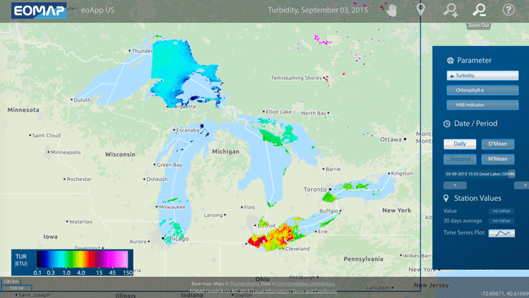
Mapping Algal Blooms in Lake Erie
EOMAP has released a mapping application designed to track algae blooms in Lake Erie.

Map of the World Without Humans
In a world without humans, elk and buffalo would roam the Great Plains and elephants might still trumpet across Europe.

Chimpanzee Behavior Analyzed Using Innovative GIS Application Offers Insight to Our Human Past
A group of scholars has developed an innovative new application of GIS to understand stone tool use behaviors in chimpanzees during nut-cracking season.
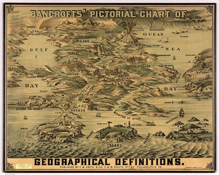
Geography Terms Visualized
This chart by the Bancroft Company from around 1870 defines a range of geographical terms.

Mapping the U.S. by Property Value and Land Area
How Urban Property Values are Adversely Affecting the U.S. Economy

The Prime Meridian isn’t Where You Think it is
The true Prime Meridian is located about 334 feet east of the current Airy Transit Circle at the Royal Observatory in Greenwich, England.

Geography of Tweets
In an analysis of ‘big data’ from Twitter, people who lived in larger cities around the world were more likely to mention other large cities or international locations.