
Articles
Urban Disaster Prevention Spatial System
Guest article from SuperGeo. SCENARIO On September 21st, 1999, a 7.3 strong magnitude earthquake rocked Taiwan. It caused thousands of ...

Views from the 2010 Esri UC
GIS professional and photographer Kristina Jacob shares photos from the 2010 Esri International User Conference

Global Forest Heights
Where are the tallest forests in the world? NASA has an article on the first global map of the world's forest heights. The map was created with data collected by NASA's ICESat, Terra, and Aqua satellites.
Goulburn Valley Water Improves Efficiency with Customized GPS Software
Guest article from Trimble. “To the left of the driveway behind the shed.” Imagine how long it takes to locate ...
Geostatistics Resources
Geostatistics is a brand of statistics that deals specifically with spatial relationships. Find information about this branch of mathematics, software ...
Six Best Sources for Local Land Use/Land Cover GIS Data
Guest article by Kristen Carney and Aaron Herman of Cubit. This article is a follow-up on “National Land Cover Data Set: When ...
Free Map Servers
Want to launch maps over the internet but can’t afford commercial software? Check here for links to free map servers.

National Land Cover Data Set: When There’s No Local Land Use GIS data
Guest article by Kristen Carney and Aaron Herman of Cubit. Finding land use land cover data is a pain. Unless your ...

Monitoring Conservation Easements and Preserve Lands with GPS and GIS Technology
Trimble discusses how they use GPS and GIS technologies to effectively manage and map over 8,000 acres of conservation land.

Mapping Out Geotagged Photos
These cartographers have mapped out geotagged photos to show areas where the most pictures by tourists have been taken.

Your Brain on Maps
What do some recent studies that look at the brain and navigation suggest? Read on to find out.
GPS and GIS Technologies Speed Assessment of Historic Sites in Post-Katrina New Orleans
In this case study, FEMA and NPS collaborated on field assessment methodology to meet National Historic Preservation Act (NHPA) requirements ...
Free Spreadsheet Geocoding
If you have a spreadsheet such as a Microsoft Excel file containing address or x,y coordinates and you want to make a quick map, BatchGeo is a free and easy online application that will convert your location data and geocode it onto Google Maps.

Matt Artz | Profiles from the Geospatial Community
Matt Artz is the editor of GIS and Science, a blog focused on "the use of GIS technology by the scientific community and for scientific applications".
Glenn Letham | Profiles from the Geospatial Community
Glenn Letham is a geospatial reporter, having first founded the Spatial News site before creating GISUser, a geospatial industry news site.

Why Geography?
The citizens of many of the world’s countries still don’t realize that ignorance of geography can affect their political stability, ...

James Fee | Profiles from the Geospatial Community
James Fee is well known for his popular GIS blog that has an active participation by the geospatial community.

National Geography Standards
A set of eighteen learning standards has been created for the science of geography which are called the National Geography Standards.

Adena Schutzberg | Profiles from the Geospatial Community
Adena Schutzberg, the Executive Editor of Directions Magazine, shares insights on the geospatial industry.
C and C++ Programming
Guide to resources to learning C and C++ with an emphasis on spatial information. Find applications based on C and ...
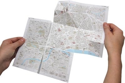
Zoomable Paper Map
Called map2, the uniqueness about this map of London is the patented folding technique that allows the viewer to either view a large scale map or to fold out sections to see the zoomed in area.

Deadly Cold Across Europe and Russia
This image shows the impact of the cold snap on land surface temperatures across the region from December 11 to 18, 2009, compared to the 2000-2008 average.
Real-time GPS Mapping and GIS Solution Aids Efficient Disaster Management
Saturday, February 7, 2009 will forever be known as Black Saturday in the state of Victoria, Australia. In the midst ...
Line in the Sand – How the Same Species Differ Across Borders
A study from the University of Haifa looked at differences between rodent, reptile, and ant lion species in Jordan and Israel.
Ordnance Survey Data to be Made Freely Available
The UK's Ordnance Survey will "will open up its data relating to electoral and local authority boundaries, postcode areas and mid scale mapping information."
First Thematic Maps
Zachary Forest Johnson provides an overview on Indiemaps.com on the first published instances of each of the six most commonly ...