
Caitlin Dempsey

Eight Online Maps in Celebration of the 50th Anniversary of the Wilderness Act
In celebration of the 50th anniversary of the Wilderness Act, Wilderness50 was launched by a coalition of agencies, organizations, and universities to help elevate wilderness protection.

Centennial of the Extinction of the Passenger Pigeon
September 1, 2014 marks the hundred year anniversary of the extinction of the Passenger Pigeon. Passenger pigeons were once the ...

Who Did the Napa Earthquake Wake Up?
Jawbone aggregated data from thousands of UP activity trackers to see what percentage of people in the Bay Area were woken up by the Napa earthquake.

Mapping the Impacts of Climate Change in California
A group of Stanford students taking a biology class entitled Geographic Impacts of Climate Change: Mapping the Stories have mapped out news and journal articles about climate change in California.

Geography of Languages
Information about which country has the most spoken languages, which country has the most official languages, and which language is spoken in the most countries.

Tracking the Effects of Drought in the Western U.S. with GPS
The effects of the drought that has stricken the western United States can be measured with GPS. As anyone who ...

Hot Cities Getting Hotter in the US
Climate Central has published a new report that took at look at the increases in temperature in sixty of the largest U.S. cities.

Borders that are Visible on Satellite Imagery
Here are international borders that are visible on satellite imagery.

Geography of Fortune 1000 Companies in 2014
The 2014 listing of Fortune 1000 companies were mapped out in order to understand the answers to such questions as which states have the most Fortune 1000 companies and where are there geographic clusters of Fortune 1000 companies.
Fortune 1000 and Fortune 500 Companies by State for 2014
This table shows the total number of Fortune 1000 and Fortune 500 companies by U.S. state and territory (Puerto Rico). The list can be sorted by state, number of Fortune 1000 companies, and number of Fortune 500 companies.
List of Fortune 1000 Companies by Urban Area for 2014
A list of the total number of Fortune 1000 by urban area as defined by the US Census Bureau. The list can be sorted by urban name, total number of Fortune 1000 companies, and by 2010 population.
Fortune 1000 Companies List for 2014
Excerpt of Fortune 1000 companies for 2014 which can be filtered by state.

What is the Difference Between a Heat Map and a Hot Spot Map?
Learn about the difference between Heat Maps and Hot Spot Maps in GIS.

Using Unmanned Aircraft to Help Map Threatened Plant Species
Geography researchers at Central Michigan University have tested out the usability of UAVs in mapping out threatened plant species.
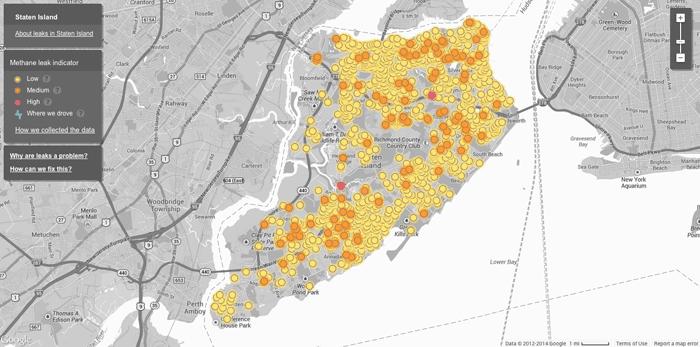
Mapping Methane Leaks with Google Street View Cars
Google partnered with the Environmental Defense Fund on a pilot project to use Google’s fleet of Street View cars to ...

No Drones Zones: Map and GIS Data
Unmanned aircraft, known more commonly as drones, have a blanket ban by the Federal Aviation Authority in the United States over military ...

Using Remote Sensing to Measure the Effect of Drought on Ground Water
This map shows a comparison of modeled relative amount of water stored in underground aquifers in the continental United States for July 7, 2014 as compared to the average for comparable weeks for the sixty year average water storage.

History of Geography as a Timeline
Listed here are significant events that happened in the field of Geography.

Maps of Israel
Printable maps of Israel. This collection of maps showing the country of Israel include a detailed map showing major cities ...

GIS Tutorial for Python Scripting
GIS Tutorial for Python Scripting is a new release from Esri Press. This workbook contains hands-on programming exercises to familiarize GIS users ...
Esri Launches GeoNet
Timing its announcement with the start of the annual Esri International User Conference, Esri has announced the launch of GeoNet, ...

Longest and Shortest Geographical Names in the World
Learn about the longest and short names for geographical locations in the world.

USGS Report on the Uses and Benefits of Landsat Imagery in Water Resources
The USGS recently published a report looking at case studies of Landsat Imagery use in water resource management within public ...

Esri Releases Explorer for ArcGIS for Mac OS
Data viewer from Esri for MacOS which offers limited functionality to "access maps, search for and visualize data."

Help Find Invasive Weeds in Hawaii
Tomnod, which previously helped with crowdsourcing the search for the missing Malaysian Airlines flight, has teamed up with the Nature Conservancy ...