
Caitlin Dempsey
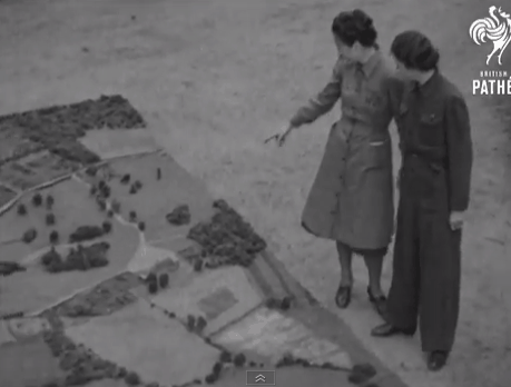
Sunday Maptinee: Map Films from British Pathé
British Pathé has released a trove of map and cartography related movies dating back to the 1930s.

How to Share ArcMap (.mxd) Files
Learn how to set up your GIS data and symbol sets so that you can share ArcMap .mxd files with others.
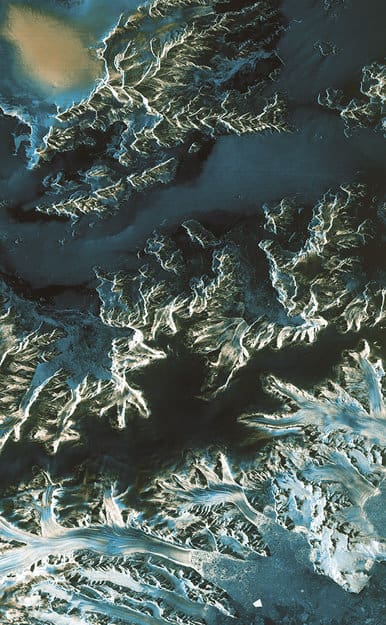
First Satellite Images from Sentinel-1A
Launched on April 3 and reaching operational altitude on April 11, the first images captured by the European Space Agency’s ...

Call for Translators: gvSIG
The developers of open source GIS software gvSIG have issued a call for translators. gvSIG is a freely downloadable GIS ...

Maps Show How Tech Bus Stops Are Affecting San Francisco Evictions
The Anti-Eviction Mapping Project has plotted out the incidences of “no-fault” evictions in San Francisco against shuttle stops for technical workers. Many ...
Join the Crowdsourced Effort to Search for the Missing Malaysian Airlines Flight
Malaysian Airlines flight 370 disappeared on Saturday, March 8, 2014. The flight left Kuala Lumpur in Malaysia on March 8 ...

Aquatic Dead Zones
Aquatic dead zones are bodies of water where the oxygen conditions are so low that marine life is unable to be supported.
Satellite Imagery Maps Out How Bad the California Drought Really is in 2014
California has been suffering from historical drought conditions. Almost all of California is experiencing drought conditions. Many parts of California ...

Sunday Maptinee: Data for Decisions
In honor of Roger Tomlinson (1933-2014), who recently died, this edition of Sunday Maptinee features Data for Decisions, a video ...

Tracking Whales with Satellite Imagery
Researchers with the British Antarctic Survey have developed a methodology to use unsupervised classification to remotely identify and count right whale populations using Very High Resolution (VHR) satellite imagery.
GIS Timeline
GIS timeline of significant milestones that have occurred since the early 1960s to advance GIS and geospatial technologies. GIS has come a long way since its beginnings.

Roger Tomlinson, Father of GIS, Has Died
Roger Tomlinson was a central figure in the development of GIS.

Submarine Cable Map
TeleGeography's 2014 Submarine Cable Map displays 285 existing or upcoming global cable systems by 2015.

Structure of the Earth
Listed here are quick facts about the earth's crust, mantle, and core.
Using Speed Data to Track the Movements of Vehicles
Researchers from Rutgers University have been testing out the theory that speed information matched against road topology provides enough information ...

How to Make Fantasy Maps
Interested in learning how to make fantasy maps? This five part tutorial from Jessica Khoury teaches users how to use Photoshop to make fantasy maps.

Mapping Ship Logs
Ben Schmidt, who is an assistant professor of history at Northeastern University, has mapped out historical shipping routes.

Magnetic North is Constantly Shifting
The magnetic poles shift each year due to changes in the Earth’s core in response to charge particles emitted by the sun hitting the earth’s magnetic field.
How to Find a Top Geography Degree Program
Learn about the different rankings for geography undergraduate and graduate degree programs and where to find resources to help you pick the best geography program.

Sunday Maptinee: The Mapmaking Process (1973)
In 1973, the United States Army produced training film TF5-4523 entitled, “The Mapmaking Process” which it described as explaining the “theory of ...

Earth Wind Map
Last year, Fernanda Viégas and Martin Wattenberg of the site Hint.FM pulled near real-time data from the National Digital Forecast Database, to ...


Tips for Using the Field Calculator in ArcGIS
The field calculator in ArcGIS is a great tool for manipulating the contents of both numerical and string fields in ArcMap. Listed here are some tips and resources for using the field calculator in ArcGIS with Python and VBScript.

Mapping 92 Years of Bigfoot Sightings
Joshua Stevens has mapped out the location of Big Foot sightings in the United States.

Mapping All the Swimming Pools in Los Angeles
Los Angeles is known for its nearly constant sunshine and warm climate so it’s no surprise that the region contains ...

Six Interesting Maps of 2013 (and One Graphic)
Everyone loves a great map. Maps engage readers and help them discover something they wouldn’t otherwise have learned about the ...